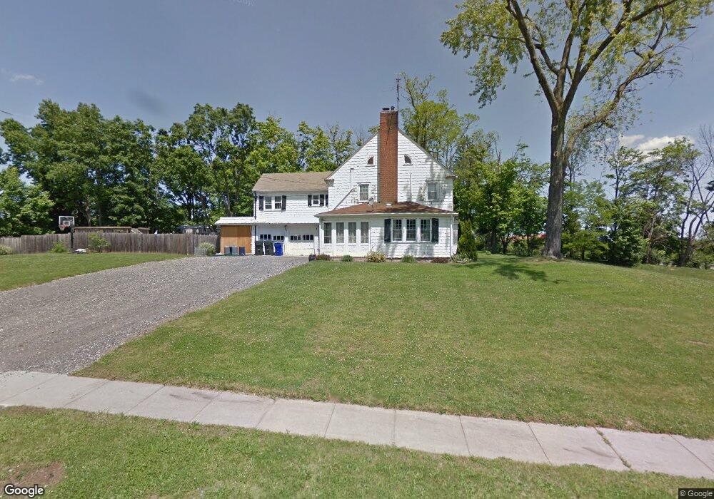
9 Dexter Rd Windsor Locks, CT 06096
Estimated Value: $339,000 - $430,000
5
Beds
4
Baths
2,757
Sq Ft
$145/Sq Ft
Est. Value
About This Home
This home is located at 9 Dexter Rd, Windsor Locks, CT 06096 and is currently estimated at $399,459, approximately $144 per square foot. 9 Dexter Rd is a home located in Hartford County with nearby schools including North Street School, South Elementary School, and Windsor Locks Middle School.
Ownership History
Date
Name
Owned For
Owner Type
Purchase Details
Closed on
Apr 12, 2019
Sold by
Smith Mary H
Bought by
Gleason Robert E and Gleason Frances M
Current Estimated Value
Home Financials for this Owner
Home Financials are based on the most recent Mortgage that was taken out on this home.
Original Mortgage
$132,000
Outstanding Balance
$115,814
Interest Rate
4.3%
Mortgage Type
Purchase Money Mortgage
Estimated Equity
$283,645
Purchase Details
Closed on
Nov 7, 2018
Sold by
Smith Steven M
Bought by
Smith Mary Helen
Purchase Details
Closed on
Dec 9, 2002
Sold by
Est Ward Anthony and Ward Anthony
Bought by
Smith Steven
Purchase Details
Closed on
Feb 28, 1991
Sold by
Est Daddabbo Pasquale
Bought by
Golas Frances W
Create a Home Valuation Report for This Property
The Home Valuation Report is an in-depth analysis detailing your home's value as well as a comparison with similar homes in the area
Home Values in the Area
Average Home Value in this Area
Purchase History
| Date | Buyer | Sale Price | Title Company |
|---|---|---|---|
| Gleason Robert E | $165,000 | -- | |
| Smith Mary Helen | -- | -- | |
| Smith Steven | $145,000 | -- | |
| Golas Frances W | $55,000 | -- |
Source: Public Records
Mortgage History
| Date | Status | Borrower | Loan Amount |
|---|---|---|---|
| Open | Gleason Robert E | $132,000 | |
| Previous Owner | Golas Frances W | $177,900 | |
| Previous Owner | Golas Frances W | $35,000 | |
| Previous Owner | Golas Frances W | $196,000 |
Source: Public Records
Tax History
| Year | Tax Paid | Tax Assessment Tax Assessment Total Assessment is a certain percentage of the fair market value that is determined by local assessors to be the total taxable value of land and additions on the property. | Land | Improvement |
|---|---|---|---|---|
| 2025 | $6,962 | $290,220 | $57,680 | $232,540 |
| 2024 | $5,185 | $184,240 | $44,870 | $139,370 |
| 2023 | $4,851 | $184,240 | $44,870 | $139,370 |
| 2022 | $4,759 | $184,240 | $44,870 | $139,370 |
| 2021 | $4,759 | $184,240 | $44,870 | $139,370 |
| 2020 | $4,759 | $184,240 | $44,870 | $139,370 |
| 2019 | $4,759 | $184,240 | $44,870 | $139,370 |
| 2017 | $4,092 | $153,500 | $47,100 | $106,400 |
| 2016 | $4,092 | $153,500 | $47,100 | $106,400 |
| 2015 | $4,112 | $153,500 | $47,100 | $106,400 |
| 2014 | $4,666 | $177,900 | $53,300 | $124,600 |
Source: Public Records
Map
Nearby Homes
- 140 S Water St
- 102 Orchard Hill Dr
- 59 Elm St
- 29 Dean Ave
- 19 Dean Ave
- 10 Dibble Hollow Ln Unit 10
- 24 Bel-Aire Cir
- 241 S Water St Unit 14
- 24 Coolidge St
- 0 N Water St Unit 24138494
- 0 N Water St Unit 24128295
- 0 N Water St Unit 24128294
- 0 N Water St Unit 24128288
- 0 N Water St
- 169 Greenwoods Ln Unit 169
- 143 Bridge St
- 217 Adams Hill Way
- 4 Pleasant St
- 248 Adams Hill Way Unit 248
- 202 Reed Ave
Your Personal Tour Guide
Ask me questions while you tour the home.