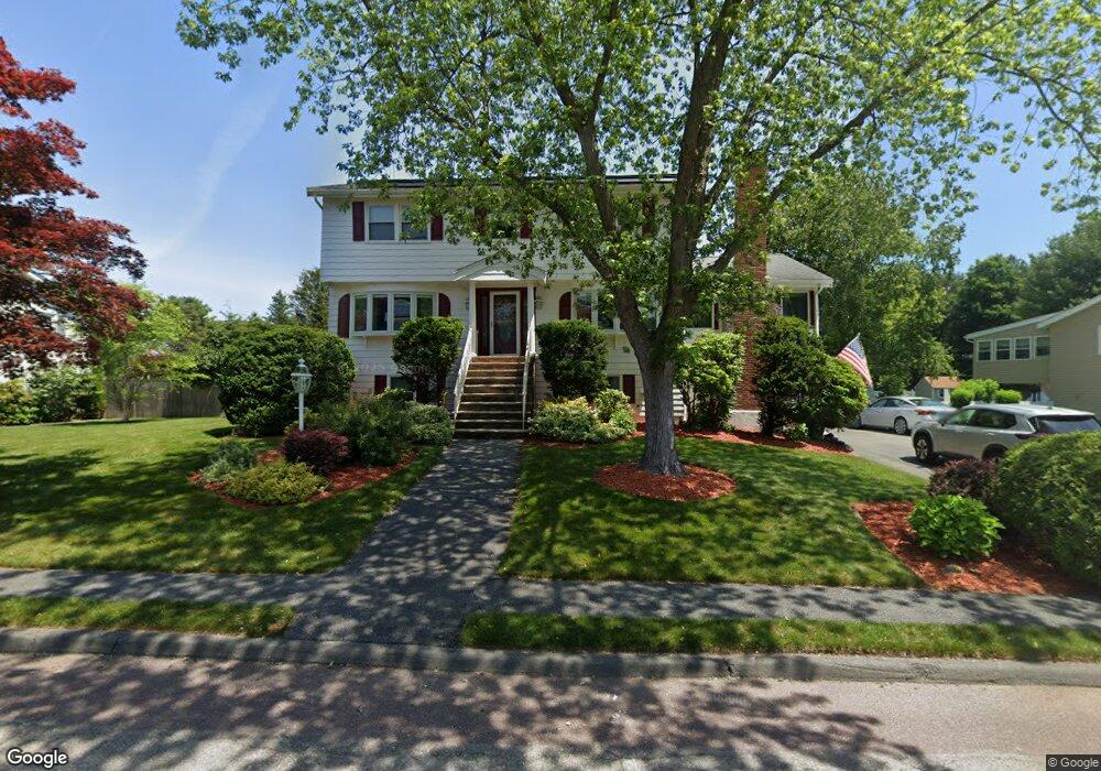
9 Fernwood Rd Saugus, MA 01906
Oakland Vale NeighborhoodEstimated Value: $1,082,284 - $1,158,000
4
Beds
5
Baths
3,575
Sq Ft
$315/Sq Ft
Est. Value
About This Home
This home is located at 9 Fernwood Rd, Saugus, MA 01906 and is currently estimated at $1,125,571, approximately $314 per square foot. 9 Fernwood Rd is a home located in Essex County with nearby schools including Saugus High School, Pioneer Charter School Of Science II, and Melrose Montessori School.
Ownership History
Date
Name
Owned For
Owner Type
Purchase Details
Closed on
May 20, 2016
Sold by
Finn Noelle and Dauenhauer Joseph F
Bought by
Finn Noelle
Current Estimated Value
Purchase Details
Closed on
Oct 2, 2012
Sold by
Dauenhauer Rt and Dauenbauer Joseph E
Bought by
Finn Noelle and Dauenhauer Dolores
Home Financials for this Owner
Home Financials are based on the most recent Mortgage that was taken out on this home.
Original Mortgage
$330,000
Interest Rate
3.62%
Mortgage Type
New Conventional
Purchase Details
Closed on
Apr 25, 2006
Sold by
Dauenhauer Rt and Dauenhauer Joseph F
Bought by
Dauenhauer Joseph F
Home Financials for this Owner
Home Financials are based on the most recent Mortgage that was taken out on this home.
Original Mortgage
$300,000
Interest Rate
6.37%
Mortgage Type
Purchase Money Mortgage
Create a Home Valuation Report for This Property
The Home Valuation Report is an in-depth analysis detailing your home's value as well as a comparison with similar homes in the area
Home Values in the Area
Average Home Value in this Area
Purchase History
| Date | Buyer | Sale Price | Title Company |
|---|---|---|---|
| Finn Noelle | -- | -- | |
| Finn Noelle | -- | -- | |
| Dauenhauer Joseph F | -- | -- |
Source: Public Records
Mortgage History
| Date | Status | Borrower | Loan Amount |
|---|---|---|---|
| Previous Owner | Finn Noelle | $330,000 | |
| Previous Owner | Dauenhauer Joseph F | $90,000 | |
| Previous Owner | Dauenhauer Joseph F | $300,000 | |
| Previous Owner | Dauenhauer Joseph F | $59,000 | |
| Previous Owner | Dauenhauer Joseph F | $80,000 |
Source: Public Records
Tax History Compared to Growth
Tax History
| Year | Tax Paid | Tax Assessment Tax Assessment Total Assessment is a certain percentage of the fair market value that is determined by local assessors to be the total taxable value of land and additions on the property. | Land | Improvement |
|---|---|---|---|---|
| 2025 | $9,405 | $880,600 | $395,000 | $485,600 |
| 2024 | $9,104 | $854,800 | $380,000 | $474,800 |
| 2023 | $8,898 | $790,200 | $345,000 | $445,200 |
| 2022 | $8,394 | $698,900 | $314,000 | $384,900 |
| 2021 | $8,118 | $657,900 | $273,000 | $384,900 |
| 2020 | $7,721 | $647,700 | $273,000 | $374,700 |
| 2019 | $7,505 | $616,200 | $260,000 | $356,200 |
| 2018 | $6,924 | $597,900 | $247,000 | $350,900 |
| 2017 | $6,802 | $564,500 | $235,000 | $329,500 |
| 2016 | $6,895 | $565,200 | $224,800 | $340,400 |
| 2015 | $6,517 | $542,200 | $214,000 | $328,200 |
| 2014 | $5,709 | $491,700 | $214,000 | $277,700 |
Source: Public Records
Map
Nearby Homes
- 86 Lynn Fells Pkwy
- 1104 Lewis o Gray Dr
- 2 Oaklandvale Ave
- 1203 Sheffield Way
- 1607 Lewis o Gray Dr
- 16 Breakheart Rd
- 15 Shore Rd
- 110 Ellis Farm Ln
- 760 Lynn Fells Pkwy
- 148 Forest St
- 80 Forest St
- 118 N Woodcrest Dr
- 409 Lynn Fells Pkwy
- 9 Thomas St Unit 5
- 26 Magnolia Rd
- 5 Hammersmith Dr
- 46 Country Club Rd
- 515 Upham St
- 14 Kayla Dr
- 76 Lovell Rd