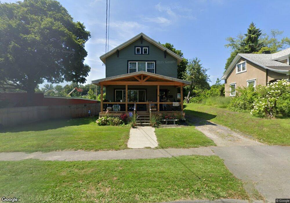
9 Hawthorne Ave Pittsfield, MA 01201
Estimated Value: $229,000 - $479,000
3
Beds
1
Bath
1,482
Sq Ft
$199/Sq Ft
Est. Value
About This Home
This home is located at 9 Hawthorne Ave, Pittsfield, MA 01201 and is currently estimated at $295,339, approximately $199 per square foot. 9 Hawthorne Ave is a home located in Berkshire County with nearby schools including Silvio O. Conte Community School, John T. Reid Middle School, and Taconic High School.
Ownership History
Date
Name
Owned For
Owner Type
Purchase Details
Closed on
May 17, 2019
Sold by
Casella Robert J
Bought by
Casella Robert J and Coty Sharry L
Current Estimated Value
Purchase Details
Closed on
Apr 6, 1989
Sold by
Casella Robert J
Bought by
Casella Robert J
Create a Home Valuation Report for This Property
The Home Valuation Report is an in-depth analysis detailing your home's value as well as a comparison with similar homes in the area
Home Values in the Area
Average Home Value in this Area
Purchase History
| Date | Buyer | Sale Price | Title Company |
|---|---|---|---|
| Casella Robert J | -- | -- | |
| Casella Robert J | $65,000 | -- |
Source: Public Records
Mortgage History
| Date | Status | Borrower | Loan Amount |
|---|---|---|---|
| Previous Owner | Casella Robert J | $138,500 | |
| Previous Owner | Casella Robert J | $9,250 | |
| Previous Owner | Casella Robert J | $18,300 | |
| Previous Owner | Casella Robert J | $52,500 |
Source: Public Records
Tax History Compared to Growth
Tax History
| Year | Tax Paid | Tax Assessment Tax Assessment Total Assessment is a certain percentage of the fair market value that is determined by local assessors to be the total taxable value of land and additions on the property. | Land | Improvement |
|---|---|---|---|---|
| 2025 | $2,958 | $164,900 | $50,400 | $114,500 |
| 2024 | $2,740 | $148,500 | $50,400 | $98,100 |
| 2023 | $2,477 | $135,200 | $45,600 | $89,600 |
| 2022 | $2,288 | $123,300 | $45,600 | $77,700 |
| 2021 | $2,114 | $109,800 | $45,600 | $64,200 |
| 2020 | $2,123 | $107,700 | $45,600 | $62,100 |
| 2019 | $2,156 | $111,000 | $45,600 | $65,400 |
| 2018 | $2,175 | $108,700 | $45,600 | $63,100 |
| 2017 | $1,998 | $101,800 | $48,700 | $53,100 |
| 2016 | $1,876 | $100,000 | $48,700 | $51,300 |
| 2015 | $1,806 | $100,000 | $48,700 | $51,300 |
Source: Public Records
Map
Nearby Homes
- 28 Mckinley Terrace
- 20 Greenway St
- 96 Boylston St
- 92 W Housatonic St
- 71 S Church St Unit S102
- 36 George St
- 156 Elizabeth St
- 31 Henry Ave
- 50 W Housatonic St
- 79 Center St
- 247 South St
- 32 Velma Ave
- 13 Goodrich St
- 1 Colt Rd Unit 2
- 18 Velma Ave
- 33 Circular Ave
- 5 Crofut St
- 209 Velma Ave
- 127 Gamwell Ave
- 174 Cole Ave
- 15 Hawthorne Ave
- 220 W Housatonic St
- 21 Hawthorne Ave
- 29 Hawthorne Ave
- 37 Hawthorne Ave
- 200 W Housatonic St Unit 13
- 200 W Housatonic St Unit 25
- 200 W Housatonic St Unit 17
- 200 W Housatonic St Unit 3
- 200 W Housatonic St Unit 8
- 200 W Housatonic St Unit 21
- 200 W Housatonic St Unit 1
- 200 W Housatonic St Unit 15
- 200 W Housatonic St Unit 19
- 200 W Housatonic St Unit 10
- 200 W Housatonic St Unit 14
- 200 W Housatonic St Unit 20
- 200 W Housatonic St Unit 22
- 200 W Housatonic St
- 200 W Housatonic St Unit 27