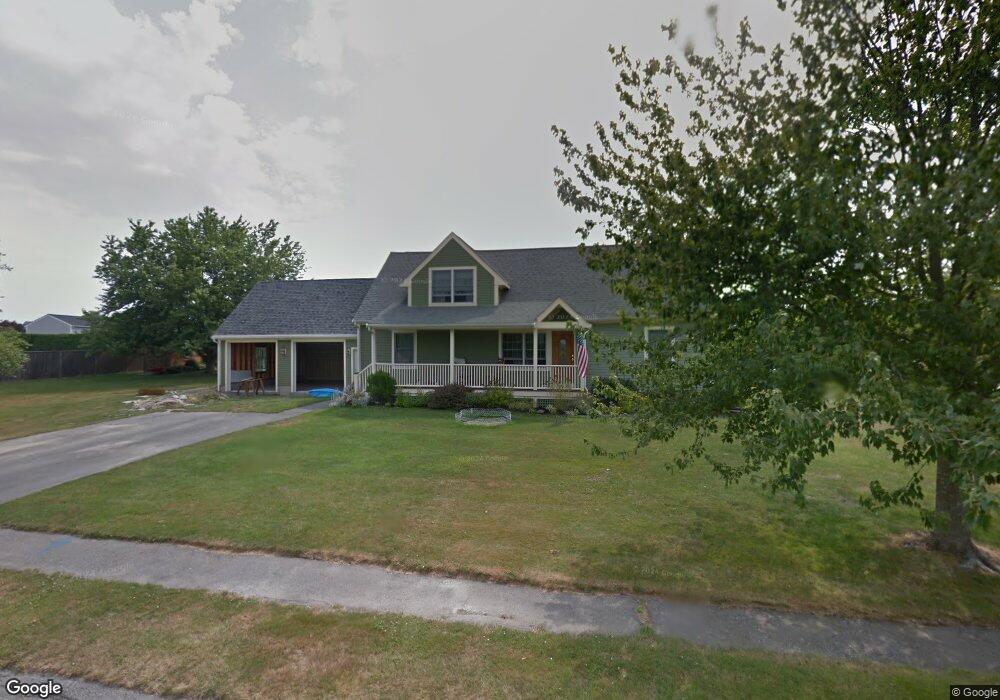
9 Hunt Ln Middletown, RI 02842
Estimated Value: $867,000 - $1,013,000
3
Beds
2
Baths
2,131
Sq Ft
$443/Sq Ft
Est. Value
About This Home
This home is located at 9 Hunt Ln, Middletown, RI 02842 and is currently estimated at $943,863, approximately $442 per square foot. 9 Hunt Ln is a home located in Newport County with nearby schools including Middletown High School, St Michael's Country Day School, and All Saints STEAM Academy.
Ownership History
Date
Name
Owned For
Owner Type
Purchase Details
Closed on
May 17, 2024
Sold by
Levada Alan G and Levada Marie V
Bought by
Alan G Levada Ret and Levada
Current Estimated Value
Purchase Details
Closed on
Jun 28, 1991
Sold by
Freitas Frank
Bought by
Levada Allan G
Home Financials for this Owner
Home Financials are based on the most recent Mortgage that was taken out on this home.
Original Mortgage
$27,206
Interest Rate
9.44%
Mortgage Type
Purchase Money Mortgage
Create a Home Valuation Report for This Property
The Home Valuation Report is an in-depth analysis detailing your home's value as well as a comparison with similar homes in the area
Home Values in the Area
Average Home Value in this Area
Purchase History
| Date | Buyer | Sale Price | Title Company |
|---|---|---|---|
| Alan G Levada Ret | -- | None Available | |
| Alan G Levada Ret | -- | None Available | |
| Levada Allan G | $129,000 | -- |
Source: Public Records
Mortgage History
| Date | Status | Borrower | Loan Amount |
|---|---|---|---|
| Previous Owner | Levada Allan G | $210,000 | |
| Previous Owner | Levada Allan G | $190,000 | |
| Previous Owner | Levada Allan G | $27,206 |
Source: Public Records
Tax History Compared to Growth
Tax History
| Year | Tax Paid | Tax Assessment Tax Assessment Total Assessment is a certain percentage of the fair market value that is determined by local assessors to be the total taxable value of land and additions on the property. | Land | Improvement |
|---|---|---|---|---|
| 2025 | $10,370 | $879,600 | $519,500 | $360,100 |
| 2024 | $9,904 | $879,600 | $519,500 | $360,100 |
| 2023 | $7,640 | $606,800 | $279,400 | $327,400 |
| 2022 | $6,627 | $551,300 | $279,400 | $271,900 |
| 2021 | $6,616 | $550,400 | $279,400 | $271,000 |
| 2020 | $6,277 | $456,200 | $213,700 | $242,500 |
| 2018 | $6,273 | $456,200 | $213,700 | $242,500 |
| 2016 | $6,282 | $407,400 | $184,700 | $222,700 |
| 2015 | $6,127 | $407,400 | $184,700 | $222,700 |
| 2014 | $5,988 | $372,600 | $167,900 | $204,700 |
| 2013 | $5,854 | $372,600 | $167,900 | $204,700 |
Source: Public Records
Map
Nearby Homes
- 980 Green End Ave
- 119 Corey Ln
- 310 Corey Ln
- 223 Corey Ln
- 318 Corey Ln
- 0 Saltwood Dr
- 16 Sachuest Dr
- 0 Honeyman Ave
- 476 Green End Ave
- 141 Gray Craig Rd
- 62 Howland Ave
- 10 Bartlett Rd
- 0 Wolcott Ave
- 118 Wolcott Ave
- 6 Wabasso Terrace
- 55 John Clarke Rd Unit 8
- 55 John Clarke Rd Unit 3
- 74 Valley Rd
- 515 Indian Ave
- 162 Center Ave