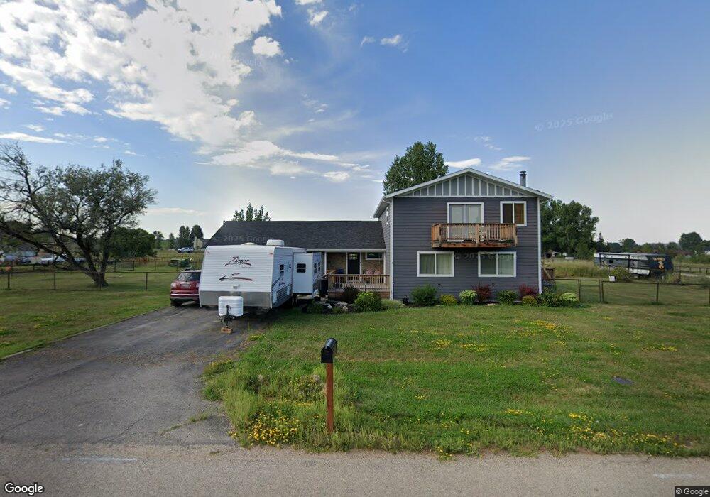
9 Knode Rd Sheridan, WY 82801
Estimated Value: $656,241 - $940,000
3
Beds
2
Baths
2,158
Sq Ft
$367/Sq Ft
Est. Value
About This Home
This home is located at 9 Knode Rd, Sheridan, WY 82801 and is currently estimated at $791,080, approximately $366 per square foot. 9 Knode Rd is a home.
Ownership History
Date
Name
Owned For
Owner Type
Purchase Details
Closed on
May 5, 2017
Sold by
Redenbaugh Thomas
Bought by
Harnish Tyler and Harnish Danielle
Current Estimated Value
Home Financials for this Owner
Home Financials are based on the most recent Mortgage that was taken out on this home.
Original Mortgage
$288,000
Outstanding Balance
$239,508
Interest Rate
4.1%
Mortgage Type
New Conventional
Estimated Equity
$551,572
Purchase Details
Closed on
Nov 14, 2016
Sold by
U S Bank Na
Bought by
Redenbaugh Thomas
Create a Home Valuation Report for This Property
The Home Valuation Report is an in-depth analysis detailing your home's value as well as a comparison with similar homes in the area
Home Values in the Area
Average Home Value in this Area
Purchase History
| Date | Buyer | Sale Price | Title Company |
|---|---|---|---|
| Harnish Tyler | -- | None Available | |
| Redenbaugh Thomas | $197,000 | None Available |
Source: Public Records
Mortgage History
| Date | Status | Borrower | Loan Amount |
|---|---|---|---|
| Open | Harnish Tyler | $288,000 |
Source: Public Records
Tax History Compared to Growth
Tax History
| Year | Tax Paid | Tax Assessment Tax Assessment Total Assessment is a certain percentage of the fair market value that is determined by local assessors to be the total taxable value of land and additions on the property. | Land | Improvement |
|---|---|---|---|---|
| 2025 | $3,723 | $42,496 | $19,055 | $23,441 |
| 2024 | $3,723 | $55,152 | $25,407 | $29,745 |
| 2023 | $3,674 | $54,435 | $23,642 | $30,793 |
| 2022 | $3,221 | $47,722 | $19,408 | $28,314 |
| 2021 | $2,720 | $40,298 | $16,408 | $23,890 |
| 2020 | $2,429 | $35,978 | $13,233 | $22,745 |
| 2019 | $2,317 | $34,319 | $13,233 | $21,086 |
| 2018 | $2,057 | $30,480 | $12,350 | $18,130 |
| 2017 | $1,437 | $20,829 | $11,998 | $8,831 |
| 2015 | $1,857 | $26,685 | $9,605 | $17,080 |
| 2014 | $1,881 | $27,022 | $9,605 | $17,417 |
| 2013 | -- | $26,182 | $9,605 | $16,577 |
Source: Public Records
Map
Nearby Homes
- 91 Wyoming 335
- 8 Buckskin Dr
- 96 Canvasback Rd
- 21 Wishbone Way
- 4 Mallard Rd
- 3 Mallard Rd
- Tbd Wagon Wheel Court Lot F11
- Tbd Wagon Wheel Ct Lot F10 & F11
- TBD Wagon Wheel Ct Unit F10
- TBD Wagon Wheel Ct Unit F11
- TBD Wagon Wheel Ct Unit Lot 1
- TBD Wagon Wheel Ct Unit Lot 2
- 40 Mallard Rd
- 1 Deer Haven Dr
- 7 Mallard Rd
- 19 Spring Creek Ln
- 21 Eagle Ridge Dr
- 3 Thunderbird Dr
- 5 Oakmont Ct
- TBD Powder Horn Rd
- 12 Knode Rd
- 3 Knode Rd
- 11 Knode Rd
- 1134 Cross Creek Ct
- 0 Wildflower Cir
- 1 Goose Meadows Rd
- 1132 Cross Creek Ct
- 3 Goose Meadows Rd
- 51 Green Meadows Dr
- 135 Wildflower Cir
- 101 Wildflower Cir
- 131 Wildflower Cir
- 105 Wildflower Cir
- 181 Wildflower Cir
- 185 Wildflower Cir
- 47 Green Meadows Dr
- 1136 Cross Creek Ct
- 48 Green Meadows Dr
- 45 Green Meadows Dr
- 44 Green Meadows Dr