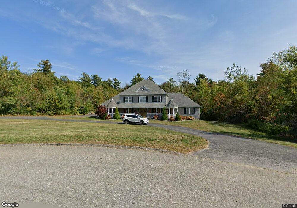
9 Lowry Ln Rutland, MA 01543
Estimated Value: $866,938 - $1,077,000
4
Beds
4
Baths
2,500
Sq Ft
$380/Sq Ft
Est. Value
About This Home
This home is located at 9 Lowry Ln, Rutland, MA 01543 and is currently estimated at $950,985, approximately $380 per square foot. 9 Lowry Ln is a home located in Worcester County with nearby schools including Wachusett Regional High School.
Ownership History
Date
Name
Owned For
Owner Type
Purchase Details
Closed on
Jun 15, 2016
Sold by
Dillon Joanne L
Bought by
Collette Tyler H and Collette Christina A
Current Estimated Value
Home Financials for this Owner
Home Financials are based on the most recent Mortgage that was taken out on this home.
Original Mortgage
$470,400
Outstanding Balance
$374,873
Interest Rate
3.61%
Mortgage Type
VA
Estimated Equity
$576,112
Create a Home Valuation Report for This Property
The Home Valuation Report is an in-depth analysis detailing your home's value as well as a comparison with similar homes in the area
Home Values in the Area
Average Home Value in this Area
Purchase History
| Date | Buyer | Sale Price | Title Company |
|---|---|---|---|
| Collette Tyler H | $475,000 | -- |
Source: Public Records
Mortgage History
| Date | Status | Borrower | Loan Amount |
|---|---|---|---|
| Open | Collette Tyler H | $470,400 |
Source: Public Records
Tax History Compared to Growth
Tax History
| Year | Tax Paid | Tax Assessment Tax Assessment Total Assessment is a certain percentage of the fair market value that is determined by local assessors to be the total taxable value of land and additions on the property. | Land | Improvement |
|---|---|---|---|---|
| 2025 | $11,905 | $836,000 | $159,900 | $676,100 |
| 2024 | $13,168 | $887,900 | $150,200 | $737,700 |
| 2023 | $12,155 | $885,900 | $143,100 | $742,800 |
| 2022 | $11,224 | $710,800 | $123,500 | $587,300 |
| 2021 | $11,107 | $665,100 | $131,700 | $533,400 |
| 2020 | $9,182 | $521,400 | $120,900 | $400,500 |
| 2019 | $9,022 | $504,300 | $108,100 | $396,200 |
| 2018 | $8,670 | $478,200 | $108,100 | $370,100 |
| 2017 | $10,952 | $597,800 | $108,100 | $489,700 |
| 2016 | $10,295 | $592,700 | $106,700 | $486,000 |
| 2015 | $10,136 | $574,300 | $106,700 | $467,600 |
| 2014 | $9,826 | $574,300 | $106,700 | $467,600 |
Source: Public Records
Map
Nearby Homes
- 271 Glenwood Rd
- 81 Glenwood Place
- 147 E County Rd Unit 149
- 139 E County Rd Unit 139
- 175 Glenwood Rd
- 101 Brintnal Dr
- 73 Brintnal Dr
- 166 Ball Hill Rd
- 35 Brintnal Dr
- 2 Simon Davis Dr
- 25 Watson Ln
- 16 Richards Ave
- 15 Stagecoach Rd
- 40 Brunelle Dr
- 55 Pommogussett Rd
- 56 Hubbardston Rd
- 9 Stagecoach Rd
- 81 Central Tree Rd
- 32 Pommogussett Rd Unit 1
- 10 Beechwood Dr