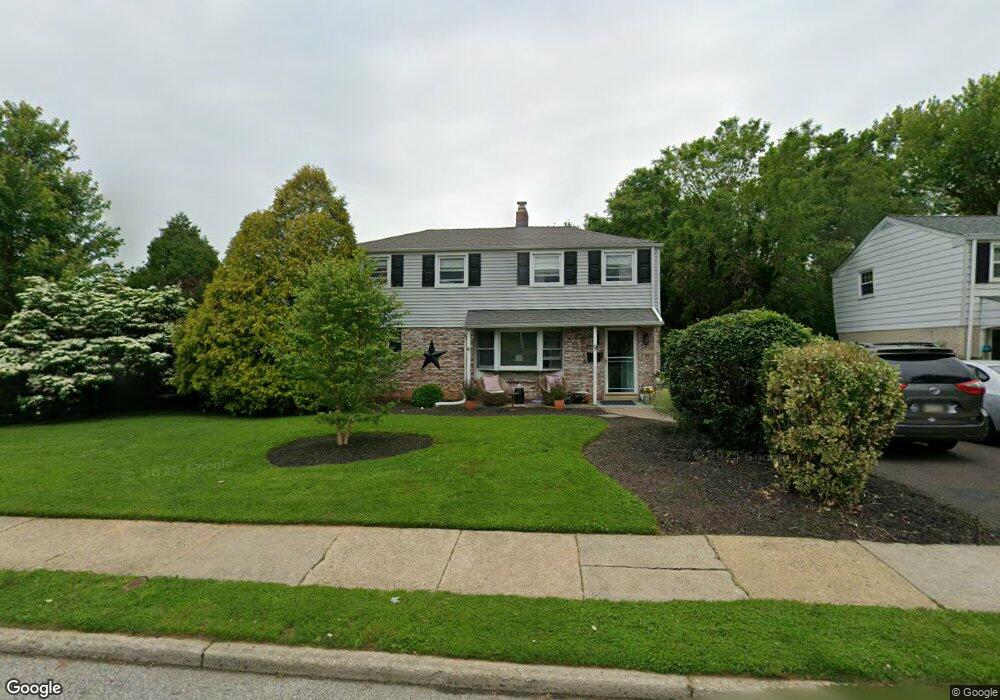
9 Mccloskey Rd Flourtown, PA 19031
Estimated Value: $483,000 - $524,000
3
Beds
2
Baths
1,691
Sq Ft
$300/Sq Ft
Est. Value
About This Home
This home is located at 9 Mccloskey Rd, Flourtown, PA 19031 and is currently estimated at $506,823, approximately $299 per square foot. 9 Mccloskey Rd is a home located in Montgomery County with nearby schools including Erdenheim Elementary School, Enfield Elementary School, and Springfield Township Middle School.
Ownership History
Date
Name
Owned For
Owner Type
Purchase Details
Closed on
Oct 8, 2010
Sold by
Welsh Amy and Welsh Curtis
Bought by
Ferguson Kenneth and Ferguson Shannon
Current Estimated Value
Home Financials for this Owner
Home Financials are based on the most recent Mortgage that was taken out on this home.
Original Mortgage
$285,000
Outstanding Balance
$188,452
Interest Rate
4.39%
Estimated Equity
$318,371
Purchase Details
Closed on
Nov 4, 2005
Sold by
Walsh Stephen and Walsh Resa
Bought by
Welsh Curtis and Welsh Amy
Home Financials for this Owner
Home Financials are based on the most recent Mortgage that was taken out on this home.
Original Mortgage
$257,600
Interest Rate
6.07%
Purchase Details
Closed on
Apr 15, 1999
Sold by
Dwyer Patricia M
Bought by
Walsh Stephen and Walsh Reesa
Create a Home Valuation Report for This Property
The Home Valuation Report is an in-depth analysis detailing your home's value as well as a comparison with similar homes in the area
Home Values in the Area
Average Home Value in this Area
Purchase History
| Date | Buyer | Sale Price | Title Company |
|---|---|---|---|
| Ferguson Kenneth | $300,000 | None Available | |
| Welsh Curtis | $322,000 | -- | |
| Walsh Stephen | $170,000 | -- |
Source: Public Records
Mortgage History
| Date | Status | Borrower | Loan Amount |
|---|---|---|---|
| Open | Ferguson Kenneth | $285,000 | |
| Previous Owner | Welsh Curtis | $257,600 |
Source: Public Records
Tax History
| Year | Tax Paid | Tax Assessment Tax Assessment Total Assessment is a certain percentage of the fair market value that is determined by local assessors to be the total taxable value of land and additions on the property. | Land | Improvement |
|---|---|---|---|---|
| 2025 | $6,760 | $143,530 | $43,610 | $99,920 |
| 2024 | $6,760 | $143,530 | $43,610 | $99,920 |
| 2023 | $6,525 | $143,530 | $43,610 | $99,920 |
| 2022 | $6,338 | $143,530 | $43,610 | $99,920 |
| 2021 | $6,173 | $143,530 | $43,610 | $99,920 |
| 2020 | $6,028 | $143,530 | $43,610 | $99,920 |
| 2019 | $5,936 | $143,530 | $43,610 | $99,920 |
Source: Public Records
Map
Nearby Homes
- 28 Grove Ave
- 111 Chesney Ln
- 300 Preston Rd
- 216 Heatherwood Rd
- 5 Highland Ave Unit 30
- 107 E Mill Rd
- 402 Pennybrook Ct
- 401 Pennybrook Ct Unit 1 REDFORD END
- 001 Pennybrook Ct Unit REDFORD INTERIOR
- 403 Pennybrook Ct Unit 2 REDFORD INTERIOR
- 405 Pennybrook Ct Unit 3 REDFORD INTERIOR
- 404 Pennybrook Ct Unit 15 REDFORD INTERIOR
- 407 Pennybrook Ct Unit 4 REDFORD END
- 305 Glenway Rd
- 502 E Mill Rd
- 423 Pennybrook Ct Unit 6 REDFORD INTERIOR
- 421 Pennybrook Ct Unit 5 REDFORD END
- 32 Windsor Rd
- 99 Rorer St
- 418 Glenway Rd
- 11 Mccloskey Rd
- 13 Mccloskey Rd
- 10 E Wissahickon Ave
- 1300 Bethlehem Pike Unit 32
- 1300 Bethlehem Pike Unit 110
- 1300 Bethlehem Pike Unit 310
- 1300 Bethlehem Pike
- 1300 Bethlehem Pike Unit 12
- 1300 Bethlehem Pike Unit 11
- 1300 Bethlehem Pike Unit 23
- 1300 Bethlehem Pike Unit 31
- 1300 Bethlehem Pike Unit 33
- 12 E Wissahickon Ave
- 10 Mccloskey Rd
- 12 Mccloskey Rd
- 14 E Wissahickon Ave
- 14 Mccloskey Rd
- 16 E Wissahickon Ave
- 17 Mccloskey Rd
- 9 E Wissahickon Ave
Your Personal Tour Guide
Ask me questions while you tour the home.