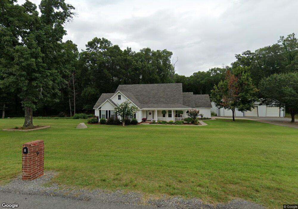
9 Mckenzie Trail Conway, AR 72032
Estimated Value: $432,847 - $469,000
4
Beds
3
Baths
2,417
Sq Ft
$187/Sq Ft
Est. Value
About This Home
This home is located at 9 Mckenzie Trail, Conway, AR 72032 and is currently estimated at $450,924, approximately $186 per square foot. 9 Mckenzie Trail is a home located in Faulkner County with nearby schools including Vilonia Junior High School and Vilonia High School.
Ownership History
Date
Name
Owned For
Owner Type
Purchase Details
Closed on
Feb 22, 2012
Sold by
Richardson Tim and Richardson Jennifer
Bought by
Stnnett Eklizabeth S and Stnnett Michael E
Current Estimated Value
Home Financials for this Owner
Home Financials are based on the most recent Mortgage that was taken out on this home.
Original Mortgage
$170,000
Outstanding Balance
$20,812
Interest Rate
4.05%
Mortgage Type
New Conventional
Estimated Equity
$430,112
Create a Home Valuation Report for This Property
The Home Valuation Report is an in-depth analysis detailing your home's value as well as a comparison with similar homes in the area
Home Values in the Area
Average Home Value in this Area
Purchase History
| Date | Buyer | Sale Price | Title Company |
|---|---|---|---|
| Stnnett Eklizabeth S | $217,000 | None Available |
Source: Public Records
Mortgage History
| Date | Status | Borrower | Loan Amount |
|---|---|---|---|
| Open | Stnnett Eklizabeth S | $170,000 |
Source: Public Records
Tax History
| Year | Tax Paid | Tax Assessment Tax Assessment Total Assessment is a certain percentage of the fair market value that is determined by local assessors to be the total taxable value of land and additions on the property. | Land | Improvement |
|---|---|---|---|---|
| 2025 | $2,864 | $84,100 | $9,030 | $75,070 |
| 2024 | $2,745 | $84,100 | $9,030 | $75,070 |
| 2023 | $2,615 | $57,880 | $6,010 | $51,870 |
| 2022 | $2,176 | $57,880 | $6,010 | $51,870 |
| 2021 | $2,062 | $57,880 | $6,010 | $51,870 |
| 2020 | $1,949 | $47,170 | $6,010 | $41,160 |
| 2019 | $1,939 | $47,170 | $6,010 | $41,160 |
| 2018 | $1,964 | $47,170 | $6,010 | $41,160 |
| 2017 | $1,964 | $47,170 | $6,010 | $41,160 |
| 2016 | $1,964 | $47,170 | $6,010 | $41,160 |
| 2015 | $2,256 | $46,810 | $6,010 | $40,800 |
| 2014 | $1,712 | $41,950 | $6,010 | $35,940 |
Source: Public Records
Map
Nearby Homes
- 738 Highway 64 B
- 66 Eaglebrook Dr
- 25 S Simon Ln
- 000 Hwy 64 E
- 678 Main St
- Lot 19 Liberty Creek Rd
- 15 Appaloosa Trail
- 92 Hickory Ridge Rd
- 599 Beryl Rd S
- 25 Sun Drenched Trail
- 6 Brentwood Dr
- 0 Hwy 64 E Unit 25050006
- 1 Justice Farm Rd
- 111 Justice Farm Rd
- 25 Brentwood Dr
- 9 Hickory Ridge Rd
- 24 Darrell St
- 16 Eagle Valley Rd
- TBD Eagle Valley Rd
- 31 Waterloo Loop
- Lot 1 & 2 E Mckenzie Trail
- Lot 2 E Mckenzie Trail
- 13 Mckenzie Trail
- 5 Mckenzie Trail
- Lot 3 Mckenzie Meadow
- 14 Cook Ln
- 6 Cook Ln
- 17 Mckenzie Trail
- 741 Main St
- 741 Main St
- 8 Cook Ln
- 0 Mckenzie Trail Unit 16023422
- 16 Cook Ln
- 2 Kali Ct
- 21 Mckenzie Trail
- 9 Cook Ln
- 753 Main St Unit A
- 737 Main St
- 737 Main St
- 733 Cook Ln