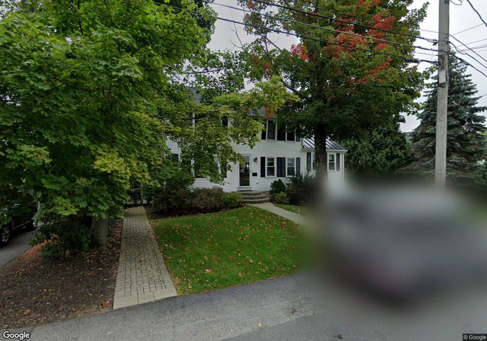
9 Porter Rd Waltham, MA 02452
North Waltham NeighborhoodEstimated Value: $1,031,297 - $1,229,000
3
Beds
4
Baths
2,598
Sq Ft
$438/Sq Ft
Est. Value
About This Home
This home is located at 9 Porter Rd, Waltham, MA 02452 and is currently estimated at $1,137,324, approximately $437 per square foot. 9 Porter Rd is a home located in Middlesex County with nearby schools including Northeast Elementary School, John F Kennedy Middle School, and Waltham Sr High School.
Ownership History
Date
Name
Owned For
Owner Type
Purchase Details
Closed on
May 1, 2023
Sold by
Sulahian Dikran Z and Sulahian Maral M
Bought by
Dikran Z Sulahian Ret and Sulahian
Current Estimated Value
Purchase Details
Closed on
Nov 19, 2008
Sold by
Stanton Carol Ann and Stanton William M
Bought by
Sulahian Dikran and Sulahian Maral
Home Financials for this Owner
Home Financials are based on the most recent Mortgage that was taken out on this home.
Original Mortgage
$412,000
Interest Rate
6.03%
Mortgage Type
Purchase Money Mortgage
Purchase Details
Closed on
Jun 26, 1992
Sold by
Snow Development Corp
Bought by
Stanton William M and Stanton Carol A
Create a Home Valuation Report for This Property
The Home Valuation Report is an in-depth analysis detailing your home's value as well as a comparison with similar homes in the area
Home Values in the Area
Average Home Value in this Area
Purchase History
| Date | Buyer | Sale Price | Title Company |
|---|---|---|---|
| Dikran Z Sulahian Ret | -- | None Available | |
| Sulahian Dikran | $515,000 | -- | |
| Stanton William M | $231,500 | -- |
Source: Public Records
Mortgage History
| Date | Status | Borrower | Loan Amount |
|---|---|---|---|
| Previous Owner | Sulahian Dikran | $412,000 |
Source: Public Records
Tax History
| Year | Tax Paid | Tax Assessment Tax Assessment Total Assessment is a certain percentage of the fair market value that is determined by local assessors to be the total taxable value of land and additions on the property. | Land | Improvement |
|---|---|---|---|---|
| 2025 | $8,518 | $867,400 | $427,100 | $440,300 |
| 2024 | $8,093 | $839,500 | $407,100 | $432,400 |
| 2023 | $7,976 | $772,900 | $370,100 | $402,800 |
| 2022 | $8,330 | $747,800 | $362,700 | $385,100 |
| 2021 | $21,073 | $707,400 | $347,900 | $359,500 |
| 2020 | $8,029 | $671,900 | $325,700 | $346,200 |
| 2019 | $7,631 | $602,800 | $311,800 | $291,000 |
| 2018 | $6,962 | $552,100 | $288,700 | $263,400 |
| 2017 | $6,609 | $526,200 | $262,800 | $263,400 |
| 2016 | $6,305 | $515,100 | $251,700 | $263,400 |
| 2015 | $6,214 | $473,300 | $225,700 | $247,600 |
Source: Public Records
Map
Nearby Homes
- 100 Shirley Rd
- 43 Agassiz Ave
- 50 Moraine St
- 51 Harrington St Unit 51
- 345 Bishops Forest Dr
- 43-43A Chandler St
- 31 Greensbrook Way
- 289 Bishops Forest Dr
- 135 Marsh St
- 40 Knowles Rd
- 144-146 White St
- 52 Hawthorne St Unit 1
- 78 Barbara Rd Unit 1
- 107 Clocktower Dr Unit 3302
- 918 Belmont St
- 49 Pierce Rd Unit 49
- 53 Crestview Rd
- 9 Henry St Unit 9
- 3 Henry St
- 314 Lexington St
Your Personal Tour Guide
Ask me questions while you tour the home.