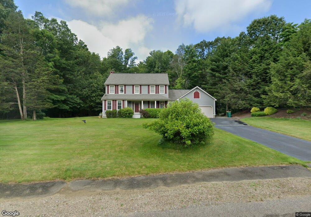
9 Shannon Marie Way North Easton, MA 02356
Estimated Value: $761,000 - $851,000
3
Beds
3
Baths
2,118
Sq Ft
$385/Sq Ft
Est. Value
About This Home
This home is located at 9 Shannon Marie Way, North Easton, MA 02356 and is currently estimated at $815,490, approximately $385 per square foot. 9 Shannon Marie Way is a home located in Bristol County with nearby schools including Easton Middle School and St Mary's Catholic School.
Ownership History
Date
Name
Owned For
Owner Type
Purchase Details
Closed on
Aug 31, 2000
Sold by
Pino Paul G and Pino Coleen
Bought by
West Karen and West Richard
Current Estimated Value
Home Financials for this Owner
Home Financials are based on the most recent Mortgage that was taken out on this home.
Original Mortgage
$252,000
Interest Rate
8.16%
Mortgage Type
Purchase Money Mortgage
Create a Home Valuation Report for This Property
The Home Valuation Report is an in-depth analysis detailing your home's value as well as a comparison with similar homes in the area
Home Values in the Area
Average Home Value in this Area
Purchase History
| Date | Buyer | Sale Price | Title Company |
|---|---|---|---|
| West Karen | $315,000 | -- | |
| West Karen | $315,000 | -- |
Source: Public Records
Mortgage History
| Date | Status | Borrower | Loan Amount |
|---|---|---|---|
| Open | West Karen | $287,000 | |
| Closed | West Karen | $250,900 | |
| Closed | West Karen | $252,000 | |
| Closed | West Karen | $47,250 |
Source: Public Records
Tax History Compared to Growth
Tax History
| Year | Tax Paid | Tax Assessment Tax Assessment Total Assessment is a certain percentage of the fair market value that is determined by local assessors to be the total taxable value of land and additions on the property. | Land | Improvement |
|---|---|---|---|---|
| 2025 | $8,778 | $703,400 | $381,000 | $322,400 |
| 2024 | $8,778 | $657,500 | $336,200 | $321,300 |
| 2023 | $8,869 | $607,900 | $336,200 | $271,700 |
| 2022 | $8,255 | $536,400 | $274,700 | $261,700 |
| 2021 | $7,886 | $509,400 | $247,700 | $261,700 |
| 2020 | $7,565 | $491,900 | $237,800 | $254,100 |
| 2019 | $7,651 | $479,400 | $231,900 | $247,500 |
| 2018 | $7,068 | $451,300 | $219,500 | $231,800 |
| 2017 | $7,067 | $435,700 | $219,500 | $216,200 |
| 2016 | $7,383 | $456,000 | $250,200 | $205,800 |
| 2015 | $6,873 | $409,600 | $203,800 | $205,800 |
| 2014 | $6,823 | $409,800 | $206,600 | $203,200 |
Source: Public Records
Map
Nearby Homes
- 34 Kevins Way
- 23 Estelle Marsan Dr
- 29 Owl Ridge Rd
- 55 Eastman St
- 98 Massapoag Ave
- 16 Erick Rd Unit 34
- 157 Highland St
- 151 Stearns Ave
- 28 Heidi Rd
- 6 Erick Rd Unit 73
- 36 Sierra Dr
- 11 Hilltop Ln
- 6 Pinebrook Ln Unit 6
- 3 Cushing Ln
- 555 Foundry St Unit B
- Starling Plan at Sawmill Village
- Mallard Plan at Sawmill Village
- Goldfinch Plan at Sawmill Village
- Falcon Plan at Sawmill Village
- Cardinal Plan at Sawmill Village
- 142 Chestnut St
- 146 Chestnut St
- 138 Chestnut St
- 29 Hancock St
- 134 Chestnut St
- 8 Shannon Marie Way
- 27 Hancock St Lot 27
- 27 Hancock St
- 27 Hancock St Unit 27
- 139 Chestnut St
- 162 Chestnut St
- 23 Hancock St
- 23 Hancock St Unit 23
- 137 Chestnut St
- 130 Chestnut St
- 25 Hancock St
- 158 Chestnut St
- Lot 25 Hancock St
- 133 Chestnut St
- 154 Chestnut St