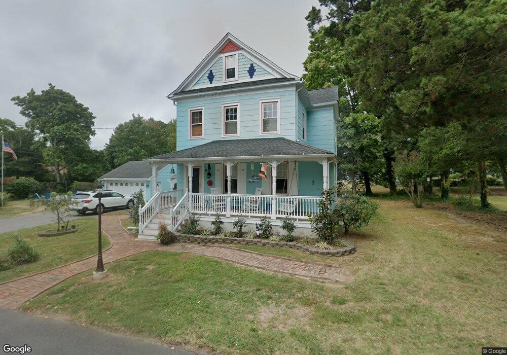
9 Stearns Ave Atlantic Highlands, NJ 07716
Estimated Value: $736,000 - $782,000
3
Beds
2
Baths
1,376
Sq Ft
$549/Sq Ft
Est. Value
About This Home
This home is located at 9 Stearns Ave, Atlantic Highlands, NJ 07716 and is currently estimated at $755,193, approximately $548 per square foot. 9 Stearns Ave is a home located in Monmouth County with nearby schools including Navesink Elementary School, Bayshore Middle School, and Middletown - South High School.
Ownership History
Date
Name
Owned For
Owner Type
Purchase Details
Closed on
Dec 17, 2010
Sold by
Maxson Harry A
Bought by
Allen Barbara P and Allen Elizabeth
Current Estimated Value
Home Financials for this Owner
Home Financials are based on the most recent Mortgage that was taken out on this home.
Original Mortgage
$335,279
Outstanding Balance
$235,469
Interest Rate
5.5%
Mortgage Type
FHA
Estimated Equity
$519,724
Create a Home Valuation Report for This Property
The Home Valuation Report is an in-depth analysis detailing your home's value as well as a comparison with similar homes in the area
Home Values in the Area
Average Home Value in this Area
Purchase History
| Date | Buyer | Sale Price | Title Company |
|---|---|---|---|
| Allen Barbara P | $344,000 | Red Bank Title Agency Inc |
Source: Public Records
Mortgage History
| Date | Status | Borrower | Loan Amount |
|---|---|---|---|
| Open | Allen Barbara P | $335,279 |
Source: Public Records
Tax History
| Year | Tax Paid | Tax Assessment Tax Assessment Total Assessment is a certain percentage of the fair market value that is determined by local assessors to be the total taxable value of land and additions on the property. | Land | Improvement |
|---|---|---|---|---|
| 2025 | $11,022 | $768,200 | $527,500 | $240,700 |
| 2024 | $11,387 | $670,000 | $433,800 | $236,200 |
| 2023 | $11,387 | $655,200 | $412,900 | $242,300 |
| 2022 | $9,915 | $527,200 | $296,500 | $230,700 |
| 2021 | $9,915 | $476,700 | $271,500 | $205,200 |
| 2020 | $7,947 | $371,700 | $237,500 | $134,200 |
| 2019 | $7,833 | $370,900 | $237,500 | $133,400 |
| 2018 | $7,686 | $354,700 | $227,500 | $127,200 |
| 2017 | $7,830 | $357,700 | $227,500 | $130,200 |
| 2016 | $7,510 | $352,400 | $212,500 | $139,900 |
| 2015 | $7,766 | $351,900 | $212,500 | $139,400 |
| 2014 | $7,692 | $339,900 | $212,500 | $127,400 |
Source: Public Records
Map
Nearby Homes
- 96 East Ave Unit 82
- 96 East Ave Unit 76
- 96 East Ave Unit 97
- 498 Central Ave
- 502 Central Ave
- 500 Central Ave
- 7100 Prospect Ave
- 6998 Prospect Ave
- 26 King James Ln
- 96 E East Ave Unit 37
- 9 King James Ln
- 114 Memorial Pkwy
- 254 1st Ave
- 50 Memorial Pkwy
- 19 Summit Ave
- 119 Chestnut Ave
- 104 E Washington Ave
- 16 E Garfield Ave
- 12 E Garfield Ave
- 8 E Garfield Ave
- 10 Meadowbrook Ave
- 15 Stearns Ave
- 6 Stearns Ave
- 8 Meadowbrook Ave
- 10 Stearns Ave
- 202 Monmouth Ave
- 14 Meadowbrook Ave
- 200 Monmouth Ave
- 198 Monmouth Ave
- 204 Monmouth Ave
- 16 Meadowbrook Ave
- 20 Stearns Ave
- 20 Stearns Ave
- 20 Meadowbrook Ave
- 196 Monmouth Ave
- 21 Stearns Ave
- 7 Meadowbrook Ave
- 0 Stearns Ave Unit 22226493
- 0 Stearns Ave Unit 22217909
- 22 Meadowbrook Ave
Your Personal Tour Guide
Ask me questions while you tour the home.