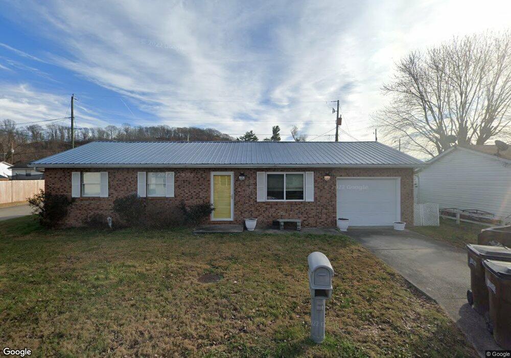
9 Twp Rd 1408 S South Point, OH 45680
Clearview NeighborhoodEstimated Value: $144,000 - $166,000
3
Beds
1
Bath
1,040
Sq Ft
$146/Sq Ft
Est. Value
About This Home
This home is located at 9 Twp Rd 1408 S, South Point, OH 45680 and is currently estimated at $151,667, approximately $145 per square foot. 9 Twp Rd 1408 S is a home with nearby schools including South Point High School.
Ownership History
Date
Name
Owned For
Owner Type
Purchase Details
Closed on
Feb 24, 2011
Sold by
Powell Melissa D and Elliott Gary
Bought by
Powell Nathan and Powell Melissa D
Current Estimated Value
Home Financials for this Owner
Home Financials are based on the most recent Mortgage that was taken out on this home.
Original Mortgage
$55,240
Outstanding Balance
$38,399
Interest Rate
5.04%
Mortgage Type
New Conventional
Estimated Equity
$113,268
Purchase Details
Closed on
Sep 11, 2002
Sold by
Zornes Grace E
Bought by
Powell Melissa D and Powell Gary
Create a Home Valuation Report for This Property
The Home Valuation Report is an in-depth analysis detailing your home's value as well as a comparison with similar homes in the area
Home Values in the Area
Average Home Value in this Area
Purchase History
| Date | Buyer | Sale Price | Title Company |
|---|---|---|---|
| Powell Nathan | -- | None Available | |
| Powell Melissa D | $59,900 | -- |
Source: Public Records
Mortgage History
| Date | Status | Borrower | Loan Amount |
|---|---|---|---|
| Open | Powell Nathan | $55,240 |
Source: Public Records
Tax History Compared to Growth
Tax History
| Year | Tax Paid | Tax Assessment Tax Assessment Total Assessment is a certain percentage of the fair market value that is determined by local assessors to be the total taxable value of land and additions on the property. | Land | Improvement |
|---|---|---|---|---|
| 2024 | -- | $33,050 | $5,230 | $27,820 |
| 2023 | $995 | $33,050 | $5,230 | $27,820 |
| 2022 | $992 | $33,050 | $5,230 | $27,820 |
| 2021 | $838 | $27,060 | $3,480 | $23,580 |
| 2020 | $852 | $27,060 | $3,480 | $23,580 |
| 2019 | $848 | $27,060 | $3,480 | $23,580 |
| 2018 | $833 | $26,240 | $3,480 | $22,760 |
| 2017 | $832 | $26,240 | $3,480 | $22,760 |
| 2016 | $771 | $26,240 | $3,480 | $22,760 |
| 2015 | $746 | $23,920 | $3,480 | $20,440 |
| 2014 | $745 | $23,920 | $3,480 | $20,440 |
| 2013 | $743 | $23,920 | $3,480 | $20,440 |
Source: Public Records
Map
Nearby Homes
- 0 Township Road 161 Unit 182331
- 1225 County Road 15
- 2904 County Road 1
- 719 County Road 15
- 119 County Road 15
- 905 Honeysuckle Ln
- 314 Wadkins St
- 110 Kitts Ln
- 614 Gartrell St
- 0 E Ridge St
- 823 Birch St
- 4863 Richardson Rd
- 102 Park Ave
- 5114 Blackburn Ave
- 5023 King Richard Ct
- 108 Ferry St
- 0 Wallace St
- 3421 Central Ave
- 3907 Avery St
- 0 County Road 1
- 21 Township Road 1408 N
- 51 Township Road 1467
- 10 Twp Rd 1408 S
- 10 Township Road 1408 N
- 37 Township Road 1467
- 22 Twp Rd 1408 S
- 71 Township Road 1467
- 11 Township Road 1408 N
- 1408 N Ann St
- 24 Twp Rd 1408 N
- 85 Township Road 1467
- 48 Tr 510 N
- 25 Twp Rd 1408 N
- 13 Township Road 1467
- 38 Township Road 1408 N
- 173 Top St Unit 616
- 97 Township Road 1467
- 37 Twp Rd 1408 N
- 37 Township Road 1408 N
- 0 Township Road 508 Unit LAO-3