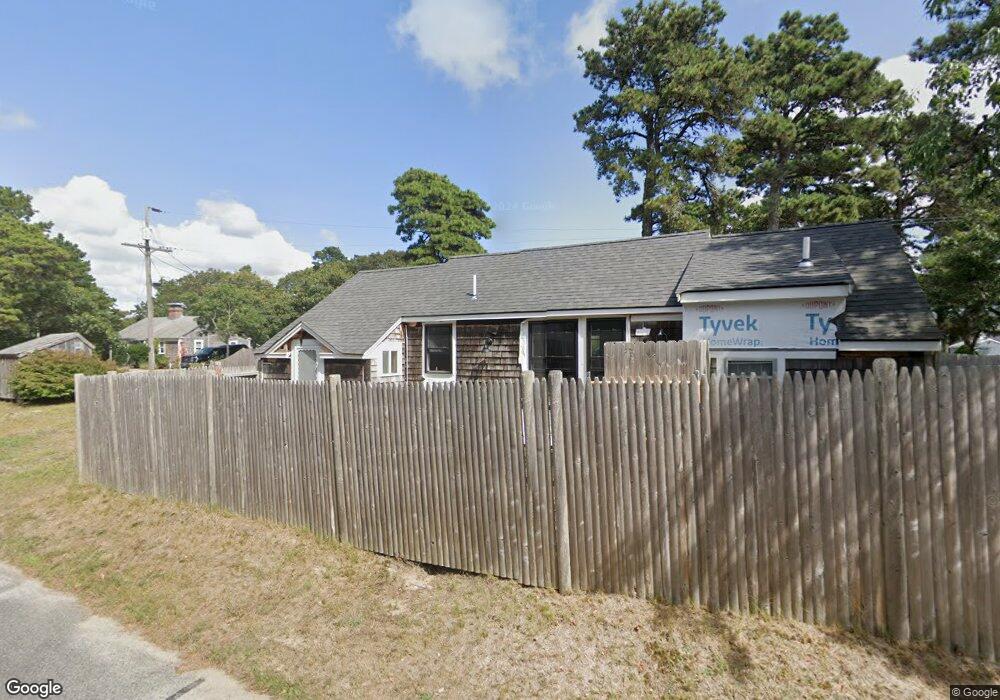
9 Uncle Ezras Path Dennis Port, MA 02639
Dennis Port NeighborhoodEstimated Value: $323,000 - $483,751
2
Beds
1
Bath
674
Sq Ft
$580/Sq Ft
Est. Value
About This Home
This home is located at 9 Uncle Ezras Path, Dennis Port, MA 02639 and is currently estimated at $390,938, approximately $580 per square foot. 9 Uncle Ezras Path is a home located in Barnstable County with nearby schools including Dennis-Yarmouth Regional High School and St. Pius X. School.
Ownership History
Date
Name
Owned For
Owner Type
Purchase Details
Closed on
Oct 31, 2019
Sold by
Leclair Marilyn C
Bought by
Rouleau William
Current Estimated Value
Home Financials for this Owner
Home Financials are based on the most recent Mortgage that was taken out on this home.
Original Mortgage
$112,500
Outstanding Balance
$99,167
Interest Rate
3.7%
Mortgage Type
New Conventional
Estimated Equity
$291,771
Purchase Details
Closed on
Jun 18, 1979
Bought by
Leclair Alfred A and Leclair Marilyn C
Create a Home Valuation Report for This Property
The Home Valuation Report is an in-depth analysis detailing your home's value as well as a comparison with similar homes in the area
Home Values in the Area
Average Home Value in this Area
Purchase History
| Date | Buyer | Sale Price | Title Company |
|---|---|---|---|
| Rouleau William | $150,000 | -- | |
| Leclair Alfred A | -- | -- |
Source: Public Records
Mortgage History
| Date | Status | Borrower | Loan Amount |
|---|---|---|---|
| Open | Rouleau William | $112,500 |
Source: Public Records
Tax History Compared to Growth
Tax History
| Year | Tax Paid | Tax Assessment Tax Assessment Total Assessment is a certain percentage of the fair market value that is determined by local assessors to be the total taxable value of land and additions on the property. | Land | Improvement |
|---|---|---|---|---|
| 2025 | $1,622 | $374,500 | $161,800 | $212,700 |
| 2024 | $1,481 | $337,300 | $155,600 | $181,700 |
| 2023 | $1,432 | $306,700 | $141,400 | $165,300 |
| 2022 | $1,399 | $249,800 | $127,400 | $122,400 |
| 2021 | $1,459 | $242,000 | $142,700 | $99,300 |
| 2020 | $1,312 | $215,100 | $124,900 | $90,200 |
| 2019 | $1,251 | $202,700 | $122,500 | $80,200 |
| 2018 | $1,196 | $188,600 | $116,600 | $72,000 |
| 2017 | $1,094 | $177,900 | $108,200 | $69,700 |
| 2016 | $1,146 | $175,500 | $116,600 | $58,900 |
| 2015 | $1,123 | $175,500 | $116,600 | $58,900 |
| 2014 | $1,008 | $158,800 | $99,900 | $58,900 |
Source: Public Records
Map
Nearby Homes
- 31 Easy St
- 80 Michaels Ave
- 22 Wixon Rd
- 64 Beaten Rd
- 37 Ocean Dr Unit 2
- 19 Standish Way
- 37 Beach Hills Rd
- 262 Old Wharf Rd Unit 67
- 262 Old Wharf Rd Unit 5
- 262 Old Wharf Rd Unit 5
- 262 Old Wharf Rd Unit 20
- 262 Old Wharf Rd Unit 87
- 37-A Beach Hills Rd
- 154 Old Wharf Rd Unit 26
- 154 Old Wharf Rd Unit 14
- 22 Ferncliff Rd
- 217 Old Wharf Rd Unit 64
- 241 Old Wharf Rd Unit 82
- 241 Old Wharf Rd Unit 127
- 241 Old Wharf Rd Unit 90
- 13 Uncle Ezras Path
- 87 Captain Chase Rd
- 16 Uncle Ezras Path
- 85 Captain Chase Rd
- 12 Uncle Ezras Path
- 91 Captain Chase Rd
- 81 Captain Chase Rd
- 17 Uncle Ezras Path
- 8 Uncle Ezras Path
- 9 Lorree Ln
- 93 Captain Chase Rd
- 79 Captain Chase Rd
- 11 Lorree Ln
- 5 Lorree Ln
- 19 Uncle Ezras Path
- 17 Lorree Ln
- 0 Uncle Toms Path
- 96 Captain Chase Rd
- 97 Captain Chase Rd
- 75 Captain Chase Rd