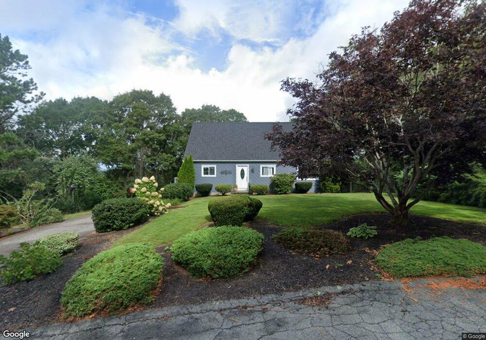
9 Westerly Dr Bourne, MA 2532
Monument Beach NeighborhoodEstimated Value: $613,995 - $742,000
3
Beds
2
Baths
1,586
Sq Ft
$416/Sq Ft
Est. Value
About This Home
This home is located at 9 Westerly Dr, Bourne, MA 2532 and is currently estimated at $659,249, approximately $415 per square foot. 9 Westerly Dr is a home located in Barnstable County with nearby schools including Bourne High School, Cadence Academy Preschool - Bourne, and St Margaret Regional School.
Ownership History
Date
Name
Owned For
Owner Type
Purchase Details
Closed on
Jan 8, 2021
Sold by
G William Eldridge Lt and Eldridge
Bought by
Campbell Patia
Current Estimated Value
Purchase Details
Closed on
Aug 10, 2020
Sold by
Eldridge George W
Bought by
G William Eldridge Lt and Eldridge
Home Financials for this Owner
Home Financials are based on the most recent Mortgage that was taken out on this home.
Original Mortgage
$429,725
Interest Rate
3.1%
Mortgage Type
VA
Purchase Details
Closed on
Jul 7, 2020
Sold by
Dhedouville Eric F and Corbo Cindy M
Bought by
Eldridge George W
Home Financials for this Owner
Home Financials are based on the most recent Mortgage that was taken out on this home.
Original Mortgage
$429,725
Interest Rate
3.1%
Mortgage Type
VA
Purchase Details
Closed on
Sep 9, 2019
Sold by
House2home Real Estate
Bought by
Corbo Cindy M and Dhedouville Eric F
Home Financials for this Owner
Home Financials are based on the most recent Mortgage that was taken out on this home.
Original Mortgage
$402,475
Interest Rate
3.7%
Mortgage Type
FHA
Purchase Details
Closed on
Dec 22, 2018
Sold by
Winter Rt and Attuck Llc Tr
Bought by
House2home Real Estate
Home Financials for this Owner
Home Financials are based on the most recent Mortgage that was taken out on this home.
Original Mortgage
$267,125
Interest Rate
4.8%
Mortgage Type
Commercial
Purchase Details
Closed on
Nov 13, 2018
Sold by
Fox Eleanor and Lakeview Loan Svcg Llc
Bought by
Winter Rt and Attuck Llc Tr
Home Financials for this Owner
Home Financials are based on the most recent Mortgage that was taken out on this home.
Original Mortgage
$267,125
Interest Rate
4.8%
Mortgage Type
Commercial
Purchase Details
Closed on
Jun 26, 2015
Sold by
Scudder John A and Scudder Jane T
Bought by
Fox Eleanor
Home Financials for this Owner
Home Financials are based on the most recent Mortgage that was taken out on this home.
Original Mortgage
$270,019
Interest Rate
3.75%
Mortgage Type
FHA
Purchase Details
Closed on
Oct 27, 2000
Sold by
Jeffries James A and Jeffries Amanda P
Bought by
Scudder John A and Scudder Janet T
Purchase Details
Closed on
Aug 30, 1993
Sold by
Rw Anderson Inc
Bought by
Hodkinson Stanley W
Create a Home Valuation Report for This Property
The Home Valuation Report is an in-depth analysis detailing your home's value as well as a comparison with similar homes in the area
Home Values in the Area
Average Home Value in this Area
Purchase History
| Date | Buyer | Sale Price | Title Company |
|---|---|---|---|
| Campbell Patia | $442,000 | None Available | |
| Campbell Patia | $442,000 | None Available | |
| G William Eldridge Lt | -- | None Available | |
| G William Eldridge Lt | -- | None Available | |
| Eldridge George W | $445,000 | None Available | |
| Eldridge George W | $445,000 | None Available | |
| Corbo Cindy M | $409,900 | -- | |
| Corbo Cindy M | $409,900 | -- | |
| House2home Real Estate | $243,500 | -- | |
| House2home Real Estate | $243,500 | -- | |
| Winter Rt | $223,500 | -- | |
| Winter Rt | $223,500 | -- | |
| Fox Eleanor | $275,000 | -- | |
| Fox Eleanor | $275,000 | -- | |
| Scudder John A | $184,000 | -- | |
| Scudder John A | $184,000 | -- | |
| Hodkinson Stanley W | $35,000 | -- | |
| Hodkinson Stanley W | $35,000 | -- | |
| Hodkinson Stanley W | $35,000 | -- |
Source: Public Records
Mortgage History
| Date | Status | Borrower | Loan Amount |
|---|---|---|---|
| Previous Owner | Eldridge George W | $429,725 | |
| Previous Owner | Corbo Cindy M | $402,475 | |
| Previous Owner | House2home Real Estate | $267,125 | |
| Previous Owner | Fox Eleanor | $270,019 | |
| Previous Owner | Hodkinson Stanley W | $138,000 |
Source: Public Records
Tax History
| Year | Tax Paid | Tax Assessment Tax Assessment Total Assessment is a certain percentage of the fair market value that is determined by local assessors to be the total taxable value of land and additions on the property. | Land | Improvement |
|---|---|---|---|---|
| 2025 | $4,463 | $571,500 | $201,600 | $369,900 |
| 2024 | $4,364 | $544,200 | $192,000 | $352,200 |
| 2023 | $4,242 | $481,500 | $169,900 | $311,600 |
| 2022 | $4,483 | $444,300 | $150,400 | $293,900 |
| 2021 | $3,981 | $369,600 | $136,800 | $232,800 |
| 2020 | $3,741 | $348,300 | $135,500 | $212,800 |
| 2019 | $3,231 | $307,400 | $135,500 | $171,900 |
| 2018 | $3,086 | $292,800 | $129,100 | $163,700 |
| 2017 | $2,880 | $279,600 | $121,500 | $158,100 |
| 2016 | $2,512 | $247,200 | $121,500 | $125,700 |
| 2015 | $2,360 | $234,400 | $108,700 | $125,700 |
Source: Public Records
Map
Nearby Homes
- 4 Harbor Hill Dr
- 20 Colony Ave
- 16 Amberwood Ct
- 12 Turnberry Rd Unit 12
- 4 Hollyhock Knoll Ct Unit 4
- 4 Hollyhock Knoll Ct Unit 4
- 203 County Rd
- 5 Sea Knoll Ct
- 13 Laurel Hill Ct
- 5 Zoli Ln
- 566 Shore Rd
- 44 Cotuit Rd
- 10 Sandy Ln
- 3 1st St
- 709 County Rd
- 60 Sandwich Rd
- 7 4th Ave
- 3 4th Ave
- 254 Barlows Landing Rd
- 14 Navajo Rd
Your Personal Tour Guide
Ask me questions while you tour the home.