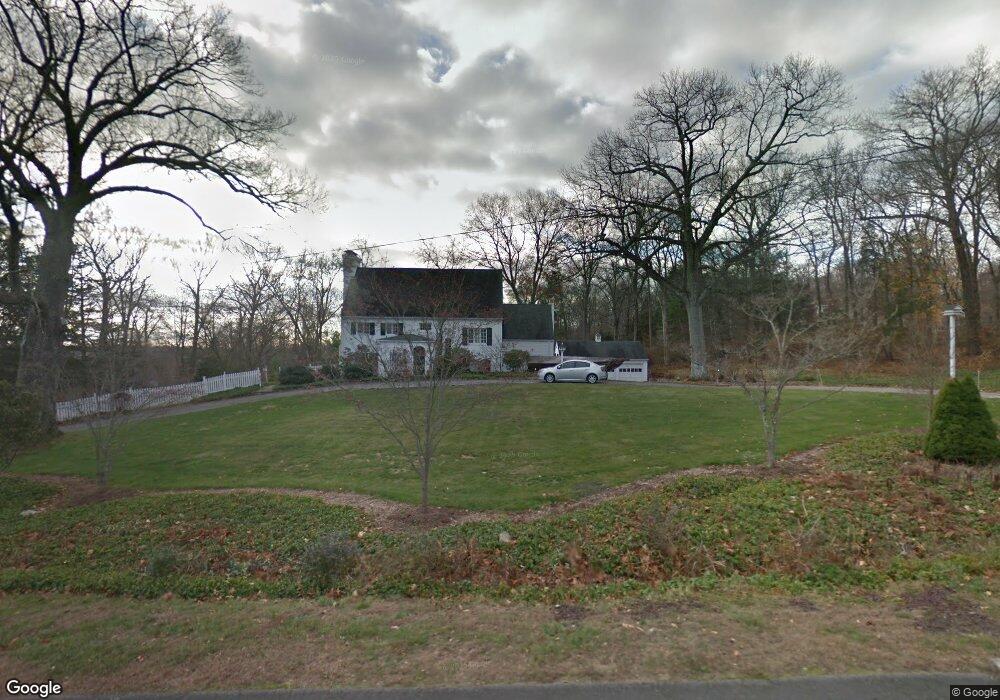
9 Woodway Ln Wilton, CT 06897
Estimated Value: $1,909,317 - $2,210,000
4
Beds
4
Baths
3,741
Sq Ft
$537/Sq Ft
Est. Value
About This Home
This home is located at 9 Woodway Ln, Wilton, CT 06897 and is currently estimated at $2,009,829, approximately $537 per square foot. 9 Woodway Ln is a home located in Fairfield County with nearby schools including Miller-Driscoll School, Cider Mill School, and Middlebrook School.
Ownership History
Date
Name
Owned For
Owner Type
Purchase Details
Closed on
Nov 6, 2020
Sold by
Wood Margaret E
Bought by
Margaret E Wood Ret
Current Estimated Value
Purchase Details
Closed on
Jan 21, 2004
Sold by
Tevis Patricia D
Bought by
Wood Margaret E
Purchase Details
Closed on
Sep 2, 1988
Sold by
Lauber Raymond
Bought by
Tevis Terry
Create a Home Valuation Report for This Property
The Home Valuation Report is an in-depth analysis detailing your home's value as well as a comparison with similar homes in the area
Home Values in the Area
Average Home Value in this Area
Purchase History
| Date | Buyer | Sale Price | Title Company |
|---|---|---|---|
| Margaret E Wood Ret | -- | None Available | |
| Wood Margaret E | $1,390,000 | -- | |
| Tevis Terry | $755,000 | -- |
Source: Public Records
Mortgage History
| Date | Status | Borrower | Loan Amount |
|---|---|---|---|
| Previous Owner | Tevis Terry | $636,088 | |
| Previous Owner | Tevis Terry | $708,750 |
Source: Public Records
Tax History Compared to Growth
Tax History
| Year | Tax Paid | Tax Assessment Tax Assessment Total Assessment is a certain percentage of the fair market value that is determined by local assessors to be the total taxable value of land and additions on the property. | Land | Improvement |
|---|---|---|---|---|
| 2025 | $24,004 | $983,360 | $369,740 | $613,620 |
| 2024 | $23,542 | $983,360 | $369,740 | $613,620 |
| 2023 | $19,470 | $665,420 | $338,870 | $326,550 |
| 2022 | $18,785 | $665,420 | $338,870 | $326,550 |
| 2021 | $18,545 | $665,420 | $338,870 | $326,550 |
| 2020 | $18,272 | $665,420 | $338,870 | $326,550 |
| 2019 | $18,991 | $665,420 | $338,870 | $326,550 |
| 2018 | $19,457 | $690,200 | $356,580 | $333,620 |
| 2017 | $19,167 | $690,200 | $356,580 | $333,620 |
| 2016 | $18,870 | $690,200 | $356,580 | $333,620 |
| 2015 | $18,518 | $690,200 | $356,580 | $333,620 |
| 2014 | $18,297 | $690,200 | $356,580 | $333,620 |
Source: Public Records
Map
Nearby Homes
- 93 E Meadow Rd
- 4A Newtown Turnpike
- 25 Hermit Ln
- 30 Cavalry Rd
- 10 Wilton Hunt Rd
- 6 Tulip Tree Ln
- 4 Good Hill Rd
- 17 Huckleberry Ln
- 31 Riverfield Dr
- 87 Red Coat Rd
- 29 Grumman Ave
- 110 Dudley Rd
- 10 Twin Falls Ln
- 32 Kettle Creek Rd
- 32 Thistle Rd
- 259 Wilton Rd
- 28 Village Ct
- 4 Newtown Turnpike
- 56 Partrick Rd
- 105 Danbury Rd
- 15 E Meadow Rd
- 8 Woodway Ln
- 11 Woodway Ln
- 11 E Meadow Rd
- 10 Woodway Ln
- 2 E Meadow Rd
- 23 E Meadow Rd
- 13 Woodway Ln
- 83 W Meadow Rd
- 93 W Meadow Rd
- 40 Mollbrook Dr
- 40 E Meadow Rd
- 6 Barn Swallow Dr
- 50 Mollbrook Dr
- 105 W Meadow Rd
- 48 Mollbrook Dr
- 47 E Meadow Rd
- 46 Mollbrook Dr
- 71 W Meadow Rd
- 14 Woodway Ln