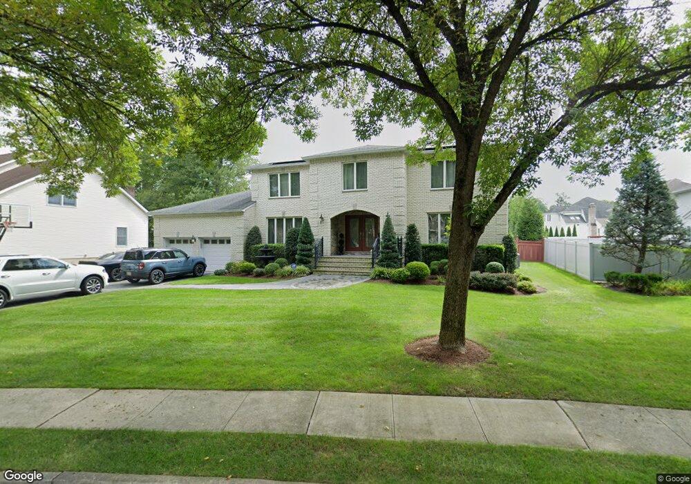
90 Andrea Ct Paramus, NJ 07652
Estimated Value: $1,544,000 - $2,086,000
Studio
--
Bath
3,616
Sq Ft
$478/Sq Ft
Est. Value
About This Home
This home is located at 90 Andrea Ct, Paramus, NJ 07652 and is currently estimated at $1,726,756, approximately $477 per square foot. 90 Andrea Ct is a home located in Bergen County with nearby schools including Paramus High School, Ben Porat Yosef, and St. Peter Academy.
Ownership History
Date
Name
Owned For
Owner Type
Purchase Details
Closed on
Apr 29, 2005
Sold by
Maher Diane
Bought by
Michaud Christopher and Michaud Olga
Current Estimated Value
Purchase Details
Closed on
Apr 12, 1999
Sold by
Maher Steven and Maher Diane
Bought by
Maher Diane
Purchase Details
Closed on
Jun 28, 1994
Sold by
Howland Forest Inc
Bought by
Maher Samuel and Maher Mildred
Home Financials for this Owner
Home Financials are based on the most recent Mortgage that was taken out on this home.
Original Mortgage
$279,000
Interest Rate
8.55%
Create a Home Valuation Report for This Property
The Home Valuation Report is an in-depth analysis detailing your home's value as well as a comparison with similar homes in the area
Home Values in the Area
Average Home Value in this Area
Purchase History
We collect this data history from publicly available records. To have your information removed, we recommend requesting removal directly through your county’s website.
| Date | Buyer | Sale Price | Title Company |
|---|---|---|---|
| Michaud Christopher | $1,075,000 | -- | |
| Maher Diane | -- | -- | |
| Maher Samuel | $465,000 | -- |
Source: Public Records
Mortgage History
We collect this data history from publicly available records. To have your information removed, we recommend requesting removal directly through your county’s website.
| Date | Status | Borrower | Loan Amount |
|---|---|---|---|
| Previous Owner | Maher Samuel | $279,000 |
Source: Public Records
Tax History
| Year | Tax Paid | Tax Assessment Tax Assessment Total Assessment is a certain percentage of the fair market value that is determined by local assessors to be the total taxable value of land and additions on the property. | Land | Improvement |
|---|---|---|---|---|
| 2025 | $19,841 | $1,389,900 | $417,300 | $972,600 |
| 2024 | $19,295 | $1,310,500 | $386,100 | $924,400 |
| 2023 | $18,307 | $1,257,800 | $367,900 | $889,900 |
| 2022 | $18,307 | $1,179,600 | $343,200 | $836,400 |
| 2021 | $17,428 | $1,053,700 | $317,000 | $736,700 |
| 2020 | $16,550 | $1,037,600 | $312,000 | $725,600 |
| 2019 | $16,398 | $883,500 | $362,900 | $520,600 |
| 2018 | $16,195 | $883,500 | $362,900 | $520,600 |
| 2017 | $15,734 | $873,600 | $362,900 | $510,700 |
| 2016 | $15,305 | $873,600 | $362,900 | $510,700 |
| 2015 | $15,148 | $873,600 | $362,900 | $510,700 |
| 2014 | $15,017 | $873,600 | $362,900 | $510,700 |
Source: Public Records
Map
Nearby Homes
- 144 Village Cir E
- 56 Lilac Ln
- 66 Knollwood Dr
- 46 Knollwood Dr
- 81 Eastbrook Dr
- 189 Forest Ave Unit 307
- 189 Forest Ave Unit 108
- 189 Forest Ave Unit 317
- 189 Forest Ave Unit 216
- 189 Forest Ave Unit 112
- 339 5th Ave
- 405 Valley Rd
- 252 Valley Rd
- 302 Howland Ave
- 21A Millar Ct
- 16 Coles Ct
- 203 Lawrence Dr
- 177 Lawson Place
- 283 Taft Rd
- 4 Schubert Ln
Your Personal Tour Guide
Ask me questions while you tour the home.