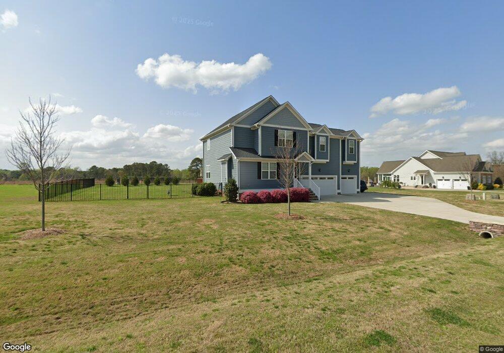
90 Brookstone Way Unit 64 Angier, NC 27501
Pleasant Grove NeighborhoodEstimated Value: $430,948 - $497,000
4
Beds
3
Baths
2,459
Sq Ft
$186/Sq Ft
Est. Value
About This Home
This home is located at 90 Brookstone Way Unit 64, Angier, NC 27501 and is currently estimated at $457,737, approximately $186 per square foot. 90 Brookstone Way Unit 64 is a home located in Johnston County with nearby schools including McGee's Crossroads Elementary School, McGee's Crossroads Middle School, and West Johnston High School.
Ownership History
Date
Name
Owned For
Owner Type
Purchase Details
Closed on
Sep 2, 2022
Sold by
Marie Anderson and Marie Bailee
Bought by
Romero Mario D
Current Estimated Value
Home Financials for this Owner
Home Financials are based on the most recent Mortgage that was taken out on this home.
Original Mortgage
$346,500
Outstanding Balance
$330,366
Interest Rate
5%
Mortgage Type
New Conventional
Estimated Equity
$127,371
Purchase Details
Closed on
Dec 2, 2020
Sold by
Mohler Homes Inc
Bought by
Anderson Levi and Anderson Bailee Marie
Home Financials for this Owner
Home Financials are based on the most recent Mortgage that was taken out on this home.
Original Mortgage
$278,920
Interest Rate
2.8%
Mortgage Type
New Conventional
Purchase Details
Closed on
Sep 19, 2019
Sold by
Deana Manning Realty Llc
Bought by
Mohler Homes Inc
Home Financials for this Owner
Home Financials are based on the most recent Mortgage that was taken out on this home.
Original Mortgage
$3,000,000
Interest Rate
3.6%
Mortgage Type
Future Advance Clause Open End Mortgage
Purchase Details
Closed on
Apr 1, 2015
Sold by
Manning Jerry Christopher and Manning Deana Len
Bought by
Deana Manning Realty Llc
Home Financials for this Owner
Home Financials are based on the most recent Mortgage that was taken out on this home.
Original Mortgage
$170,000
Interest Rate
3.87%
Mortgage Type
Future Advance Clause Open End Mortgage
Purchase Details
Closed on
Apr 28, 2014
Sold by
Nc Properties I Llc
Bought by
Manning Chris
Home Financials for this Owner
Home Financials are based on the most recent Mortgage that was taken out on this home.
Original Mortgage
$365,765
Interest Rate
4.43%
Mortgage Type
New Conventional
Purchase Details
Closed on
Sep 30, 2010
Sold by
Crm Mid Atlantic Properties Llc
Bought by
Nc Properties I Llc
Purchase Details
Closed on
Sep 10, 2009
Sold by
Marcus Edwards Development Llc
Bought by
Crm Mid Atlantic Properties Llc
Create a Home Valuation Report for This Property
The Home Valuation Report is an in-depth analysis detailing your home's value as well as a comparison with similar homes in the area
Home Values in the Area
Average Home Value in this Area
Purchase History
| Date | Buyer | Sale Price | Title Company |
|---|---|---|---|
| Romero Mario D | $385,000 | -- | |
| Anderson Levi | $294,000 | None Available | |
| Anderson Levi | $294,000 | None Listed On Document | |
| Mohler Homes Inc | $130,000 | None Available | |
| Deana Manning Realty Llc | -- | None Available | |
| Manning Chris | $347,000 | None Available | |
| Nc Properties I Llc | $121,500 | None Available | |
| Crm Mid Atlantic Properties Llc | $577,500 | None Available |
Source: Public Records
Mortgage History
| Date | Status | Borrower | Loan Amount |
|---|---|---|---|
| Open | Romero Mario D | $346,500 | |
| Previous Owner | Anderson Levi | $278,920 | |
| Previous Owner | Mohler Homes Inc | $3,000,000 | |
| Previous Owner | Deana Manning Realty Llc | $170,000 | |
| Previous Owner | Manning Chris | $365,765 |
Source: Public Records
Tax History
| Year | Tax Paid | Tax Assessment Tax Assessment Total Assessment is a certain percentage of the fair market value that is determined by local assessors to be the total taxable value of land and additions on the property. | Land | Improvement |
|---|---|---|---|---|
| 2025 | $2,763 | $435,110 | $70,000 | $365,110 |
| 2024 | $2,203 | $271,930 | $36,000 | $235,930 |
| 2023 | $2,135 | $271,930 | $36,000 | $235,930 |
| 2022 | $2,221 | $271,930 | $36,000 | $235,930 |
| 2021 | $2,203 | $271,930 | $36,000 | $235,930 |
| 2020 | $302 | $36,000 | $36,000 | $0 |
| 2019 | $295 | $36,000 | $36,000 | $0 |
| 2018 | $336 | $40,000 | $40,000 | $0 |
| 2017 | $336 | $40,000 | $40,000 | $0 |
| 2016 | $336 | $40,000 | $40,000 | $0 |
| 2015 | $336 | $40,000 | $40,000 | $0 |
| 2014 | $336 | $40,000 | $40,000 | $0 |
Source: Public Records
Map
Nearby Homes
- 197 Silverside Dr
- 16 Keystone Ct
- 15973 N Carolina 210
- 2821 Old Fairground Rd
- 105 Pinecrest Dr
- 124 Highland Dr
- 506 Harbor Cove Dr
- 64 Abilene Ct
- 810 | 850 Wiggins Rd
- 71 Suzanne Dr
- 205 Teresa Ct
- 111 Edmund Dr
- 3002 Red Cir
- 120 S Bream Ct Unit Lot 8
- 264 Harbor Cove Dr
- 106 S Bream Ct Unit Lot 10
- 106 S Bream Ct
- 115 S Bream Ct
- 115 S Bream Ct Unit Lot 6
- 2004 Little Pond Place
- 90 Brookstone Way
- 124 Brookstone Way Unit 63
- 42 Brookstone Way
- 85 Brookstone Way
- 109 Brookstone Way
- 53 Brookstone Way
- 162 Brookstone Way
- 25 Brookstone Way
- 318 Brookstone Way
- 169 Brookstone Way
- 169 Brookstone Way Unit 6
- 318 Brookstone Way Unit 56
- 328 Brookstone Way Unit 55
- 328 Brookstone Way
- 0 Brookstone Way
- 196 Brookstone Way
- 196 Brookstone Way Unit 61
- 45 Ivy Hollow Ct
- 45 Ivy Hollow Ct Unit 8
- 53 Ivy Hollow Ct
Your Personal Tour Guide
Ask me questions while you tour the home.