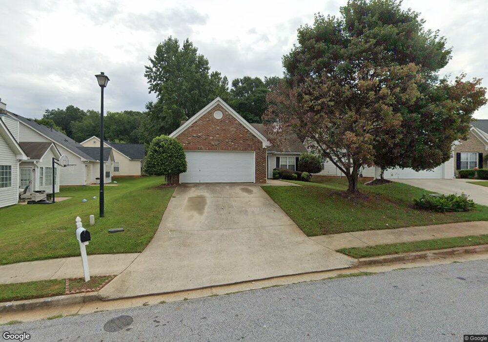
90 Collins Trace Covington, GA 30016
Estimated Value: $239,736 - $252,000
3
Beds
2
Baths
1,420
Sq Ft
$173/Sq Ft
Est. Value
About This Home
This home is located at 90 Collins Trace, Covington, GA 30016 and is currently estimated at $246,184, approximately $173 per square foot. 90 Collins Trace is a home located in Newton County with nearby schools including West Newton Elementary School, Veterans Memorial Middle School, and Alcovy High School.
Ownership History
Date
Name
Owned For
Owner Type
Purchase Details
Closed on
Jan 30, 2012
Sold by
Deutsche Bank National Tru
Bought by
Simms Gene
Current Estimated Value
Purchase Details
Closed on
Nov 1, 2011
Sold by
Barker Debra I
Bought by
Deutsche Bank National Trust C and C/O Pmos Llc Etal
Purchase Details
Closed on
Apr 29, 2004
Sold by
Mnw Const Co
Bought by
Barker Debra I
Home Financials for this Owner
Home Financials are based on the most recent Mortgage that was taken out on this home.
Original Mortgage
$121,761
Interest Rate
5.36%
Mortgage Type
VA
Create a Home Valuation Report for This Property
The Home Valuation Report is an in-depth analysis detailing your home's value as well as a comparison with similar homes in the area
Home Values in the Area
Average Home Value in this Area
Purchase History
| Date | Buyer | Sale Price | Title Company |
|---|---|---|---|
| Simms Gene | $37,999 | -- | |
| Deutsche Bank National Trust C | $50,000 | -- | |
| Barker Debra I | $123,700 | -- |
Source: Public Records
Mortgage History
| Date | Status | Borrower | Loan Amount |
|---|---|---|---|
| Previous Owner | Barker Debra I | $121,761 |
Source: Public Records
Tax History
| Year | Tax Paid | Tax Assessment Tax Assessment Total Assessment is a certain percentage of the fair market value that is determined by local assessors to be the total taxable value of land and additions on the property. | Land | Improvement |
|---|---|---|---|---|
| 2025 | $2,682 | $105,480 | $16,000 | $89,480 |
| 2024 | $2,622 | $101,240 | $16,000 | $85,240 |
| 2023 | $2,831 | $102,200 | $7,200 | $95,000 |
| 2022 | $2,099 | $75,240 | $7,200 | $68,040 |
| 2021 | $1,788 | $57,080 | $7,200 | $49,880 |
| 2020 | $1,741 | $50,160 | $7,200 | $42,960 |
| 2019 | $1,756 | $49,840 | $7,200 | $42,640 |
| 2018 | $750 | $42,040 | $4,800 | $37,240 |
| 2017 | $1,432 | $40,080 | $4,800 | $35,280 |
| 2016 | $1,340 | $37,400 | $3,800 | $33,600 |
| 2015 | $1,066 | $29,440 | $3,400 | $26,040 |
| 2014 | $1,014 | $28,040 | $0 | $0 |
Source: Public Records
Map
Nearby Homes
- 20 Greenway Dr
- 80 Greenway Dr
- 35 Springfield Way
- 110 Greenway Dr
- 60 Templeton Way
- 225 Dairyland Dr
- 215 Middleton Dr
- 135 Timberlake Terrace
- 185 Hazelhurst Dr
- 45 Somerset Ct
- 30 Freedom Ct
- 35 Charity Chase
- 55 Emerson Trail
- 45 Sunset Ct
- 30 Emerson Trail
- 345 Timberlake Terrace
- 3789 Salem Rd
- 417 Rosser Rd
- 35 Summit Dr
- 25 Buckeye Cir
- 80 Collins Trace
- 240 Lassiter Dr
- 230 Lassiter Dr
- 70 Collins Trace
- 95 Collins Trace
- 85 Collins Trace
- 60 Collins Trace
- 105 Collins Trace
- 75 Collins Trace
- 270 Lassiter Dr
- 50 Collins Trace
- 190 Lassiter Dr
- 235 Lassiter Dr
- 245 Lassiter Dr
- 65 Collins Trace
- 225 Lassiter Dr
- 255 Lassiter Dr
- 40 Collins Trace
- 280 Lassiter Dr
- 280 Lassiter Dr Unit 1
Your Personal Tour Guide
Ask me questions while you tour the home.