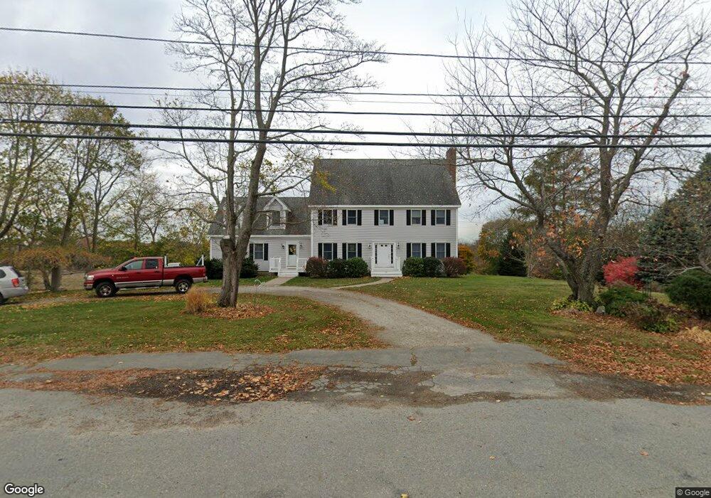
90 High Rd Newbury, MA 01951
Estimated Value: $1,288,000 - $1,590,000
4
Beds
3
Baths
3,820
Sq Ft
$370/Sq Ft
Est. Value
About This Home
This home is located at 90 High Rd, Newbury, MA 01951 and is currently estimated at $1,414,366, approximately $370 per square foot. 90 High Rd is a home located in Essex County with nearby schools including Triton Regional High School, River Valley Charter School, and Immaculate Conception School.
Ownership History
Date
Name
Owned For
Owner Type
Purchase Details
Closed on
May 22, 2024
Sold by
Stokes Brendan D and Stokes Hannah-Martha
Bought by
Stokes Ft and Stokes
Current Estimated Value
Purchase Details
Closed on
Oct 8, 1998
Sold by
Maguire Alicia H and Knight Richard F
Bought by
Stokes Brendan D and Stokes Hannah Martha
Purchase Details
Closed on
May 29, 1998
Sold by
Maguire Alicia H and Knight Richard F
Bought by
M&J Rt and Wojcicki Mark E
Create a Home Valuation Report for This Property
The Home Valuation Report is an in-depth analysis detailing your home's value as well as a comparison with similar homes in the area
Home Values in the Area
Average Home Value in this Area
Purchase History
| Date | Buyer | Sale Price | Title Company |
|---|---|---|---|
| Stokes Ft | -- | None Available | |
| Stokes Ft | -- | None Available | |
| Stokes Ft | -- | None Available | |
| Stokes Ft | -- | None Available | |
| Stokes Brendan D | $125,000 | -- | |
| M&J Rt | $160,000 | -- | |
| Stokes Brendan D | $125,000 | -- | |
| Wojcicki | $160,000 | -- |
Source: Public Records
Mortgage History
| Date | Status | Borrower | Loan Amount |
|---|---|---|---|
| Previous Owner | Wojcicki | $125,000 | |
| Previous Owner | Wojcicki | $50,000 | |
| Previous Owner | Wojcicki | $260,000 |
Source: Public Records
Tax History Compared to Growth
Tax History
| Year | Tax Paid | Tax Assessment Tax Assessment Total Assessment is a certain percentage of the fair market value that is determined by local assessors to be the total taxable value of land and additions on the property. | Land | Improvement |
|---|---|---|---|---|
| 2025 | $8,483 | $1,138,700 | $450,600 | $688,100 |
| 2024 | $8,221 | $1,070,500 | $407,700 | $662,800 |
| 2023 | $8,411 | $970,100 | $364,800 | $605,300 |
| 2022 | $8,274 | $850,400 | $321,900 | $528,500 |
| 2021 | $8,251 | $774,000 | $279,000 | $495,000 |
| 2020 | $8,194 | $745,600 | $270,400 | $475,200 |
| 2019 | $8,060 | $745,600 | $270,400 | $475,200 |
| 2018 | $7,780 | $713,800 | $270,400 | $443,400 |
| 2017 | $7,269 | $685,100 | $257,500 | $427,600 |
| 2016 | $7,278 | $638,400 | $225,300 | $413,100 |
| 2015 | $7,157 | $621,300 | $208,200 | $413,100 |
| 2014 | $7,033 | $621,300 | $208,200 | $413,100 |
Source: Public Records
Map
Nearby Homes
- 100 High Rd
- 105 High Rd Unit Lot 2
- 1 Littles Ln
- 144 High Rd
- 4 Hanover St
- 1 Lancaster Rd
- 7 Pine Island Rd
- 182 High Rd
- 26 Beacon Ave
- 33 Union St
- 4 Goodwin Ave
- 17 Madison St
- 113 Prospect St Unit B
- 24 Seaview Ln
- 222 High Rd
- 164 Water St Unit A
- 166 Water St Unit B
- 57 Lime St Unit 1
- 65 Plum Island Turnpike
- 58 Lime St Unit 5