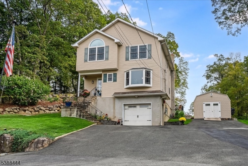
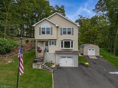
90 Salmon Rd Landing, NJ 07850
Estimated payment $4,559/month
Highlights
- Media Room
- Spa
- Colonial Architecture
- Roxbury High School Rated A-
- Lake View
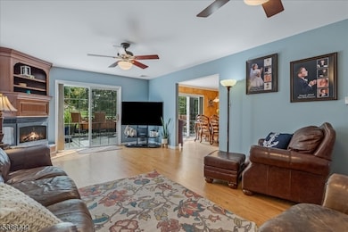
- Family Room with Fireplace
About This Home
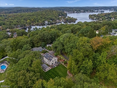
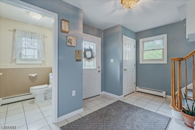
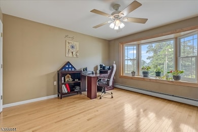
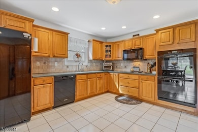
Stunning Lake Hopatcong Views! 90 Salmon Rd. Perched high on the mountain with sweeping views of Lake Hopatcong, this spacious 4+ bedroom home offers the perfect balance of everyday convenience and vacation-style living. Step inside to an open floor plan designed for gatherings, featuring a large upgraded kitchen with double oven, ample cabinetry, and pantry. The dining area opens to a Trex deck with hot tub, while the great room is anchored by a custom floor-to-ceiling gas fireplace with marble accents. A versatile bonus room on the main floor is ideal for a home office or fifth bedroom. Upstairs, the primary suite is a true retreat with vaulted ceilings, skylights, two walk-in closets, and a spa-style bath with Jacuzzi tub. Three additional bedrooms and a full bath complete the second level. The fully insulated attic provides excellent storage.The lodge-inspired finished basement adds even more living space with a wood-burning stove framed by stacked stone, custom cabinetry, Murphy bed, oversized closets, and a bonus room already plumbed and wired for a future bath or wet bar. Additional highlights include:Energy-efficient solar panels & natural gas, heated one-car garage + 24x14 shed, driveway parking for up to 8 vehicles, smart lighting & split AC, convenient location just minutes from train stations, highways, and lakefront dining. 90 Salmon Rd. is more than a home; it's a warm, welcoming retreat where you can live, relax, and entertain.
Listing Agent
SHANA DEANDREA
HAVEN REALTY Brokerage Phone: 973-566-3556 Listed on: 10/03/2025
Home Details
Home Type
- Single Family
Est. Annual Taxes
- $10,495
Year Built
- Built in 2000
Lot Details
- 7,841 Sq Ft Lot
- Cul-De-Sac
- Level Lot
Parking
- 1 Car Attached Garage
Home Design
- Colonial Architecture
- Vinyl Siding
- Tile
Interior Spaces
- 2,805 Sq Ft Home
- Wet Bar
- Cathedral Ceiling
- Skylights
- Wood Burning Fireplace
- Gas Fireplace
- Thermal Windows
- Window Treatments
- Family Room with Fireplace
- 2 Fireplaces
- Family Room with entrance to outdoor space
- Living Room
- Formal Dining Room
- Media Room
- Home Office
- Recreation Room with Fireplace
- Game Room
- Storage Room
- Laundry Room
- Lake Views
Kitchen
- Eat-In Kitchen
- Butlers Pantry
- Double Self-Cleaning Oven
- Dishwasher
Flooring
- Wood
- Wall to Wall Carpet
Bedrooms and Bathrooms
- 4 Bedrooms
- Primary bedroom located on second floor
- En-Suite Primary Bedroom
- Walk-In Closet
- Soaking Tub
Finished Basement
- Walk-Out Basement
- Basement Fills Entire Space Under The House
- Garage Access
Home Security
- Carbon Monoxide Detectors
- Fire and Smoke Detector
Outdoor Features
- Spa
- Patio
- Storage Shed
Utilities
- Central Air
- Standard Electricity
Community Details
- Powered Boats Allowed
Listing and Financial Details
- Assessor Parcel Number 2336-11106-0000-00001-0000-
Map
Home Values in the Area
Average Home Value in this Area
Tax History
| Year | Tax Paid | Tax Assessment Tax Assessment Total Assessment is a certain percentage of the fair market value that is determined by local assessors to be the total taxable value of land and additions on the property. | Land | Improvement |
|---|---|---|---|---|
| 2025 | $10,496 | $403,000 | $81,100 | $321,900 |
| 2024 | $10,332 | $381,800 | $81,100 | $300,700 |
| 2023 | $10,332 | $381,800 | $81,100 | $300,700 |
| 2022 | $10,057 | $381,800 | $81,100 | $300,700 |
| 2021 | $10,057 | $381,800 | $81,100 | $300,700 |
| 2020 | $10,038 | $381,800 | $81,100 | $300,700 |
| 2019 | $9,850 | $381,800 | $81,100 | $300,700 |
| 2018 | $10,038 | $232,900 | $37,400 | $195,500 |
| 2017 | $9,984 | $232,900 | $37,400 | $195,500 |
| 2016 | $9,789 | $232,900 | $37,400 | $195,500 |
| 2015 | $9,547 | $232,900 | $37,400 | $195,500 |
| 2014 | $9,395 | $232,900 | $37,400 | $195,500 |
Property History
| Date | Event | Price | List to Sale | Price per Sq Ft |
|---|---|---|---|---|
| 10/24/2025 10/24/25 | Price Changed | $699,000 | -9.1% | $249 / Sq Ft |
| 10/10/2025 10/10/25 | Price Changed | $769,000 | -3.8% | $274 / Sq Ft |
| 10/03/2025 10/03/25 | For Sale | $799,000 | -- | $285 / Sq Ft |
Purchase History
| Date | Type | Sale Price | Title Company |
|---|---|---|---|
| Quit Claim Deed | -- | None Listed On Document | |
| Quit Claim Deed | -- | None Listed On Document | |
| Quit Claim Deed | -- | None Listed On Document | |
| Deed | $357,000 | -- | |
| Deed | $249,900 | Chicago Title Insurance Co |
Mortgage History
| Date | Status | Loan Amount | Loan Type |
|---|---|---|---|
| Previous Owner | $300,700 | No Value Available | |
| Previous Owner | $199,920 | No Value Available |
Source: Garden State MLS
MLS Number: 3990566
APN: 36-11106-0000-00001
Disclaimer: Certain information contained herein is derived from information provided by parties other than Homes.com. All information provided is deemed reliable, but is not guaranteed to be accurate and should be independently verified.
![]() The data relating to real estate for sale on this website comes in part from the IDX Program of Garden State Multiple Listing Service, L.L.C. Real estate listings held by other brokerage firms are marked as IDX Listing.
The data relating to real estate for sale on this website comes in part from the IDX Program of Garden State Multiple Listing Service, L.L.C. Real estate listings held by other brokerage firms are marked as IDX Listing.
Information deemed reliable but not guaranteed.
Copyright © 2025 Garden State Multiple Listing Service, L.L.C. All rights reserved.
Notice: The dissemination of listings on this website does not constitute the consent required by N.J.A.C. 11:5.6.1 (n) for the advertisement of listings exclusively for sale by another broker. Any such consent must be obtained in writing from the listing broker.
This information is being provided for Consumers’ personal, non-commercial use and may not be used for any purpose other than to identify prospective properties Consumers may be interested in purchasing.
- 33 Ford Rd Unit 35
- 5 Zachary Dr
- Oakmont Grand Plan at Stone Water Village
- Roanoke Plan at Stone Water Village
- Normandy Plan at Stone Water Village
- 11 Bell Ct
- 2 Zachary Dr
- 13 Mansel Dr
- 504 Ryerson Rd
- 181 Orben Dr
- 512 Colver Rd
- 514 Colver Rd
- 37 Esposito Ln
- 545 Rogers Dr
- 502 Mansel Dr
- 168 Ledge-Landing
- 505 Logan Dr
- 540 Vail Rd
- 100 Zachary Way Unit 100
- 137 Lakeside Blvd
- 142 Mount Arlington Blvd
- 90 Ford Rd
- 21 Woodland Way
- 100 Fieldstone Dr
- 48 Woodland Way
- 45 Crestview Ln
- 1 Hillside Dr
- 205 Mariners Pointe
- 7 King Rd
- 31 Lakeside Blvd Unit A
- 500-504 Bensel Dr
- 297 Center St Unit A
- 566 Main St Land Unit 2
- 48 Henry Ct
- 74 Bertrand Island Rd Unit 54
- 100 N Bertrand Rd
- 107 N Bertrand Rd
- 163 Route 46 W
- 2 Marc Ct
- 495 Windemere Ave Unit A