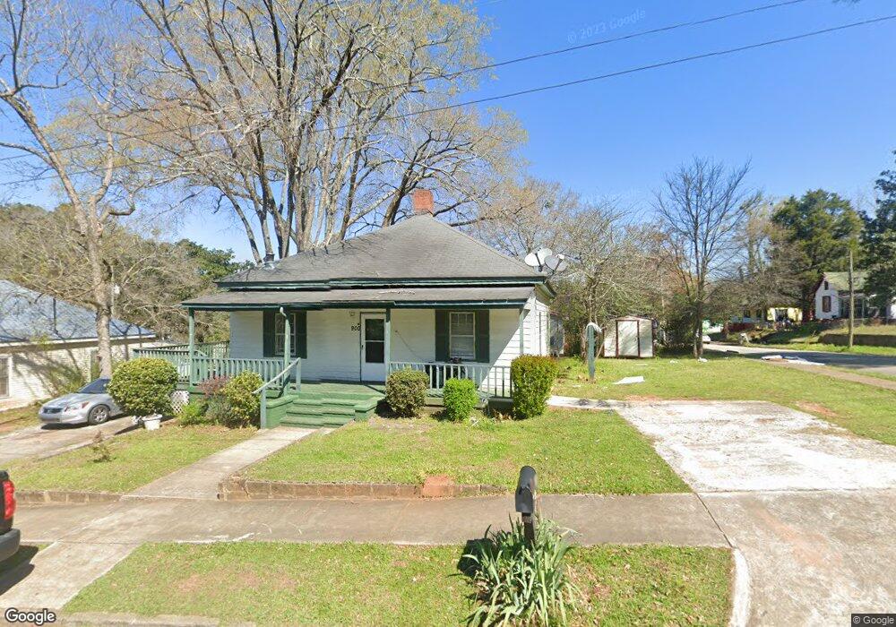
900 4th Ave Lagrange, GA 30240
Estimated Value: $122,000 - $170,000
3
Beds
3
Baths
1,854
Sq Ft
$81/Sq Ft
Est. Value
About This Home
This home is located at 900 4th Ave, Lagrange, GA 30240 and is currently estimated at $150,406, approximately $81 per square foot. 900 4th Ave is a home located in Troup County with nearby schools including Berta Weathersbee Elementary School, Whitesville Road Elementary School, and Rosemont Elementary School.
Ownership History
Date
Name
Owned For
Owner Type
Purchase Details
Closed on
Mar 26, 2015
Sold by
Federal National Mortgage Association
Bought by
Taylor Phillip A
Current Estimated Value
Home Financials for this Owner
Home Financials are based on the most recent Mortgage that was taken out on this home.
Original Mortgage
$25,000
Interest Rate
3.89%
Mortgage Type
New Conventional
Purchase Details
Closed on
Oct 2, 2014
Sold by
Sun West Mtg Co Inc
Bought by
Federal National Mtg Associati
Purchase Details
Closed on
Jul 5, 1994
Sold by
White Michael
Bought by
Truitt Jafus
Purchase Details
Closed on
May 9, 1994
Sold by
Philip Anthony Taylor
Bought by
White Michael
Purchase Details
Closed on
Mar 1, 1987
Sold by
Mrs Pauline P Taylor
Bought by
Philip Anthony Taylor
Purchase Details
Closed on
Jan 1, 1961
Sold by
Grady L Taylor
Bought by
Mrs Pauline P Taylor
Create a Home Valuation Report for This Property
The Home Valuation Report is an in-depth analysis detailing your home's value as well as a comparison with similar homes in the area
Purchase History
| Date | Buyer | Sale Price | Title Company |
|---|---|---|---|
| Taylor Phillip A | -- | -- | |
| Federal National Mtg Associati | -- | -- | |
| Sun West Mtg Co Inc | -- | -- | |
| Truitt Jafus | $52,000 | -- | |
| White Michael | $11,500 | -- | |
| Philip Anthony Taylor | -- | -- | |
| Mrs Pauline P Taylor | -- | -- |
Source: Public Records
Mortgage History
| Date | Status | Borrower | Loan Amount |
|---|---|---|---|
| Closed | Taylor Phillip A | $25,000 |
Source: Public Records
Tax History
| Year | Tax Paid | Tax Assessment Tax Assessment Total Assessment is a certain percentage of the fair market value that is determined by local assessors to be the total taxable value of land and additions on the property. | Land | Improvement |
|---|---|---|---|---|
| 2025 | $944 | $34,612 | $2,520 | $32,092 |
| 2024 | $867 | $31,776 | $2,520 | $29,256 |
| 2023 | $681 | $24,980 | $2,520 | $22,460 |
| 2022 | $655 | $23,460 | $2,520 | $20,940 |
| 2021 | $478 | $15,848 | $2,520 | $13,328 |
| 2020 | $478 | $15,848 | $2,520 | $13,328 |
| 2019 | $439 | $14,572 | $2,520 | $12,052 |
| 2018 | $430 | $14,252 | $2,520 | $11,732 |
| 2017 | $430 | $14,252 | $2,520 | $11,732 |
| 2016 | $407 | $13,480 | $5,445 | $8,035 |
| 2015 | $525 | $12,842 | $2,531 | $10,310 |
| 2014 | $675 | $24,298 | $2,588 | $21,710 |
| 2013 | -- | $25,577 | $2,588 | $22,989 |
Source: Public Records
Map
Nearby Homes
- 900 B N Pkwy
- 1205 Park Ave
- 1308 Park Ave
- 1311 Juniper St
- 1304 Forrest Ave
- 1405 Forrest Ave
- 1402 Forrest Ave
- 1300 Murphy Ave
- 1308 Forrest Ave
- 1808 Murphy Ave
- 606 Poplar St
- 1004 Callaway Ave
- 799 Hunnicutt St
- 797 Hunnicutt St
- 812 Elm St
- 1015 Stonewall St
- 1017 Stonewall St
- 914 Todd St
- 1186 Lindsey St
- 613 S Lee St
Your Personal Tour Guide
Ask me questions while you tour the home.