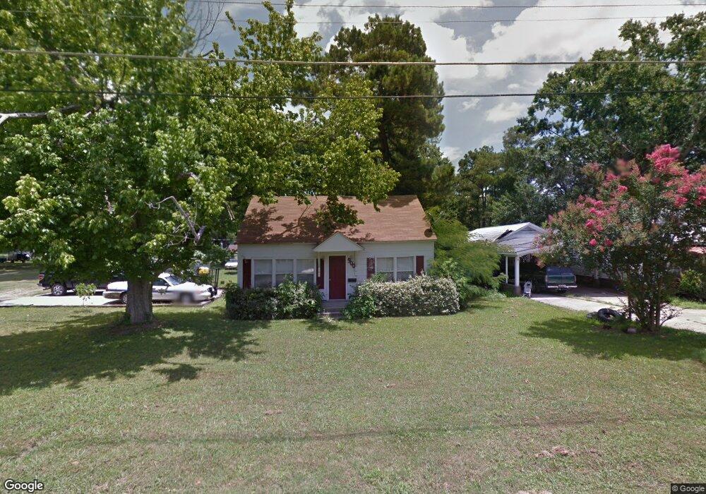
900 Carroll St Tallulah, LA 71282
Estimated Value: $23,000 - $229,000
--
Bed
--
Bath
--
Sq Ft
6,273
Sq Ft Lot
About This Home
This home is located at 900 Carroll St, Tallulah, LA 71282 and is currently estimated at $89,901. 900 Carroll St is a home with nearby schools including Tallulah Charter School and Tallulah Academy - Delta Christian School.
Ownership History
Date
Name
Owned For
Owner Type
Purchase Details
Closed on
Dec 27, 2023
Sold by
James A Fedrick And Son Properties Llc
Bought by
Banks Dysheka
Current Estimated Value
Purchase Details
Closed on
Jun 29, 2017
Sold by
Machen Cecil Alan
Bought by
James A Federick And Son Properties Llc
Purchase Details
Closed on
May 25, 2016
Sold by
Higgins Albert M
Bought by
James A Federick And Son Properties Llc
Purchase Details
Closed on
Jan 30, 2012
Sold by
Machen Cecil Paul and Machen Debra G
Bought by
Machen Cecil Alan
Create a Home Valuation Report for This Property
The Home Valuation Report is an in-depth analysis detailing your home's value as well as a comparison with similar homes in the area
Home Values in the Area
Average Home Value in this Area
Purchase History
| Date | Buyer | Sale Price | Title Company |
|---|---|---|---|
| Banks Dysheka | $1,000 | None Listed On Document | |
| James A Federick And Son Properties Llc | $14,000 | None Available | |
| James A Federick And Son Properties Llc | $4,000 | -- | |
| Machen Cecil Alan | -- | -- |
Source: Public Records
Tax History Compared to Growth
Tax History
| Year | Tax Paid | Tax Assessment Tax Assessment Total Assessment is a certain percentage of the fair market value that is determined by local assessors to be the total taxable value of land and additions on the property. | Land | Improvement |
|---|---|---|---|---|
| 2024 | $355 | $2,600 | $300 | $2,300 |
| 2023 | $282 | $2,600 | $300 | $2,300 |
| 2022 | $360 | $2,600 | $300 | $2,300 |
| 2021 | $360 | $2,600 | $300 | $2,300 |
| 2020 | $360 | $2,600 | $300 | $2,300 |
| 2019 | $359 | $2,600 | $300 | $2,300 |
| 2018 | $361 | $2,600 | $300 | $2,300 |
| 2017 | $361 | $2,600 | $300 | $2,300 |
| 2016 | $361 | $2,600 | $300 | $2,300 |
| 2015 | $380 | $2,698 | $171 | $2,527 |
| 2014 | $375 | $2,698 | $171 | $2,527 |
Source: Public Records
Map
Nearby Homes
- 1104 Maple St
- 1200 Louisiana St
- 1204 Louisiana St
- 1222 Mississippi St
- 000 Highway 65
- 0 Felicia Dr Unit 14.22 acres 214011
- 0 Felicia Dr Unit 9.833 acres 214010
- 0 Felicia Dr Unit 24.05 acres
- 402 S Lincoln St
- 00 Highway 65 Unit 10.88 acres
- 0 Highway 65 Unit 5.054 acres
- 300 S Lincoln St
- 1504 Mississippi St
- 111 Burnside Dr
- 114 Burnside Dr
- 208 Sheri Kay St
- 408 N Lincoln St
- 105 Belle Ln
- 820 van Zelfden St
- 1007 Bear Lake Rd E
- 812 Carroll St
- 904 Carroll St
- 901 Madison St
- 905 Madison St
- 810 Carroll St
- 809 Madison St
- 809 Carroll St
- 1103 De Soto St
- 907 Madison St
- 909 Madison St
- 1116 La Salle St
- 910 Carroll St
- 911 Carroll St
- 1114 La Salle St
- 1204 La Salle St
- 807 Madison St
- 911 Madison St
- 911 Madison St
- 815 Carroll St
- 902 Madison St