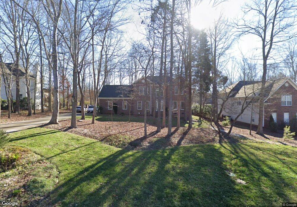
900 Houston Dr Monroe, NC 28110
Estimated Value: $553,423 - $568,000
4
Beds
3
Baths
2,867
Sq Ft
$195/Sq Ft
Est. Value
About This Home
This home is located at 900 Houston Dr, Monroe, NC 28110 and is currently estimated at $559,106, approximately $195 per square foot. 900 Houston Dr is a home located in Union County with nearby schools including Shiloh Valley Primary School, Shiloh Valley Elementary School, and Sun Valley Middle School.
Ownership History
Date
Name
Owned For
Owner Type
Purchase Details
Closed on
May 17, 2019
Sold by
Blichmann Robert B and Bond Betsy J
Bought by
Nelson Grant Phillip and Nelson Deanne Rene
Current Estimated Value
Home Financials for this Owner
Home Financials are based on the most recent Mortgage that was taken out on this home.
Original Mortgage
$241,500
Outstanding Balance
$211,009
Interest Rate
4.1%
Mortgage Type
New Conventional
Estimated Equity
$348,097
Create a Home Valuation Report for This Property
The Home Valuation Report is an in-depth analysis detailing your home's value as well as a comparison with similar homes in the area
Purchase History
| Date | Buyer | Sale Price | Title Company |
|---|---|---|---|
| Nelson Grant Phillip | $341,500 | None Available |
Source: Public Records
Mortgage History
| Date | Status | Borrower | Loan Amount |
|---|---|---|---|
| Open | Nelson Grant Phillip | $241,500 |
Source: Public Records
Tax History
| Year | Tax Paid | Tax Assessment Tax Assessment Total Assessment is a certain percentage of the fair market value that is determined by local assessors to be the total taxable value of land and additions on the property. | Land | Improvement |
|---|---|---|---|---|
| 2025 | $2,524 | $518,200 | $0 | $0 |
| 2024 | $2,089 | $324,300 | $65,100 | $259,200 |
| 2023 | $2,070 | $324,300 | $65,100 | $259,200 |
| 2022 | $2,070 | $324,300 | $65,100 | $259,200 |
| 2021 | $2,066 | $324,300 | $65,100 | $259,200 |
| 2020 | $1,868 | $237,500 | $44,000 | $193,500 |
| 2019 | $1,859 | $237,500 | $44,000 | $193,500 |
| 2018 | $1,859 | $237,500 | $44,000 | $193,500 |
| 2017 | $1,964 | $237,500 | $44,000 | $193,500 |
| 2016 | $1,929 | $237,500 | $44,000 | $193,500 |
| 2015 | $1,950 | $237,500 | $44,000 | $193,500 |
| 2014 | $1,986 | $282,370 | $55,000 | $227,370 |
Source: Public Records
Map
Nearby Homes
- 5314 Woodridge Dr
- 5407 Berrywood Ln
- 1005 Theodore Ln
- 3043 Streamlet Way
- 1020 Laparc Ln
- 1006 Heritage Pointe
- 1003 Cabra Ct
- 4003 Salmon River Dr
- 2006 Great Falls Dr
- 6004 Brook Valley Run
- 5106 Twin Cedars Dr
- 1302 Langdon Terrace Dr
- 2009 Orby Ave
- 1006 Apogee Dr
- 1308 Vintage Walk Dr
- 316 Wade Hampton Dr
- 2118 Old Evergreen Pkwy
- 5412 Fulton Ridge Dr
- 4004 Magna Ln
- 5607 Fulton Ridge Dr
- 900 Houston Dr Unit 77
- 902 Houston Dr
- 808 Houston Dr
- 904 Houston Dr
- 806 Houston Dr Unit 79
- 806 Houston Dr
- 900 Woodhurst Dr
- 811 Pilgrim Forest Dr
- 901 Houston Dr
- 906 Houston Dr
- 805 Pilgrim Forest Dr
- 804 Houston Dr
- 815 Pilgrim Forest Dr
- 902 Woodhurst Dr
- 903 Woodhurst Dr
- 908 Houston Dr
- 802 Houston Dr
- 901 Pilgrim Forest Dr
- 904 Woodhurst Dr
- 5300 Woodridge Dr
Your Personal Tour Guide
Ask me questions while you tour the home.