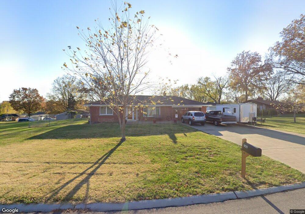
900 Lynton Dr Saint Louis, MO 63129
Mehlville NeighborhoodEstimated Value: $243,541 - $257,000
2
Beds
2
Baths
1,062
Sq Ft
$235/Sq Ft
Est. Value
About This Home
This home is located at 900 Lynton Dr, Saint Louis, MO 63129 and is currently estimated at $249,135, approximately $234 per square foot. 900 Lynton Dr is a home located in St. Louis County with nearby schools including Blades Elementary School, Bernard Middle School, and Oakville Senior High School.
Ownership History
Date
Name
Owned For
Owner Type
Purchase Details
Closed on
Jun 6, 2011
Sold by
Matzker James Edward
Bought by
Moore Kenneth J
Current Estimated Value
Purchase Details
Closed on
May 26, 2011
Sold by
Matzker Dolores J
Bought by
James Edward Matzker Revocable Trust
Purchase Details
Closed on
Mar 12, 2006
Sold by
Matzker James Edward and Matzker Edward James
Bought by
Matzker Edward and James Edward Matzker Revocable Trust
Create a Home Valuation Report for This Property
The Home Valuation Report is an in-depth analysis detailing your home's value as well as a comparison with similar homes in the area
Home Values in the Area
Average Home Value in this Area
Purchase History
| Date | Buyer | Sale Price | Title Company |
|---|---|---|---|
| Moore Kenneth J | $75,000 | Assured Title Company | |
| James Edward Matzker Revocable Trust | -- | None Available | |
| Matzker Edward | -- | None Available |
Source: Public Records
Tax History Compared to Growth
Tax History
| Year | Tax Paid | Tax Assessment Tax Assessment Total Assessment is a certain percentage of the fair market value that is determined by local assessors to be the total taxable value of land and additions on the property. | Land | Improvement |
|---|---|---|---|---|
| 2025 | $2,474 | $46,810 | $29,390 | $17,420 |
| 2024 | $2,474 | $36,680 | $13,400 | $23,280 |
| 2023 | $2,442 | $36,680 | $13,400 | $23,280 |
| 2022 | $2,124 | $32,020 | $13,400 | $18,620 |
| 2021 | $2,056 | $32,020 | $13,400 | $18,620 |
| 2020 | $1,993 | $29,510 | $12,160 | $17,350 |
| 2019 | $1,987 | $29,510 | $12,160 | $17,350 |
| 2018 | $1,822 | $24,400 | $10,070 | $14,330 |
| 2017 | $1,819 | $24,400 | $10,070 | $14,330 |
| 2016 | $1,966 | $25,330 | $10,070 | $15,260 |
| 2015 | $1,806 | $25,330 | $10,070 | $15,260 |
| 2014 | $1,603 | $22,220 | $5,420 | $16,800 |
Source: Public Records
Map
Nearby Homes
- 35 Berview Cir Unit E
- 1 Berview Cir Unit B
- 9 Berview Cir Unit H
- 4248 Kingbolt Blvd Unit D
- 929 Peace Haven Dr
- 4101 Forder Circle Dr
- 1141 Sunbolt Dr Unit C
- 4061 Morningview Ct
- 1057 Mersey Bend Dr Unit C
- 851 Poplar Dr
- 4376 Tavistock Cir Unit 18D
- 4363 Tavistock Cir Unit 22C
- 4298 Chateau de Ville Dr Unit A
- 1084 Mersey Bend Dr Unit F
- 4347 Chateau de Ville Dr Unit G
- 1076 Humber Cir
- 4343 Chateau de Ville Dr
- 4353 Chateau de Ville Dr Unit D
- 4374 Forest de Ville Dr Unit 32A
- 4300 Forder Gardens Place Unit G
- 910 Lynton Dr
- 4025 Linmore Dr
- 901 Lynton Dr
- 909 Linford Dr
- 4000 Linmore Dr
- 4014 Linmore Dr
- 4024 Linmore Dr
- 917 Linford Dr
- 920 Lynton Dr
- 915 Lynton Dr
- 4030 Linmore Dr
- 4036 Linmore Dr
- 925 Linford Dr
- 928 Lynton Dr
- 4101 Rinzetta Dr
- 925 Lynton Dr
- 4109 Rinzetta Dr
- 4043 Linmore Dr
- 842 Kinswood Ln
- 4117 Rinzetta Dr