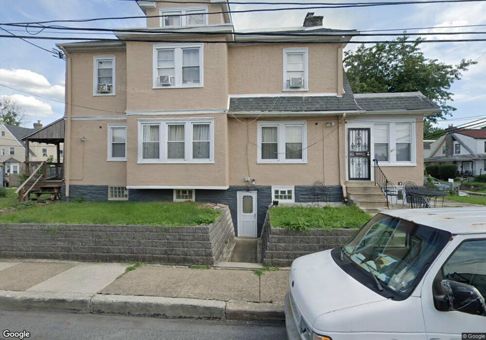
901 Bullock Ave Lansdowne, PA 19050
Estimated Value: $234,000 - $270,000
3
Beds
1
Bath
1,504
Sq Ft
$166/Sq Ft
Est. Value
About This Home
This home is located at 901 Bullock Ave, Lansdowne, PA 19050 and is currently estimated at $249,150, approximately $165 per square foot. 901 Bullock Ave is a home located in Delaware County with nearby schools including Evans Elementary School, Penn Wood Middle School, and Penn Wood High School - Cypress Street Campus.
Ownership History
Date
Name
Owned For
Owner Type
Purchase Details
Closed on
Sep 28, 2001
Sold by
Ghebrat Isaac and Ghebrat Hansu G
Bought by
Kakay Abdulah and Tarawallie Aminata
Current Estimated Value
Home Financials for this Owner
Home Financials are based on the most recent Mortgage that was taken out on this home.
Original Mortgage
$84,233
Outstanding Balance
$32,972
Interest Rate
6.89%
Mortgage Type
FHA
Estimated Equity
$216,178
Create a Home Valuation Report for This Property
The Home Valuation Report is an in-depth analysis detailing your home's value as well as a comparison with similar homes in the area
Home Values in the Area
Average Home Value in this Area
Purchase History
| Date | Buyer | Sale Price | Title Company |
|---|---|---|---|
| Kakay Abdulah | $84,900 | Commonwealth Land Title Ins |
Source: Public Records
Mortgage History
| Date | Status | Borrower | Loan Amount |
|---|---|---|---|
| Open | Kakay Abdulah | $84,233 |
Source: Public Records
Tax History Compared to Growth
Tax History
| Year | Tax Paid | Tax Assessment Tax Assessment Total Assessment is a certain percentage of the fair market value that is determined by local assessors to be the total taxable value of land and additions on the property. | Land | Improvement |
|---|---|---|---|---|
| 2025 | $4,953 | $115,990 | $32,240 | $83,750 |
| 2024 | $4,953 | $115,990 | $32,240 | $83,750 |
| 2023 | $4,498 | $115,990 | $32,240 | $83,750 |
| 2022 | $4,289 | $115,990 | $32,240 | $83,750 |
| 2021 | $6,486 | $115,990 | $32,240 | $83,750 |
| 2020 | $4,261 | $68,230 | $18,600 | $49,630 |
| 2019 | $4,186 | $68,230 | $18,600 | $49,630 |
| 2018 | $4,128 | $68,230 | $0 | $0 |
| 2017 | $4,041 | $68,230 | $0 | $0 |
| 2016 | $374 | $68,230 | $0 | $0 |
| 2015 | $374 | $68,230 | $0 | $0 |
| 2014 | $374 | $68,230 | $0 | $0 |
Source: Public Records
Map
Nearby Homes
- 908 Yeadon Ave
- 921 Serrill Ave
- 939 Serrill Ave
- 808 Serrill Ave
- 825 Laurel Rd
- 800 Bullock Ave
- 923 Bell Ave
- 813 Arbor Rd
- 740 Church Ln
- 722 Yeadon Ave
- 711 Yeadon Ave Unit 1
- 1049 Yeadon Ave
- 702 Cedar Ave
- 6718 Cobbs Creek Pkwy
- 6535 Windsor St
- 1016 Whitby Ave
- 1781 S 65th St
- 6835 Chester Ave
- 6951 Chester Ave
- 6564 Belmar St
- 903 Bullock Ave
- 905 Bullock Ave
- 851 Bullock Ave
- 907 Bullock Ave
- 849 Bullock Ave
- 909 Bullock Ave
- 900 Church Ln
- 847 Bullock Ave
- 850 Church Ln
- 900-902 Church Ln
- 911 Bullock Ave
- 848 Church Ln
- 906 Church Ln
- 845 Bullock Ave
- 913 Bullock Ave
- 900 Bullock Ave
- 846 Church Ln
- 902 Bullock Ave
- 904 Bullock Ave
- 843 Bullock Ave