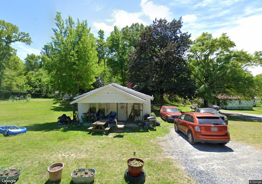
901 Hillsdale Rd La Fayette, GA 30728
Estimated Value: $103,654 - $173,000
--
Bed
1
Bath
1,032
Sq Ft
$147/Sq Ft
Est. Value
About This Home
This home is located at 901 Hillsdale Rd, La Fayette, GA 30728 and is currently estimated at $151,414, approximately $146 per square foot. 901 Hillsdale Rd is a home located in Walker County with nearby schools including Gilbert Elementary School, Lafayette Middle School, and Lafayette High School.
Ownership History
Date
Name
Owned For
Owner Type
Purchase Details
Closed on
Mar 18, 2020
Sold by
White Leon Arnold
Bought by
Painter Thomas J
Current Estimated Value
Purchase Details
Closed on
Mar 15, 2002
Sold by
White Leon Arnold
Bought by
White Leon Arnold and White Maxine
Purchase Details
Closed on
Dec 12, 1978
Sold by
Stanfield Eunetta
Bought by
Stanfield John F and Stanfield Eunetta
Purchase Details
Closed on
Jan 19, 1978
Sold by
Harris Roy Mrs
Bought by
Stanfield Eunetta
Purchase Details
Closed on
Jan 1, 1972
Bought by
Harris Roy Mrs
Create a Home Valuation Report for This Property
The Home Valuation Report is an in-depth analysis detailing your home's value as well as a comparison with similar homes in the area
Home Values in the Area
Average Home Value in this Area
Purchase History
| Date | Buyer | Sale Price | Title Company |
|---|---|---|---|
| Painter Thomas J | $25,000 | -- | |
| White Leon Arnold | -- | -- | |
| Stanfield John F | -- | -- | |
| Stanfield Eunetta | -- | -- | |
| Harris Roy Mrs | -- | -- |
Source: Public Records
Tax History Compared to Growth
Tax History
| Year | Tax Paid | Tax Assessment Tax Assessment Total Assessment is a certain percentage of the fair market value that is determined by local assessors to be the total taxable value of land and additions on the property. | Land | Improvement |
|---|---|---|---|---|
| 2024 | $744 | $31,232 | $4,402 | $26,830 |
| 2023 | $732 | $29,804 | $4,402 | $25,402 |
| 2022 | $683 | $25,928 | $4,402 | $21,526 |
| 2021 | $294 | $15,832 | $4,402 | $11,430 |
| 2020 | $435 | $14,173 | $4,402 | $9,771 |
| 2019 | $435 | $14,173 | $4,402 | $9,771 |
| 2018 | $422 | $14,173 | $4,402 | $9,771 |
| 2017 | $472 | $14,173 | $4,402 | $9,771 |
| 2016 | $391 | $14,173 | $4,402 | $9,771 |
| 2015 | $476 | $16,433 | $5,616 | $10,817 |
| 2014 | $458 | $16,433 | $5,616 | $10,817 |
| 2013 | -- | $16,432 | $5,616 | $10,816 |
Source: Public Records
Map
Nearby Homes
- 0 N Chattanooga St
- 1 & 3 N High St
- 212 S High St
- 0 Fortune St Unit 1520483
- 204 S High St
- 3 Fortune St
- 702.5 Henderson St
- 13 Steele St N
- 613 Bradley Ave
- 206 Glenn St
- 205 Cavender St
- 301 Cedar St
- 307 Cavender St
- 306 Cedar St
- 312 Pine St
- 0 W Main St Unit 1518094
- 317 Cedar St
- 316 Chestnut St
- 408 Chestnut St
- 405 Magnolia St
- 901 N Chattanooga St
- 903 Hillsdale Rd
- 809 N Chattanooga St
- 905 Hillsdale Rd
- 905 N Chattanooga St
- 713 N Chattanooga St
- 39 King St
- 36 King St
- 910 Hillsdale Rd
- 710 N Chattanooga St
- 304 1/2 3rd Ave
- 35 King St
- 803 W 2nd Ave
- 3 3rd Ave
- 306 W 3rd Ave
- 306 3rd Ave
- 304 3rd Ave
- 34 King St
- N N Chattanooga St
- 302 3rd Ave