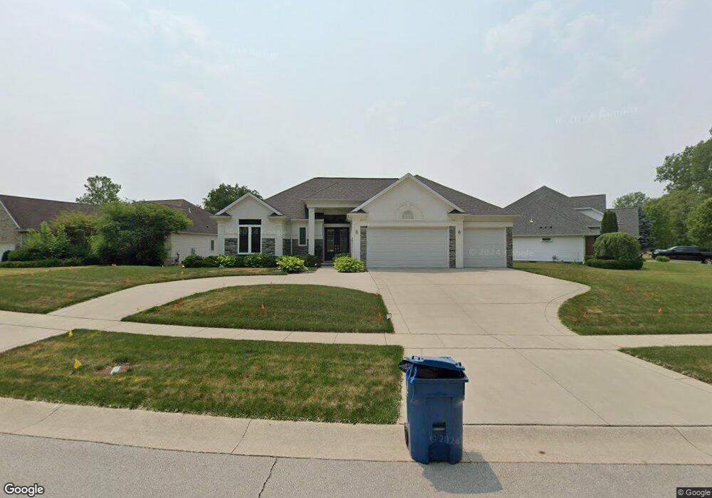
901 Tall Pines Dr Toledo, OH 43615
Estimated Value: $380,000 - $478,077
3
Beds
3
Baths
2,360
Sq Ft
$177/Sq Ft
Est. Value
About This Home
This home is located at 901 Tall Pines Dr, Toledo, OH 43615 and is currently estimated at $417,269, approximately $176 per square foot. 901 Tall Pines Dr is a home located in Lucas County with nearby schools including Dorr Street Elementary School, Springfield Middle School, and Springfield High School.
Ownership History
Date
Name
Owned For
Owner Type
Purchase Details
Closed on
Jan 21, 2020
Sold by
Bishop Brian Anthony and Bishop Brian
Bought by
Thomas Tamieca Nyree and Bishop Tamieca
Current Estimated Value
Purchase Details
Closed on
Oct 29, 2012
Sold by
Mclntyre Milton T and Mclntyre Lenora E
Bought by
Bishop Brian and Bishop Tamieca
Home Financials for this Owner
Home Financials are based on the most recent Mortgage that was taken out on this home.
Original Mortgage
$41,250
Interest Rate
3.4%
Mortgage Type
New Conventional
Purchase Details
Closed on
May 8, 2006
Sold by
M R Development Llc
Bought by
Mcintyre Milton T and Mcintyre Lenora E
Home Financials for this Owner
Home Financials are based on the most recent Mortgage that was taken out on this home.
Original Mortgage
$65,000
Interest Rate
9.12%
Mortgage Type
Fannie Mae Freddie Mac
Create a Home Valuation Report for This Property
The Home Valuation Report is an in-depth analysis detailing your home's value as well as a comparison with similar homes in the area
Home Values in the Area
Average Home Value in this Area
Purchase History
| Date | Buyer | Sale Price | Title Company |
|---|---|---|---|
| Thomas Tamieca Nyree | -- | None Available | |
| Bishop Brian | $550,000 | None Available | |
| Mcintyre Milton T | $65,000 | None Available |
Source: Public Records
Mortgage History
| Date | Status | Borrower | Loan Amount |
|---|---|---|---|
| Closed | Bishop Brian | $41,250 | |
| Previous Owner | Mcintyre Milton T | $65,000 |
Source: Public Records
Tax History Compared to Growth
Tax History
| Year | Tax Paid | Tax Assessment Tax Assessment Total Assessment is a certain percentage of the fair market value that is determined by local assessors to be the total taxable value of land and additions on the property. | Land | Improvement |
|---|---|---|---|---|
| 2024 | $4,764 | $157,150 | $13,510 | $143,640 |
| 2023 | $6,571 | $93,870 | $7,840 | $86,030 |
| 2022 | $6,557 | $93,870 | $7,840 | $86,030 |
| 2021 | $6,164 | $93,870 | $7,840 | $86,030 |
| 2020 | $8,164 | $110,985 | $7,595 | $103,390 |
| 2019 | $7,979 | $110,985 | $7,595 | $103,390 |
| 2018 | $8,191 | $110,985 | $7,595 | $103,390 |
| 2017 | $8,405 | $108,465 | $7,420 | $101,045 |
| 2016 | $8,484 | $309,900 | $21,200 | $288,700 |
| 2015 | $8,470 | $309,900 | $21,200 | $288,700 |
| 2014 | $514 | $7,140 | $7,140 | $0 |
| 2013 | $514 | $7,140 | $7,140 | $0 |
Source: Public Records
Map
Nearby Homes
- 1053 Plum Grove Ln
- 7111 Nebraska Ave
- 1234 Plum Grove Ln
- 226 Perrine St
- 2116 Sunrise Creek Dr
- 2015 King Rd
- 2143 Fieldbrook Dr
- 2150 Fieldbrook Dr
- 7238 Lilac Ct
- 2110 Austin Bluffs Ct
- 2133 Saint Andrews Bluff Unit 2133
- 134 Deerfield Dr
- 7709 Fountain Dr
- 2154 The Bluffs Unit 2154
- 127 N Dorcas Rd
- 617 & 621 S Mccord Rd
- 2266 Saint James Woods Blvd
- 2321 Saint James Woods Blvd
- 217 Pebble Beach Dr
- 7944 Hill Ave
- 825 Tall Pines Dr
- 913 Tall Pines Dr
- 923 Tall Pines Dr
- 817 Tall Pines Dr
- 933 Tall Pines Dr
- 7318 Balsum Ct
- 809 Tall Pines Dr
- 7326 Balsum Ct
- 943 Tall Pines Dr
- 7332 Balsum Ct
- 942 High Pines Dr
- 7331 Balsum Ct
- 727 Tall Pines Dr
- 932 High Pines Dr
- 7325 Balsum Ct
- 922 High Pines Dr
- 7418 Blue Spruce Ct
- 719 Tall Pines Dr
- 1001 Morack Dr
- 7417 Blue Spruce Ct