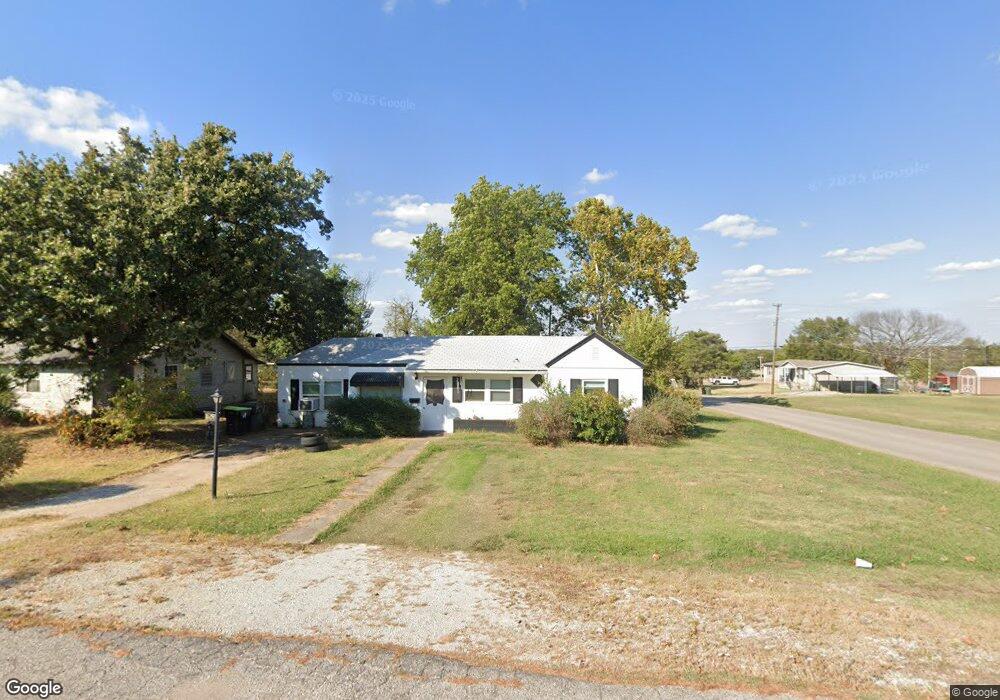
901 W Maple St Tecumseh, OK 74873
Estimated Value: $78,000 - $111,000
3
Beds
1
Bath
1,422
Sq Ft
$67/Sq Ft
Est. Value
About This Home
This home is located at 901 W Maple St, Tecumseh, OK 74873 and is currently estimated at $95,902, approximately $67 per square foot. 901 W Maple St is a home located in Pottawatomie County with nearby schools including Cross Timbers Elementary School, Barnard Elementary School, and Tecumseh Middle School.
Ownership History
Date
Name
Owned For
Owner Type
Purchase Details
Closed on
Dec 20, 2022
Sold by
Melot Judith Gail
Bought by
Onpointe Equity Llc
Current Estimated Value
Purchase Details
Closed on
May 12, 2022
Sold by
Gail Melot Judith
Bought by
Melot Judith Gail and Melot Alan Pierre
Purchase Details
Closed on
May 11, 2022
Sold by
Gail Melot Judith
Bought by
Melot Judith Gail and Melot Alan Pierre
Purchase Details
Closed on
Mar 27, 2006
Sold by
Melot Alva D
Bought by
Melot Judith Gail and Melot Alan Pierre
Purchase Details
Closed on
Mar 2, 2006
Sold by
Melot Alva D
Bought by
Melot Judith Gail and Melot Alan Pierre
Create a Home Valuation Report for This Property
The Home Valuation Report is an in-depth analysis detailing your home's value as well as a comparison with similar homes in the area
Home Values in the Area
Average Home Value in this Area
Purchase History
| Date | Buyer | Sale Price | Title Company |
|---|---|---|---|
| Onpointe Equity Llc | $60,000 | First Title & Abstract | |
| Melot Judith Gail | -- | None Listed On Document | |
| Melot Judith Gail | -- | None Listed On Document | |
| Melot Judith Gail | -- | None Available | |
| Melot Judith Gail | -- | None Available |
Source: Public Records
Tax History
| Year | Tax Paid | Tax Assessment Tax Assessment Total Assessment is a certain percentage of the fair market value that is determined by local assessors to be the total taxable value of land and additions on the property. | Land | Improvement |
|---|---|---|---|---|
| 2025 | $751 | $7,560 | $630 | $6,930 |
| 2024 | $770 | $7,200 | $600 | $6,600 |
| 2023 | $770 | $7,200 | $600 | $6,600 |
| 2022 | $325 | $4,169 | $404 | $3,765 |
| 2021 | $329 | $4,169 | $404 | $3,765 |
| 2020 | $327 | $4,168 | $404 | $3,764 |
| 2019 | $330 | $4,168 | $404 | $3,764 |
| 2018 | $319 | $4,047 | $392 | $3,655 |
| 2017 | $309 | $3,929 | $382 | $3,547 |
| 2016 | $267 | $3,814 | $371 | $3,443 |
| 2015 | $249 | $3,704 | $358 | $3,346 |
| 2014 | $249 | $3,596 | $349 | $3,247 |
Source: Public Records
Map
Nearby Homes
- 314 N 13th St
- 506 N 13th St
- 721 W Main St
- 508 Cottonwood Ln
- 501 W Washington St
- 513 W Main St
- 712 W Jefferson St
- 603 S 13th St
- 209 E Main St
- 311 E Jefferson St
- 421 E Maple St
- 416 E Washington St
- 0 Highway 9
- 46191 Highway 9
- 208 E Tennyson St
- 122 Robin Ln
- 417 E Beech St
- 0 N Rangeline St
- 1101 Sandy Rock Rd
- 617 E Washington St
Your Personal Tour Guide
Ask me questions while you tour the home.