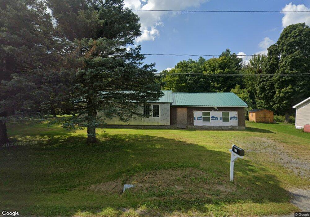
9015 State Route 22 West Chazy, NY 12992
Estimated Value: $82,000 - $183,000
2
Beds
1
Bath
1,688
Sq Ft
$72/Sq Ft
Est. Value
About This Home
This home is located at 9015 State Route 22, West Chazy, NY 12992 and is currently estimated at $122,249, approximately $72 per square foot. 9015 State Route 22 is a home located in Clinton County with nearby schools including Northeastern Clinton Senior High School.
Ownership History
Date
Name
Owned For
Owner Type
Purchase Details
Closed on
Mar 5, 2019
Sold by
Wilmington Svngs Fund Tr
Bought by
Lamare Lora A
Current Estimated Value
Purchase Details
Closed on
Oct 15, 2018
Sold by
Ring Christopher F
Bought by
Wilmington Svgs Fund Soc
Purchase Details
Closed on
Jun 25, 2009
Sold by
Ring Christopher
Bought by
Ring Christopher
Home Financials for this Owner
Home Financials are based on the most recent Mortgage that was taken out on this home.
Original Mortgage
$74,379
Interest Rate
4.93%
Mortgage Type
Purchase Money Mortgage
Purchase Details
Closed on
Mar 19, 2009
Sold by
Montroy Carlton
Bought by
Ring Christopher
Purchase Details
Closed on
Mar 24, 2006
Sold by
Bushey Mark
Bought by
Montroy Carlton
Create a Home Valuation Report for This Property
The Home Valuation Report is an in-depth analysis detailing your home's value as well as a comparison with similar homes in the area
Home Values in the Area
Average Home Value in this Area
Purchase History
| Date | Buyer | Sale Price | Title Company |
|---|---|---|---|
| Lamare Lora A | $28,800 | -- | |
| Wilmington Svgs Fund Soc | $37,900 | -- | |
| Ring Christopher | -- | -- | |
| Ring Christopher | -- | -- | |
| Ring Christopher | -- | -- | |
| Montroy Carlton | $50,000 | Alan J. Burczak |
Source: Public Records
Mortgage History
| Date | Status | Borrower | Loan Amount |
|---|---|---|---|
| Previous Owner | Ring Christopher | $74,379 |
Source: Public Records
Tax History Compared to Growth
Tax History
| Year | Tax Paid | Tax Assessment Tax Assessment Total Assessment is a certain percentage of the fair market value that is determined by local assessors to be the total taxable value of land and additions on the property. | Land | Improvement |
|---|---|---|---|---|
| 2024 | $1,483 | $69,600 | $31,500 | $38,100 |
| 2023 | $1,297 | $57,000 | $25,500 | $31,500 |
| 2022 | $1,210 | $50,100 | $24,500 | $25,600 |
| 2021 | $1,211 | $43,700 | $17,900 | $25,800 |
| 2020 | $1,132 | $40,000 | $17,900 | $22,100 |
| 2019 | $1,534 | $40,000 | $20,300 | $19,700 |
| 2018 | $1,534 | $53,600 | $9,300 | $44,300 |
| 2017 | $2,716 | $53,600 | $9,300 | $44,300 |
| 2016 | $2,704 | $53,600 | $9,300 | $44,300 |
| 2015 | -- | $53,600 | $9,300 | $44,300 |
| 2014 | -- | $53,600 | $9,300 | $44,300 |
Source: Public Records
Map
Nearby Homes
- 0 Laforest
- 235 Letson Rd
- 100 Old Cider Mill Rd
- 2949 Miner Farm Rd
- 0 Unit 178956
- 1129 Ridge Rd
- 2247 State Route 11
- 2657 U S 11
- 26 Bugby Rd
- 0 Castine Rd
- 0 River St
- 209 Slosson Rd
- 9627 U S 9
- 0 Route 22 Unit 205677
- 0 Route 22 Unit 201635
- 45 W Church St
- 864 O'Neil Rd
- 7 W Church St
- 675 Ratta Rd
- 10352 U S 9
- 9015 New York 22
- 9019 State Route 22
- 9009 State Route 22
- 9010 State Route 22
- 8993 State Route 22
- 9034 New York 22
- 9034 State Route 22
- 9047 New York 22
- 9047 State Route 22
- 9059 State Route 22 Unit 9063
- 8969 Rt 22
- 70 Gonyea Rd
- 9072 State Route 22
- 34 Gonyea Rd
- 9658 New York 22
- 10614 New York 22
- 8953 Route 22
- 9077 State Route 22
- 71 Gonyea Rd
- 16 Gonyea Rd