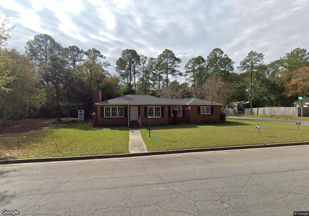
902 12th St E Tifton, GA 31794
Estimated Value: $135,000 - $188,000
3
Beds
2
Baths
1,928
Sq Ft
$85/Sq Ft
Est. Value
About This Home
This home is located at 902 12th St E, Tifton, GA 31794 and is currently estimated at $163,785, approximately $84 per square foot. 902 12th St E is a home located in Tift County with nearby schools including G.O. Bailey Elementary School, Charles Spencer Elementary School, and J.T. Reddick School.
Ownership History
Date
Name
Owned For
Owner Type
Purchase Details
Closed on
Mar 9, 2011
Sold by
Birmelin Robert C
Bought by
Birmelin Robert C and Birmelin Astrid
Current Estimated Value
Purchase Details
Closed on
Aug 9, 2010
Sold by
Engle Paul
Bought by
Deutsche Bank National Trust Company
Purchase Details
Closed on
Mar 1, 2004
Sold by
Rooks Terrie J
Bought by
Engle Paul and Engle Reta J
Purchase Details
Closed on
Feb 25, 2004
Sold by
Rooks Lillian J
Bought by
Rooks Terri J
Purchase Details
Closed on
Jun 6, 2002
Sold by
Rooks Lillian J
Bought by
Rooks Terri J
Purchase Details
Closed on
Dec 14, 1999
Sold by
Rooks Terrie J
Bought by
Rooks Lillian J
Purchase Details
Closed on
Dec 27, 1996
Bought by
Rooks Terrie J
Purchase Details
Closed on
Jun 29, 1951
Bought by
Rooks Leonard A
Create a Home Valuation Report for This Property
The Home Valuation Report is an in-depth analysis detailing your home's value as well as a comparison with similar homes in the area
Home Values in the Area
Average Home Value in this Area
Purchase History
| Date | Buyer | Sale Price | Title Company |
|---|---|---|---|
| Birmelin Robert C | -- | -- | |
| Birmelin Robert | $39,000 | -- | |
| Deutsche Bank National Trust Company | -- | -- | |
| Engle Paul | -- | -- | |
| Engle Paul | $90,000 | -- | |
| Rooks Terri J | -- | -- | |
| Rooks Terri J | -- | -- | |
| Rooks Lillian J | -- | -- | |
| Rooks Terrie J | -- | -- | |
| Rooks Leonard A | -- | -- |
Source: Public Records
Tax History Compared to Growth
Tax History
| Year | Tax Paid | Tax Assessment Tax Assessment Total Assessment is a certain percentage of the fair market value that is determined by local assessors to be the total taxable value of land and additions on the property. | Land | Improvement |
|---|---|---|---|---|
| 2024 | $1,129 | $47,692 | $4,503 | $43,189 |
| 2023 | $1,162 | $30,876 | $6,336 | $24,540 |
| 2022 | $1,162 | $30,876 | $6,336 | $24,540 |
| 2021 | $1,170 | $30,876 | $6,336 | $24,540 |
| 2020 | $1,199 | $30,876 | $6,336 | $24,540 |
| 2019 | $1,199 | $30,876 | $6,336 | $24,540 |
| 2018 | $1,199 | $30,876 | $6,336 | $24,540 |
| 2017 | $1,230 | $30,876 | $6,336 | $24,540 |
| 2016 | $1,232 | $30,876 | $6,336 | $24,540 |
| 2015 | $1,234 | $30,876 | $6,336 | $24,540 |
| 2014 | $1,235 | $30,876 | $6,336 | $24,540 |
| 2013 | -- | $30,876 | $6,336 | $24,540 |
Source: Public Records
Map
Nearby Homes
- 1003 Davis Ave
- 1430 Madison Ave
- 724 6th 1 2 St
- 724 6th 1 2 St Unit 22
- 722 6th 1 2 St
- 620 Prince Ave
- 409 Davis Ave
- 0 Ferry Lake Rd
- 1137 Oquinn Dr
- 810 Tift Ave N
- 33 Oquinn Rd
- 618 Tift Ave N
- 0 44th & 46th St Lots Unit 138029
- 0 Tift Ave
- 219 Cypress Ridge Rd
- - Us Highway 319 S @ Old Omega Rd
- 566 Osprey Cir
- Tract 1 U S 319
- Tract 3 U S 319
- Tract 2 U S 319