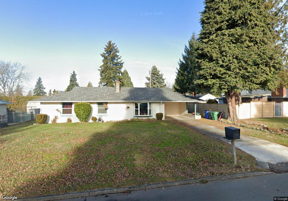
9024 Silver Star Ave Vancouver, WA 98664
Vancouver Heights NeighborhoodEstimated Value: $384,477 - $414,000
3
Beds
1
Bath
1,092
Sq Ft
$367/Sq Ft
Est. Value
About This Home
This home is located at 9024 Silver Star Ave, Vancouver, WA 98664 and is currently estimated at $400,369, approximately $366 per square foot. 9024 Silver Star Ave is a home located in Clark County with nearby schools including George C. Marshall Elementary School, McLoughlin Middle School, and Fort Vancouver High School.
Ownership History
Date
Name
Owned For
Owner Type
Purchase Details
Closed on
Dec 3, 1998
Sold by
Edwards Shirley L
Bought by
Polson Pacharee G
Current Estimated Value
Home Financials for this Owner
Home Financials are based on the most recent Mortgage that was taken out on this home.
Original Mortgage
$75,600
Outstanding Balance
$17,232
Interest Rate
6.82%
Estimated Equity
$383,137
Create a Home Valuation Report for This Property
The Home Valuation Report is an in-depth analysis detailing your home's value as well as a comparison with similar homes in the area
Home Values in the Area
Average Home Value in this Area
Purchase History
| Date | Buyer | Sale Price | Title Company |
|---|---|---|---|
| Polson Pacharee G | $94,500 | First American Title Ins Co |
Source: Public Records
Mortgage History
| Date | Status | Borrower | Loan Amount |
|---|---|---|---|
| Open | Polson Pacharee G | $75,600 |
Source: Public Records
Tax History Compared to Growth
Tax History
| Year | Tax Paid | Tax Assessment Tax Assessment Total Assessment is a certain percentage of the fair market value that is determined by local assessors to be the total taxable value of land and additions on the property. | Land | Improvement |
|---|---|---|---|---|
| 2025 | $3,558 | $377,443 | $194,443 | $183,000 |
| 2024 | $3,461 | $362,677 | $194,443 | $168,234 |
| 2023 | $3,365 | $367,863 | $194,443 | $173,420 |
| 2022 | $3,115 | $359,284 | $194,443 | $164,841 |
| 2021 | $2,777 | $309,712 | $167,623 | $142,089 |
| 2020 | $2,526 | $260,238 | $122,918 | $137,320 |
| 2019 | $2,302 | $245,192 | $113,358 | $131,834 |
| 2018 | $2,417 | $231,335 | $0 | $0 |
| 2017 | $2,123 | $201,890 | $0 | $0 |
| 2016 | $1,925 | $184,864 | $0 | $0 |
| 2015 | $1,855 | $160,062 | $0 | $0 |
| 2014 | -- | $145,740 | $0 | $0 |
| 2013 | -- | $121,073 | $0 | $0 |
Source: Public Records
Map
Nearby Homes
- 9020 Boulder Ave
- 409 SE 95th Ave
- 410 SE 96th Ave
- 8607 Mount Thielson Ave
- 803 SE 94th Ave
- 9012 Mt Lassen Ave
- 220 N Lieser Rd
- 410 SE 100th Ave
- 1040 SE Columbia Ridge Dr Unit 2
- 300 Baltimore Way
- 8318 SE Middle Way
- 604 NE 98th Ct
- 9824 NE Tanglewood Dr
- 515 SE 102nd Ave
- 8014 SE Middle Way
- 10305 St Helens Ave
- 1504 SE 86th Ct
- 1511 SE 86th Ct
- 1323 SE Columbia Crest Ct
- 9008 NE 11th St
- 9016 Silver Star Ave
- 310 Mt Shasta Dr
- 9021 Boulder Ave
- 9017 Boulder Ave
- 9025 Boulder Ave
- 9008 Silver Star Ave
- 9025 Silver Star Ave
- 9033 Silver Star Ave
- 9009 Boulder Ave
- 9009 Silver Star Ave
- 305 Mt Shasta Dr
- 9000 Silver Star Ave
- 303 Mt Shasta Dr
- 9001 Boulder Ave
- 405 Mount Shasta Dr
- 405 Mt Shasta Dr
- 9024 Mt Baker Ave
- 9032 Mt Baker Ave
- 9016 Mt Baker Ave
- 8925 Silver Star Ave