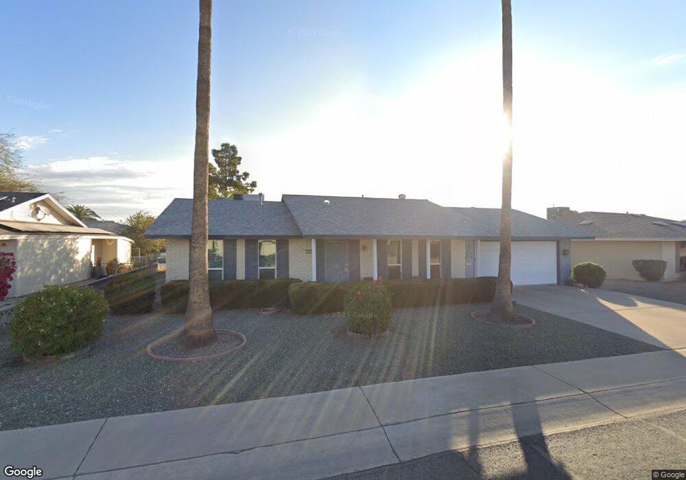
9027 N 102nd Dr Sun City, AZ 85351
Estimated Value: $217,044 - $287,000
2
Beds
2
Baths
1,385
Sq Ft
$191/Sq Ft
Est. Value
About This Home
This home is located at 9027 N 102nd Dr, Sun City, AZ 85351 and is currently estimated at $264,011, approximately $190 per square foot. 9027 N 102nd Dr is a home located in Maricopa County with nearby schools including Ombudsman - Northwest Charter and Peoria Accelerated High School.
Ownership History
Date
Name
Owned For
Owner Type
Purchase Details
Closed on
Jan 27, 2009
Sold by
Carter Charlotte
Bought by
Carter Charlotte J and Charlotte J Carter Trust
Current Estimated Value
Purchase Details
Closed on
Nov 13, 2003
Sold by
Adams John Q and Adams Patsy L
Bought by
Carter Charles F and Carter Charlotte
Purchase Details
Closed on
Nov 27, 1998
Sold by
Adams John Q and Adams Patsy L
Bought by
Adams John Q and Adams Patsy L
Purchase Details
Closed on
Jun 4, 1998
Sold by
Peterson Karl R and Peterson Ruth S
Bought by
Adams John Q and Adams Patsy L
Home Financials for this Owner
Home Financials are based on the most recent Mortgage that was taken out on this home.
Original Mortgage
$72,000
Interest Rate
7.11%
Mortgage Type
New Conventional
Purchase Details
Closed on
Mar 29, 1995
Sold by
Virkus Fred P
Bought by
Peterson Karl R and Peterson Ruth S
Create a Home Valuation Report for This Property
The Home Valuation Report is an in-depth analysis detailing your home's value as well as a comparison with similar homes in the area
Home Values in the Area
Average Home Value in this Area
Purchase History
| Date | Buyer | Sale Price | Title Company |
|---|---|---|---|
| Carter Charlotte J | -- | None Available | |
| Carter Charles F | $117,000 | First American Title Ins Co | |
| Adams John Q | -- | -- | |
| Adams John Q | $90,000 | Security Title Agency | |
| Peterson Karl R | $75,000 | -- |
Source: Public Records
Mortgage History
| Date | Status | Borrower | Loan Amount |
|---|---|---|---|
| Previous Owner | Adams John Q | $72,000 |
Source: Public Records
Tax History Compared to Growth
Tax History
| Year | Tax Paid | Tax Assessment Tax Assessment Total Assessment is a certain percentage of the fair market value that is determined by local assessors to be the total taxable value of land and additions on the property. | Land | Improvement |
|---|---|---|---|---|
| 2025 | $787 | $9,681 | -- | -- |
| 2024 | $709 | $9,220 | -- | -- |
| 2023 | $709 | $18,480 | $3,690 | $14,790 |
| 2022 | $660 | $14,400 | $2,880 | $11,520 |
| 2021 | $682 | $13,280 | $2,650 | $10,630 |
| 2020 | $663 | $11,530 | $2,300 | $9,230 |
| 2019 | $661 | $10,610 | $2,120 | $8,490 |
| 2018 | $638 | $9,470 | $1,890 | $7,580 |
| 2017 | $614 | $8,310 | $1,660 | $6,650 |
| 2016 | $574 | $7,720 | $1,540 | $6,180 |
| 2015 | $549 | $6,920 | $1,380 | $5,540 |
Source: Public Records
Map
Nearby Homes
- 10201 W Caron Dr
- 10326 W Caron Dr
- 10001 W Caron Dr Unit 8
- 10221 W Puget Ave
- 10014 W Mission Ln
- 10109 W Mountain View Rd
- 9815 N 103rd Ave
- 10022 W Mountain View Rd
- 10316 W Salem Dr Unit 6D
- 9925 W Mountain View Rd Unit 27
- 9915 W Mountain View Rd
- 10166 W Cinnebar Ave
- 10302 W Cheryl Dr Unit D
- 9834 N Balboa Dr
- 8803 N 105th Dr
- 10131 W Cheryl Dr Unit 6D
- 8601 N 103rd Ave Unit 313
- 8601 N 103rd Ave Unit 271
- 8601 N 103rd Ave Unit 58
- 8601 N 103rd Ave Unit 72
- 9035 N 102nd Dr
- 9021 N 102nd Dr Unit 8
- 9032 N 102nd Ave
- 9032 N 102nd Dr
- 9032 N 102nd Dr
- 9026 N 102nd Dr
- 9026 N 102nd Dr
- 9040 N 102nd Ave
- 10212 W Caron Dr
- 9022 N 102nd Dr
- 10208 W Caron Dr
- 9038 N 102nd Dr
- 10218 W Kelso Dr
- 9016 N 102nd Dr
- 10210 W Kelso Dr Unit 8
- 10202 W Caron Dr
- 9044 N 102nd Dr
- 10221 W Caron Dr
- 9031 N 103rd Ave
- 9037 N 103rd Ave