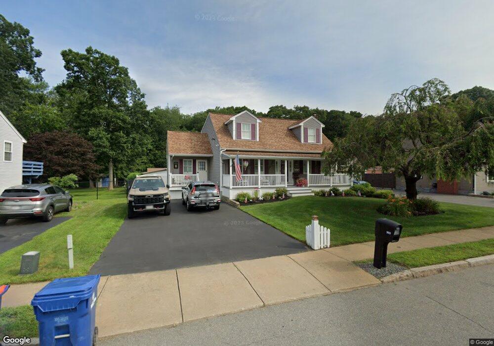
903 Phillips Rd New Bedford, MA 02745
Acushnet-Pine Hill NeighborhoodEstimated Value: $539,000 - $580,695
3
Beds
2
Baths
1,735
Sq Ft
$325/Sq Ft
Est. Value
About This Home
This home is located at 903 Phillips Rd, New Bedford, MA 02745 and is currently estimated at $563,424, approximately $324 per square foot. 903 Phillips Rd is a home located in Bristol County with nearby schools including Casimir Pulaski Elementary School, Normandin Middle School, and New Bedford High School.
Ownership History
Date
Name
Owned For
Owner Type
Purchase Details
Closed on
Jan 20, 1994
Sold by
Phillip North T and Sylvia Kenneth J
Bought by
Sobolewski Edward S and Sobolewski Deborah A
Current Estimated Value
Home Financials for this Owner
Home Financials are based on the most recent Mortgage that was taken out on this home.
Original Mortgage
$100,000
Interest Rate
7.08%
Mortgage Type
Purchase Money Mortgage
Create a Home Valuation Report for This Property
The Home Valuation Report is an in-depth analysis detailing your home's value as well as a comparison with similar homes in the area
Home Values in the Area
Average Home Value in this Area
Purchase History
| Date | Buyer | Sale Price | Title Company |
|---|---|---|---|
| Sobolewski Edward S | $42,000 | -- | |
| Sobolewski Edward S | $42,000 | -- |
Source: Public Records
Mortgage History
| Date | Status | Borrower | Loan Amount |
|---|---|---|---|
| Open | Sobolewski Edward S | $100,000 | |
| Closed | Sobolewski Edward S | $100,000 | |
| Closed | Sobolewski Edward S | $138,515 | |
| Closed | Sobolewski Edward S | $100,000 |
Source: Public Records
Tax History Compared to Growth
Tax History
| Year | Tax Paid | Tax Assessment Tax Assessment Total Assessment is a certain percentage of the fair market value that is determined by local assessors to be the total taxable value of land and additions on the property. | Land | Improvement |
|---|---|---|---|---|
| 2025 | $6,330 | $559,700 | $158,400 | $401,300 |
| 2024 | $6,296 | $524,700 | $148,500 | $376,200 |
| 2023 | $6,856 | $479,800 | $126,300 | $353,500 |
| 2022 | $6,371 | $410,000 | $126,300 | $283,700 |
| 2021 | $6,197 | $397,500 | $123,800 | $273,700 |
| 2020 | $6,152 | $380,700 | $123,800 | $256,900 |
| 2019 | $6,010 | $364,900 | $123,800 | $241,100 |
| 2018 | $5,671 | $341,000 | $123,800 | $217,200 |
| 2017 | $5,342 | $320,100 | $121,300 | $198,800 |
| 2016 | $4,853 | $294,300 | $111,400 | $182,900 |
| 2015 | $4,477 | $284,600 | $108,900 | $175,700 |
| 2014 | $4,296 | $283,400 | $111,400 | $172,000 |
Source: Public Records
Map
Nearby Homes
- 2981 Acushnet Ave
- ES Acushnet Ave
- 26 Rounseville St
- 1023 Bowles St
- 957 Glen St
- 1044 Phillips Rd Unit 20
- 1044 Phillips Rd Unit 24
- 847 Terry Ln
- 850 Terry Ln
- 1044 Victoria St Unit B-29
- 0 Church Dutton & Chaffee Unit 73371719
- 1045 Forbes St
- 1214 Church St
- 1158 Joyce St
- 1164 Victoria St
- 1251 Church St Unit 10
- 1261 Church St Unit 70
- 1261 Church St Unit 46
- 1261 Church St Unit 53
- 1269 Bartlett St
- 897 Phillips Rd
- 911 Phillips Rd
- 889 Phillips Rd
- 919 Phillips Rd
- 883 Phillips Rd
- 894 Phillips Rd
- 925 Phillips Rd
- 904 Phillips Rd
- 910 Phillips Rd
- 888 Phillips Rd
- 889 Bartlett St
- 877 Phillips Rd
- 918 Phillips Rd
- 920 Lucy St
- 276 Fitzgerald Dr
- 914 Lucy St
- 926 Lucy St
- 883 Bartlett St
- 939 Phillips Rd
- 877 Bartlett St