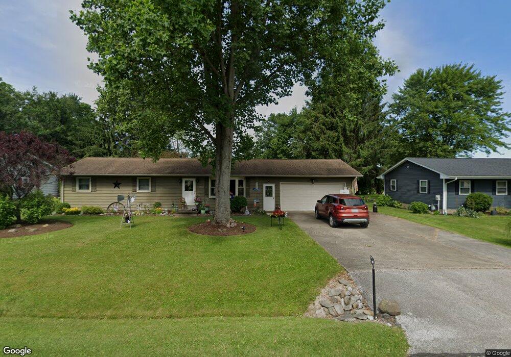
9030 Paula Way Mc Kean, PA 16426
Estimated Value: $215,000 - $243,000
3
Beds
2
Baths
1,104
Sq Ft
$205/Sq Ft
Est. Value
About This Home
This home is located at 9030 Paula Way, Mc Kean, PA 16426 and is currently estimated at $226,524, approximately $205 per square foot. 9030 Paula Way is a home located in Erie County with nearby schools including McKean Elementary School, James W. Parker Middle School, and General McLane High School.
Ownership History
Date
Name
Owned For
Owner Type
Purchase Details
Closed on
Feb 8, 2023
Sold by
Defelice Betty J
Bought by
Walsh Tracy L
Current Estimated Value
Purchase Details
Closed on
May 8, 2009
Sold by
Robinson Mark and Robinson Kaye
Bought by
Defelice Ralph N and Defelice Betty J
Purchase Details
Closed on
May 3, 2005
Sold by
Estate Of Ronald Price and Price R Matthew
Bought by
Robinson Mark and Robinson Kaye
Home Financials for this Owner
Home Financials are based on the most recent Mortgage that was taken out on this home.
Original Mortgage
$80,000
Interest Rate
6.05%
Mortgage Type
Fannie Mae Freddie Mac
Purchase Details
Closed on
Jul 25, 1997
Sold by
Szymanowicz John R and Szymanowicz Henrietta M
Bought by
Price Ronald
Create a Home Valuation Report for This Property
The Home Valuation Report is an in-depth analysis detailing your home's value as well as a comparison with similar homes in the area
Home Values in the Area
Average Home Value in this Area
Purchase History
| Date | Buyer | Sale Price | Title Company |
|---|---|---|---|
| Walsh Tracy L | -- | -- | |
| Defelice Ralph N | $115,000 | None Available | |
| Robinson Mark | $100,000 | -- | |
| Price Ronald | $89,700 | -- |
Source: Public Records
Mortgage History
| Date | Status | Borrower | Loan Amount |
|---|---|---|---|
| Previous Owner | Robinson Mark | $80,000 | |
| Closed | Robinson Mark | $20,000 |
Source: Public Records
Tax History Compared to Growth
Tax History
| Year | Tax Paid | Tax Assessment Tax Assessment Total Assessment is a certain percentage of the fair market value that is determined by local assessors to be the total taxable value of land and additions on the property. | Land | Improvement |
|---|---|---|---|---|
| 2025 | $2,732 | $120,050 | $31,500 | $88,550 |
| 2024 | $2,646 | $120,050 | $31,500 | $88,550 |
| 2023 | $2,490 | $120,050 | $31,500 | $88,550 |
| 2022 | $2,418 | $120,050 | $31,500 | $88,550 |
| 2021 | $2,387 | $120,050 | $31,500 | $88,550 |
| 2020 | $2,357 | $120,050 | $31,500 | $88,550 |
| 2019 | $2,341 | $120,050 | $31,500 | $88,550 |
| 2018 | $2,291 | $120,050 | $31,500 | $88,550 |
| 2017 | $2,291 | $120,050 | $31,500 | $88,550 |
| 2016 | $2,691 | $120,050 | $31,500 | $88,550 |
| 2015 | $2,661 | $120,050 | $31,500 | $88,550 |
| 2014 | $1,297 | $120,050 | $31,500 | $88,550 |
Source: Public Records
Map
Nearby Homes
- 5115 West Rd
- 11897 Silverthorn (Tr 86 Rt T438) Rd
- 0 Edinboro Rd Unit 182375
- 4954 East Ave
- 702 Skyline Dr
- 4854 N Main St
- 209 Timberlake Dr
- 6330 Rick Rd
- 8580 Rick Rd
- 15 Woodside Dr
- 8389 Edinboro Rd
- 6797 Sterrettania Rd
- 6419 Sterrettania Rd
- 2880 Cardinal Dr Unit 34
- 2800 Sun Ridge Dr
- 0 Pagan Rd
- 5472 Granite Ln
- 8535 Oliver Rd
- 9731 Silverthorn Rd
- 4385 Stone Creek Dr