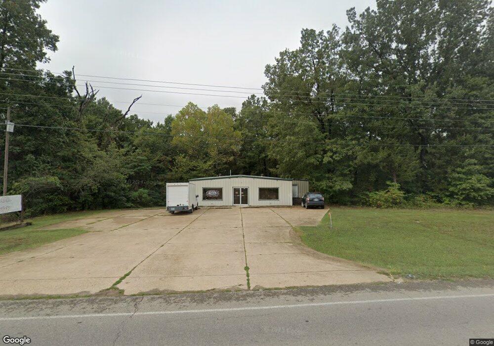
904 E Main St Flippin, AR 72634
Estimated Value: $154,282
Studio
1
Bath
2,300
Sq Ft
$67/Sq Ft
Est. Value
About This Home
This home is located at 904 E Main St, Flippin, AR 72634 and is currently estimated at $154,282, approximately $67 per square foot. 904 E Main St is a home located in Marion County with nearby schools including Flippin Elementary School, Flippin Middle School, and Flippin High School.
Ownership History
Date
Name
Owned For
Owner Type
Purchase Details
Closed on
Jun 1, 2022
Bought by
Onepineapplewatermelon Llc
Current Estimated Value
Purchase Details
Closed on
Sep 26, 2019
Sold by
Bryant Curtis and Bryant Joan
Bought by
Rockin T Llc
Home Financials for this Owner
Home Financials are based on the most recent Mortgage that was taken out on this home.
Original Mortgage
$129,380
Interest Rate
3.5%
Mortgage Type
Commercial
Purchase Details
Closed on
Feb 6, 2004
Bought by
Bryant and Bryant Smith
Purchase Details
Closed on
Oct 9, 1997
Bought by
Curtis
Create a Home Valuation Report for This Property
The Home Valuation Report is an in-depth analysis detailing your home's value as well as a comparison with similar homes in the area
Purchase History
| Date | Buyer | Sale Price | Title Company |
|---|---|---|---|
| Onepineapplewatermelon Llc | $131,000 | -- | |
| Rockin T Llc | $170,000 | None Available | |
| Bryant | $140,000 | -- | |
| Curtis | $27,000 | -- |
Source: Public Records
Mortgage History
| Date | Status | Borrower | Loan Amount |
|---|---|---|---|
| Previous Owner | Rockin T Llc | $129,380 |
Source: Public Records
Tax History
| Year | Tax Paid | Tax Assessment Tax Assessment Total Assessment is a certain percentage of the fair market value that is determined by local assessors to be the total taxable value of land and additions on the property. | Land | Improvement |
|---|---|---|---|---|
| 2025 | $1,560 | $33,340 | $5,400 | $27,940 |
| 2024 | $1,584 | $33,340 | $5,400 | $27,940 |
| 2023 | $1,584 | $33,340 | $5,400 | $27,940 |
| 2022 | $1,465 | $33,340 | $5,400 | $27,940 |
| 2021 | $1,342 | $33,340 | $5,400 | $27,940 |
| 2020 | $1,220 | $25,680 | $5,400 | $20,280 |
| 2019 | $1,238 | $25,680 | $5,400 | $20,280 |
| 2018 | $1,238 | $25,680 | $5,400 | $20,280 |
| 2017 | $1,074 | $25,680 | $5,400 | $20,280 |
| 2016 | $1,074 | $22,610 | $5,400 | $17,210 |
| 2015 | $976 | $20,550 | $5,400 | $15,150 |
| 2014 | -- | $20,550 | $5,400 | $15,150 |
| 2013 | -- | $20,550 | $5,400 | $15,150 |
| 2012 | -- | $20,550 | $5,400 | $15,150 |
Source: Public Records
Map
Nearby Homes
- 770 05121 000 Hwy 62 412 E
- 770-05063-000 8th St
- 00 8th St
- 121 E Industrial Park
- 121 E Industrial Park
- 604 1/2 Girard St
- 304 South St
- 770-05769-000 E Hwy 62
- 203 South St
- 207 N 2nd St
- 0 Lydia Ln
- 121 W Industrial Park Rd
- 001-01932-000 Marion County 7055
- 527-00000-000 Lydia Ln
- 2674 Mc 7055
- 6577 Arkansas 202
- 130 Wildcat Berry Ln
- 373 Marion County 7050
- 5638 Arkansas 202
- 154 Marion County 7091
Your Personal Tour Guide
Ask me questions while you tour the home.