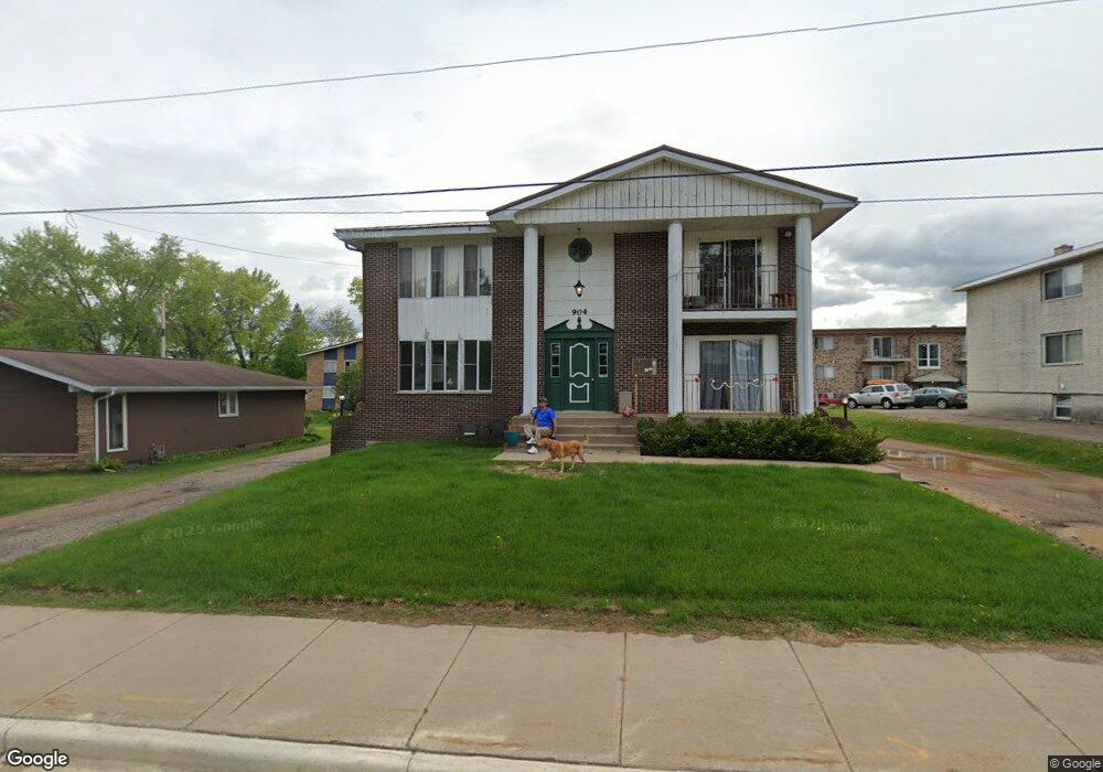
904 Main St Mosinee, WI 54455
Estimated Value: $1,003,802
11
Beds
6
Baths
--
Sq Ft
10,629
Sq Ft Lot
About This Home
This home is located at 904 Main St, Mosinee, WI 54455 and is currently priced at $1,003,802. 904 Main St is a home located in Marathon County with nearby schools including Mosinee Elementary School, Mosinee Middle School, and Mosinee High School.
Ownership History
Date
Name
Owned For
Owner Type
Purchase Details
Closed on
Jul 23, 2024
Sold by
Gau Vincent L and Gau Debbie J
Bought by
Homestead Homes North Llc
Current Estimated Value
Home Financials for this Owner
Home Financials are based on the most recent Mortgage that was taken out on this home.
Original Mortgage
$800,000
Outstanding Balance
$787,569
Interest Rate
6.99%
Mortgage Type
New Conventional
Create a Home Valuation Report for This Property
The Home Valuation Report is an in-depth analysis detailing your home's value as well as a comparison with similar homes in the area
Home Values in the Area
Average Home Value in this Area
Purchase History
| Date | Buyer | Sale Price | Title Company |
|---|---|---|---|
| Homestead Homes North Llc | $1,000,000 | Avenue Title Services |
Source: Public Records
Mortgage History
| Date | Status | Borrower | Loan Amount |
|---|---|---|---|
| Open | Homestead Homes North Llc | $800,000 |
Source: Public Records
Tax History
| Year | Tax Paid | Tax Assessment Tax Assessment Total Assessment is a certain percentage of the fair market value that is determined by local assessors to be the total taxable value of land and additions on the property. | Land | Improvement |
|---|---|---|---|---|
| 2025 | $4,505 | $226,500 | $20,400 | $206,100 |
| 2024 | $2,187 | $226,500 | $20,400 | $206,100 |
| 2023 | $4,222 | $226,500 | $20,400 | $206,100 |
| 2022 | $3,843 | $226,500 | $20,400 | $206,100 |
| 2021 | $3,626 | $157,800 | $20,400 | $137,400 |
| 2020 | $3,621 | $157,800 | $20,400 | $137,400 |
| 2019 | $3,559 | $157,800 | $20,400 | $137,400 |
| 2018 | $3,613 | $157,800 | $20,400 | $137,400 |
| 2017 | $3,562 | $157,800 | $20,400 | $137,400 |
| 2016 | $3,502 | $157,800 | $20,400 | $137,400 |
| 2015 | $3,402 | $157,800 | $20,400 | $137,400 |
| 2014 | $3,354 | $157,800 | $20,400 | $137,400 |
Source: Public Records
Map
Nearby Homes
- 307 Washington St
- 707 5th St
- 604 15th St
- 1003 W 4th St
- 1701 Jackson St
- 804 Rangeline Rd
- 1317 Mink Rd
- .85 acres Lorrel St
- 1.5 Acres State Hghway 153
- 793-795 Fairway Dr
- 831 Fairway Dr
- 812 Pinedale Ln
- Lot 5 Acorn Ridge Rd
- Lot 3 Acorn Ridge Rd
- Lot 6 Acorn Ridge Rd
- Lots 3, 5, 6 Acorn Ridge Rd
- 146117 Moon Rd
- 1066 Maple Ridge Rd
- 207990 Kris Ln
- 145250 Burma Rd
Your Personal Tour Guide
Ask me questions while you tour the home.