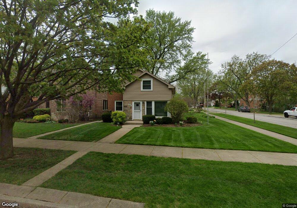
9044 Menard Ave Morton Grove, IL 60053
Estimated Value: $360,000 - $376,000
3
Beds
1
Bath
837
Sq Ft
$440/Sq Ft
Est. Value
About This Home
This home is located at 9044 Menard Ave, Morton Grove, IL 60053 and is currently estimated at $368,443, approximately $440 per square foot. 9044 Menard Ave is a home located in Cook County with nearby schools including Park View Elementary School and Niles West High School.
Ownership History
Date
Name
Owned For
Owner Type
Purchase Details
Closed on
Mar 16, 2012
Sold by
Rymut Bock Phillip A and Rymut Bock Laura C
Bought by
Declaration Bock Laura C Rymut and Laura C Rymut Bock Declaration Of Trust
Current Estimated Value
Purchase Details
Closed on
Nov 30, 1994
Sold by
Thurlwell Marion A
Bought by
Bock Phillip A and Rymut Laura C
Home Financials for this Owner
Home Financials are based on the most recent Mortgage that was taken out on this home.
Original Mortgage
$150,000
Interest Rate
7.75%
Create a Home Valuation Report for This Property
The Home Valuation Report is an in-depth analysis detailing your home's value as well as a comparison with similar homes in the area
Home Values in the Area
Average Home Value in this Area
Purchase History
| Date | Buyer | Sale Price | Title Company |
|---|---|---|---|
| Declaration Bock Laura C Rymut | -- | None Available | |
| Bock Phillip A | $158,000 | -- |
Source: Public Records
Mortgage History
| Date | Status | Borrower | Loan Amount |
|---|---|---|---|
| Previous Owner | Bock Phillip A | $150,000 |
Source: Public Records
Tax History Compared to Growth
Tax History
| Year | Tax Paid | Tax Assessment Tax Assessment Total Assessment is a certain percentage of the fair market value that is determined by local assessors to be the total taxable value of land and additions on the property. | Land | Improvement |
|---|---|---|---|---|
| 2024 | $8,087 | $28,000 | $8,520 | $19,480 |
| 2023 | $7,706 | $28,000 | $8,520 | $19,480 |
| 2022 | $7,706 | $28,000 | $8,520 | $19,480 |
| 2021 | $6,615 | $20,623 | $5,243 | $15,380 |
| 2020 | $6,439 | $20,623 | $5,243 | $15,380 |
| 2019 | $6,488 | $23,172 | $5,243 | $17,929 |
| 2018 | $6,246 | $19,794 | $4,751 | $15,043 |
| 2017 | $6,293 | $19,794 | $4,751 | $15,043 |
| 2016 | $5,932 | $19,794 | $4,751 | $15,043 |
| 2015 | $5,931 | $18,404 | $4,096 | $14,308 |
| 2014 | $5,924 | $18,404 | $4,096 | $14,308 |
| 2013 | $5,789 | $18,404 | $4,096 | $14,308 |
Source: Public Records
Map
Nearby Homes
- 9224 Menard Ave
- 8918 Parkside Ave
- 8841 Menard Ave
- 9314 Menard Ave
- 9320 Menard Ave
- 8836 Mansfield Ave
- 9234 Central Ave
- 5644 Lyons St
- 5536 Greenwood St
- 8849 Mcvicker Ave
- 5449 Arcadia St
- 5459 Suffield Ct
- 8708 Central Ave
- 5352 Greenwood St
- 8655 Harms Rd
- 5247 Suffield Ct
- 5309 Crain St
- 8541 Lotus Ave Unit 914
- 6332 Hennings Ct
- 6330 Hennings Ct
- 9040 Menard Ave
- 9036 Menard Ave
- 9102 Menard Ave
- 9034 Menard Ave
- 9045 Mansfield Ave
- 9043 Mansfield Ave
- 9106 Menard Ave
- 9037 Mansfield Ave
- 9028 Menard Ave
- 9103 Mansfield Ave
- 9045 Menard Ave
- 9045 Menard Ave
- 9039 Menard Ave
- 9039 Menard Ave
- 9110 Menard Ave
- 9107 Mansfield Ave
- 9035 Mansfield Ave
- 9101 Menard Ave
- 9101 Menard Ave
- 9026 Menard Ave