
Seller's Agent in 2025
Kim Hyland
Windermere RE Lane County
(541) 513-4884
99 Total Sales
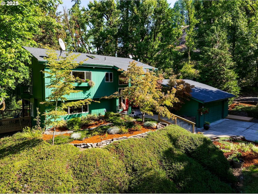
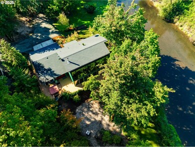
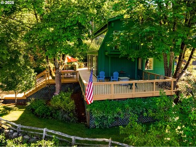
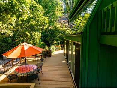


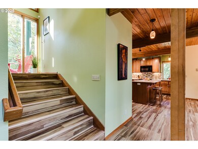
Welcome to your private riverfront retreat—quiet, serene, and beautifully remodeled. A dramatic wall of windows frames sweeping views of the river and golf course, while expansive decks and a balcony off the primary suite invite you to fully savor the outdoors. Picture quiet evenings overlooking the river and watching golfers in the distance. Inside, recent updates include a refreshed kitchen and spa-like primary bath with heated floors, newer roof, foundation stabilization, added insulation, and a new heat pump for year-round comfort. Set on 2.27 acres with raised beds and endless potential, this property offers room to garden, play, or simply breathe. Just 15 minutes from downtown Springfield and 20 from Eugene, it’s the perfect blend of peaceful seclusion and city convenience.
Last Agent to Sell the Property
Windermere RE Lane County Brokerage Phone: 541-513-4884 License #200311110 Listed on: 09/26/2025
| Date | Type | Sale Price | Title Company |
|---|---|---|---|
| Warranty Deed | $725,000 | Cascade Title | |
| Warranty Deed | $395,500 | Fidelity Natl Title Co Of Or | |
| Warranty Deed | $325,000 | Evergreen Land Title Company |
| Date | Status | Loan Amount | Loan Type |
|---|---|---|---|
| Open | $705,000 | VA | |
| Previous Owner | $125,001 | New Conventional | |
| Previous Owner | $208,000 | Balloon |
| Date | Event | Price | List to Sale | Price per Sq Ft |
|---|---|---|---|---|
| 11/03/2025 11/03/25 | Sold | $725,000 | 0.0% | $407 / Sq Ft |
| 10/03/2025 10/03/25 | Pending | -- | -- | -- |
| 09/26/2025 09/26/25 | For Sale | $725,000 | -- | $407 / Sq Ft |
| Year | Tax Paid | Tax Assessment Tax Assessment Total Assessment is a certain percentage of the fair market value that is determined by local assessors to be the total taxable value of land and additions on the property. | Land | Improvement |
|---|---|---|---|---|
| 2025 | $4,072 | $362,990 | -- | -- |
| 2024 | $3,958 | $352,418 | -- | -- |
| 2023 | $3,958 | $342,154 | $0 | $0 |
| 2022 | $3,695 | $332,189 | $0 | $0 |
| 2021 | $3,608 | $322,514 | $0 | $0 |
| 2020 | $3,499 | $313,121 | $0 | $0 |
| 2019 | $3,210 | $289,541 | $0 | $0 |
| 2018 | $3,102 | $272,920 | $0 | $0 |
| 2017 | $2,877 | $272,920 | $0 | $0 |
| 2016 | $2,801 | $264,971 | $0 | $0 |
| 2015 | $2,727 | $257,253 | $0 | $0 |
| 2014 | $2,642 | $249,760 | $0 | $0 |
Seller's Agent in 2025
Kim Hyland
Windermere RE Lane County
(541) 513-4884
99 Total Sales
Buyer's Agent in 2025
Xander Taylor
Taylor Made Real Estate
(541) 729-3632
80 Total Sales
Source: Regional Multiple Listing Service (RMLS)
MLS Number: 138506630
APN: 1273299
Disclaimer: Certain information contained herein is derived from information provided by parties other than Homes.com. All information provided is deemed reliable, but is not guaranteed to be accurate and should be independently verified.
![]() The content relating to real estate for sale on this web site comes in part from the IDX program of the RMLS™ of Portland, Oregon. Real estate listings held by brokerage firms other than Ten-X are marked with the RMLS™ logo, and detailed information about these properties includes the names of the listing brokers. Listing content is copyright © 2026 RMLS™, Portland, Oregon. Some properties which appear for sale on this web site may subsequently have sold or may no longer be available. All information provided is deemed reliable but is not guaranteed and should be independently verified.
The content relating to real estate for sale on this web site comes in part from the IDX program of the RMLS™ of Portland, Oregon. Real estate listings held by brokerage firms other than Ten-X are marked with the RMLS™ logo, and detailed information about these properties includes the names of the listing brokers. Listing content is copyright © 2026 RMLS™, Portland, Oregon. Some properties which appear for sale on this web site may subsequently have sold or may no longer be available. All information provided is deemed reliable but is not guaranteed and should be independently verified.
Ask me questions while you tour the home.