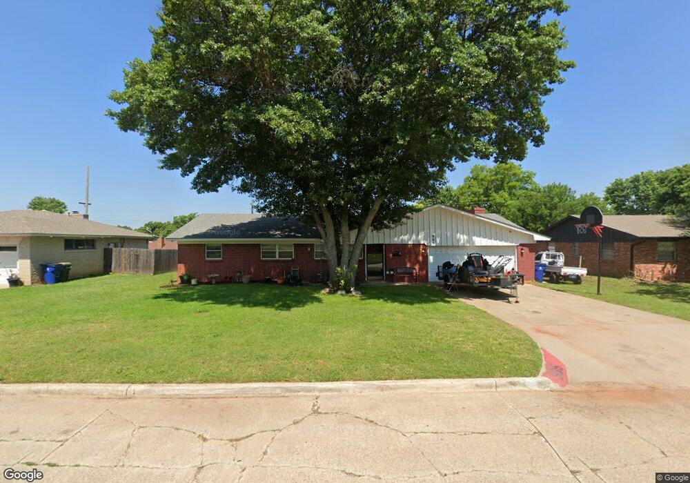
905 N Alice Dr Duncan, OK 73533
Estimated Value: $152,000 - $171,835
3
Beds
2
Baths
1,828
Sq Ft
$90/Sq Ft
Est. Value
About This Home
This home is located at 905 N Alice Dr, Duncan, OK 73533 and is currently estimated at $163,959, approximately $89 per square foot. 905 N Alice Dr is a home located in Stephens County with nearby schools including Horace Mann Elementary School, Duncan Middle School, and Duncan High School.
Ownership History
Date
Name
Owned For
Owner Type
Purchase Details
Closed on
Jun 6, 2024
Sold by
Livingston Calen Matthew and Livingston Brenna
Bought by
Wren Justin and Wren Kelsey
Current Estimated Value
Purchase Details
Closed on
Sep 12, 2023
Sold by
Livingston Calen and Livingston Brenna
Bought by
Wren Justin and Wren Kelsey
Purchase Details
Closed on
May 22, 2020
Sold by
Fields Margie M
Bought by
Livingston Calen M
Create a Home Valuation Report for This Property
The Home Valuation Report is an in-depth analysis detailing your home's value as well as a comparison with similar homes in the area
Home Values in the Area
Average Home Value in this Area
Purchase History
| Date | Buyer | Sale Price | Title Company |
|---|---|---|---|
| Wren Justin | $100,000 | None Listed On Document | |
| Wren Justin | -- | None Listed On Document | |
| Livingston Calen M | -- | None Available |
Source: Public Records
Tax History Compared to Growth
Tax History
| Year | Tax Paid | Tax Assessment Tax Assessment Total Assessment is a certain percentage of the fair market value that is determined by local assessors to be the total taxable value of land and additions on the property. | Land | Improvement |
|---|---|---|---|---|
| 2025 | $806 | $13,428 | $1,261 | $12,167 |
| 2024 | $806 | $10,462 | $1,080 | $9,382 |
| 2023 | $806 | $10,666 | $1,103 | $9,563 |
| 2022 | $823 | $10,158 | $1,067 | $9,091 |
| 2021 | $823 | $9,674 | $1,066 | $8,608 |
| 2020 | $585 | $8,775 | $952 | $7,823 |
| 2019 | $586 | $8,775 | $953 | $7,822 |
| 2018 | $759 | $8,775 | $949 | $7,826 |
| 2017 | $697 | $8,520 | $937 | $7,583 |
| 2016 | $657 | $7,728 | $850 | $6,878 |
| 2015 | $557 | $7,359 | $814 | $6,545 |
| 2014 | $557 | $7,359 | $814 | $6,545 |
Source: Public Records
Map
Nearby Homes
- 2230 W Spruce St
- 2206 2206 W Spruce
- 2204 W Parkview Ave
- 1929 W Chisholm Dr
- 2110 W Amhurst Ave
- 507 N Alice Dr
- 2210 Western Dr
- 1212 1212 N 21st
- 1302 N 21st St
- 1099 N 19th St
- 1902 W Randall Ave
- 1311 1311 N 20 St
- 2202 W Canary Ave
- 1807 W Chisholm Dr
- 1244 Carriage Dr
- 2120 2120 Flamingo Ln
- 1385 Smith Rd
- 1359 Smith Rd
- 209 N 22nd St
- 210 N 22nd St
- 1001 N Alice Dr
- 903 N Alice Dr
- 1000 N Harville Rd
- 1002 N Harville Rd
- 906 N Harville Rd
- 1003 N Alice Dr
- 2216 W Parkview Ave
- 1004 N Harville Rd
- 901 901 Alice Dr
- 901 N Alice Dr
- 904 N Harville Rd
- 2217 W Spruce Ave
- 1006 N Harville Rd
- 2214 W Parkview Ave
- 1005 N Alice Dr
- 281184 E 1690 Rd
- 2213 W Parkview Ave
- 2215 W Spruce Ave
- 1006 1006 N Harville
- 902 N Harville Rd