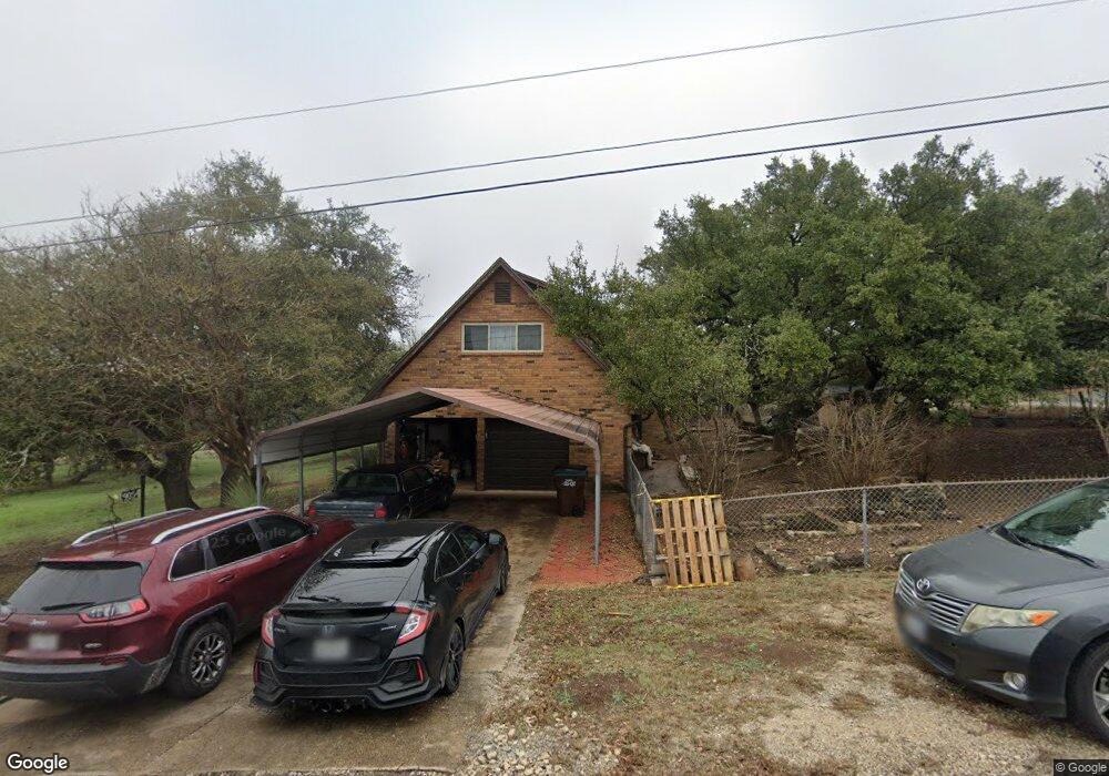
9054 Cap Mountain Dr San Antonio, TX 78255
Cross Mountain NeighborhoodEstimated Value: $506,385 - $651,000
4
Beds
2
Baths
1,978
Sq Ft
$300/Sq Ft
Est. Value
About This Home
This home is located at 9054 Cap Mountain Dr, San Antonio, TX 78255 and is currently estimated at $592,846, approximately $299 per square foot. 9054 Cap Mountain Dr is a home located in Bexar County with nearby schools including Dr. Sara B. McAndrew Elementary School, Rawlinson Middle School, and Clark High School.
Ownership History
Date
Name
Owned For
Owner Type
Purchase Details
Closed on
Jun 23, 2006
Sold by
Salgado Izaura
Bought by
Salgado Lorenzo R and Salgado Rosa E
Current Estimated Value
Purchase Details
Closed on
Aug 3, 2001
Sold by
Mendez Alfred H and Mendez Silvina D
Bought by
Smith Robin and Smith Karen
Home Financials for this Owner
Home Financials are based on the most recent Mortgage that was taken out on this home.
Original Mortgage
$127,600
Interest Rate
7.07%
Create a Home Valuation Report for This Property
The Home Valuation Report is an in-depth analysis detailing your home's value as well as a comparison with similar homes in the area
Home Values in the Area
Average Home Value in this Area
Purchase History
| Date | Buyer | Sale Price | Title Company |
|---|---|---|---|
| Salgado Lorenzo R | -- | None Available | |
| Smith Robin | -- | Ticor Title Agency |
Source: Public Records
Mortgage History
| Date | Status | Borrower | Loan Amount |
|---|---|---|---|
| Previous Owner | Smith Robin | $127,600 |
Source: Public Records
Tax History Compared to Growth
Tax History
| Year | Tax Paid | Tax Assessment Tax Assessment Total Assessment is a certain percentage of the fair market value that is determined by local assessors to be the total taxable value of land and additions on the property. | Land | Improvement |
|---|---|---|---|---|
| 2025 | $1,963 | $529,682 | $129,440 | $411,970 |
| 2024 | $1,963 | $481,529 | $129,440 | $411,990 |
| 2023 | $1,963 | $437,754 | $129,440 | $412,000 |
| 2022 | $7,901 | $397,958 | $110,630 | $412,150 |
| 2021 | $7,453 | $361,780 | $96,200 | $265,580 |
| 2020 | $8,494 | $403,590 | $51,870 | $351,720 |
| 2019 | $8,720 | $400,619 | $51,870 | $351,740 |
| 2018 | $7,929 | $364,199 | $55,580 | $309,470 |
| 2017 | $7,231 | $331,090 | $55,580 | $275,510 |
| 2016 | $7,410 | $339,284 | $54,930 | $287,310 |
| 2015 | $3,497 | $308,440 | $54,930 | $253,510 |
| 2014 | $3,497 | $287,680 | $0 | $0 |
Source: Public Records
Map
Nearby Homes
- 9119 Cap Mountain Dr
- 00 Beartooth Pass
- 8902 Saddle Trail
- 0 Broad Oak Ln
- 8818 Apache Trail
- 24840 Breeze Oak Ln
- 11019 Porter Springs
- 11010 Nina Ridge
- 11309 Sloanes Ridge
- 23314 Cawley Run
- 11107 Kendall Canyon
- 23328 Ebner Ridge
- 11223 Kendall Canyon
- 11212 Kendall Canyon
- 24014 Lydia Ridge
- 11211 Steihler Hill
- 11317 Sloanes Ridge
- 11306 Nina Ridge
- 11313 Sloanes Ridge
- 23511 Basse Canyon
- 9030 Saddle Trail
- 9051 Cap Mountain Dr
- 9080 Cap Mountain Dr
- 9102 Cap Mountain Dr
- 9026 Saddle Trail
- 9102 Saddle Trail
- 9035 Saddle Trail
- 9102 Saddle Trail
- 9112 Cap Mountain Dr
- 9018 Saddle Trail
- 9023 Saddle Trail
- 9106 Saddle Trail
- 9038 Cap Mountain Dr
- 9038 Cap Mountain Dr
- 9111 Saddle Trail
- 23724 Up Mountain Rd
- 23714 Up Mountain Rd
- 9118 Cap Mountain Dr
- 9116 Saddle Trail
- 9011 Saddle Trail