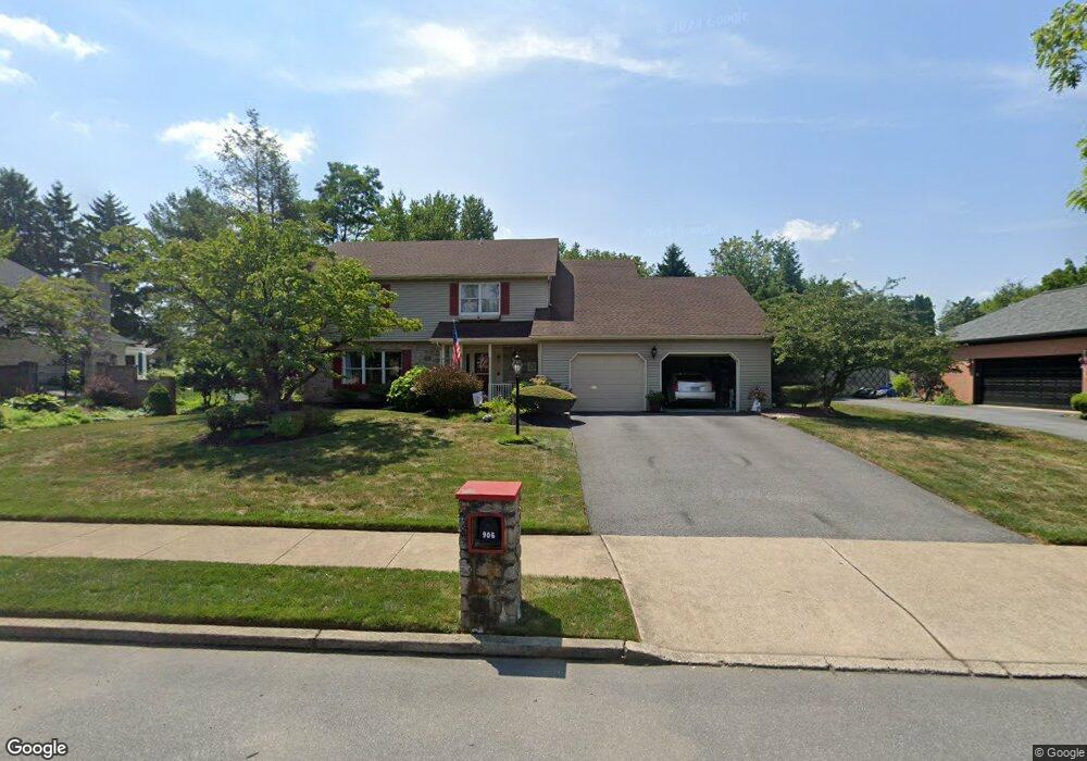
906 Barnsdale Rd Bethlehem, PA 18017
Northeast Bethlehem NeighborhoodEstimated Value: $537,000 - $571,141
4
Beds
3
Baths
2,586
Sq Ft
$214/Sq Ft
Est. Value
About This Home
This home is located at 906 Barnsdale Rd, Bethlehem, PA 18017 and is currently estimated at $552,285, approximately $213 per square foot. 906 Barnsdale Rd is a home located in Northampton County with nearby schools including Spring Garden Elementary School, Northeast Middle School, and Liberty High School.
Ownership History
Date
Name
Owned For
Owner Type
Purchase Details
Closed on
Mar 16, 2007
Sold by
Scharle W Timothy
Bought by
Maya Manuel
Current Estimated Value
Home Financials for this Owner
Home Financials are based on the most recent Mortgage that was taken out on this home.
Original Mortgage
$260,000
Outstanding Balance
$158,577
Interest Rate
6.4%
Mortgage Type
New Conventional
Estimated Equity
$393,708
Purchase Details
Closed on
Nov 26, 2002
Bought by
Scharle W Timothy
Create a Home Valuation Report for This Property
The Home Valuation Report is an in-depth analysis detailing your home's value as well as a comparison with similar homes in the area
Home Values in the Area
Average Home Value in this Area
Purchase History
| Date | Buyer | Sale Price | Title Company |
|---|---|---|---|
| Maya Manuel | $325,000 | -- | |
| Scharle W Timothy | -- | -- |
Source: Public Records
Mortgage History
| Date | Status | Borrower | Loan Amount |
|---|---|---|---|
| Open | Maya Manuel | $260,000 |
Source: Public Records
Tax History Compared to Growth
Tax History
| Year | Tax Paid | Tax Assessment Tax Assessment Total Assessment is a certain percentage of the fair market value that is determined by local assessors to be the total taxable value of land and additions on the property. | Land | Improvement |
|---|---|---|---|---|
| 2025 | $1,145 | $106,000 | $26,400 | $79,600 |
| 2024 | $9,369 | $106,000 | $26,400 | $79,600 |
| 2023 | $9,369 | $106,000 | $26,400 | $79,600 |
| 2022 | $9,296 | $106,000 | $26,400 | $79,600 |
| 2021 | $9,234 | $106,000 | $26,400 | $79,600 |
| 2020 | $9,146 | $106,000 | $26,400 | $79,600 |
| 2019 | $9,115 | $106,000 | $26,400 | $79,600 |
| 2018 | $8,893 | $106,000 | $26,400 | $79,600 |
| 2017 | $8,787 | $106,000 | $26,400 | $79,600 |
| 2016 | -- | $106,000 | $26,400 | $79,600 |
| 2015 | -- | $106,000 | $26,400 | $79,600 |
| 2014 | -- | $106,000 | $26,400 | $79,600 |
Source: Public Records
Map
Nearby Homes
- 1063 Westbury Dr
- 1201 Butztown Rd Unit 1
- 2534 Linden St
- 750 Johnston Dr
- 3042 Artemis Cir
- 938 Meadow Cir
- 3245 Chenault Dr
- 2369 Montgomery St
- 2405 West Blvd
- 2321 Montgomery St
- 3149 Lucas Dr
- 2328 Linden St
- 1740 Butztown Rd
- 2312 Lafayette Ave
- 510 Pine Top Trail
- 1824 Barrett Dr
- 1921 Greenleaf St
- 2860 Center St
- 1736 Falcon Dr
- 2003 Kemmerer St
- 890 Barnsdale Rd
- 912 Barnsdale Rd
- 915 Wafford Ln
- 880 Barnsdale Rd
- 905 Wafford Ln
- 929 Wafford Ln
- 945 Wafford Ln
- 907 Barnsdale Rd
- 928 Barnsdale Rd
- 897 Barnsdale Rd
- 917 Barnsdale Rd
- 895 Wafford Ln
- 870 Barnsdale Rd
- 887 Barnsdale Rd
- 927 Barnsdale Rd
- 885 Wafford Ln
- 875 Barnsdale Rd
- 860 Barnsdale Rd
- 954 Wafford Ln
- 937 Barnsdale Rd