Estimated Value: $73,600 - $103,000
3
Beds
1
Bath
1,120
Sq Ft
$80/Sq Ft
Est. Value
About This Home
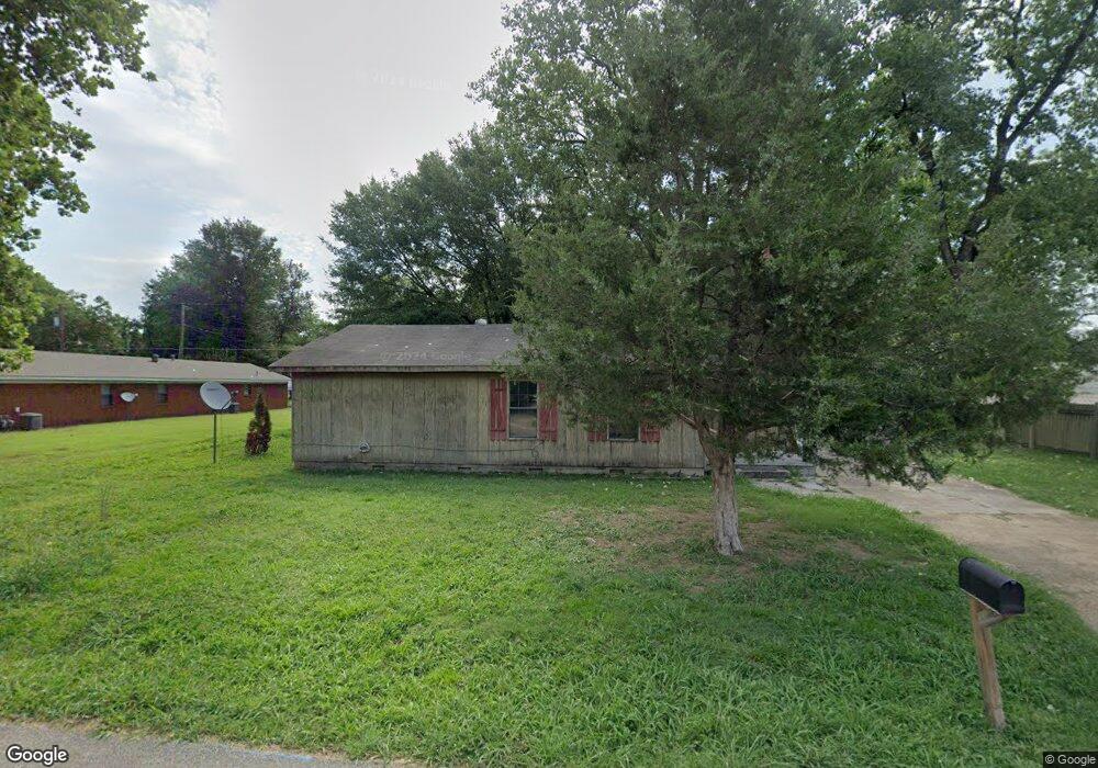
This home is located at 906 Block St S, Wynne, AR 72396 and is currently estimated at $89,400, approximately $79 per square foot. 906 Block St S is a home located in Cross County with nearby schools including Wynne Primary School, Wynne Intermediate School, and Wynne Junior High School.
Ownership History
Date
Name
Owned For
Owner Type
Purchase Details
Closed on
Dec 16, 2020
Sold by
Yates David B
Bought by
Triadd Land Holdings Llc
Current Estimated Value
Home Financials for this Owner
Home Financials are based on the most recent Mortgage that was taken out on this home.
Original Mortgage
$28,475
Outstanding Balance
$1,517
Interest Rate
2.7%
Mortgage Type
Commercial
Estimated Equity
$87,883
Purchase Details
Closed on
Apr 1, 2011
Sold by
Collier Howard and Collier Stephanie
Bought by
Federal National Mortgage Association
Purchase Details
Closed on
Sep 29, 1995
Bought by
Rushing William A
Create a Home Valuation Report for This Property
The Home Valuation Report is an in-depth analysis detailing your home's value as well as a comparison with similar homes in the area
Home Values in the Area
Average Home Value in this Area
Purchase History
| Date | Buyer | Sale Price | Title Company |
|---|---|---|---|
| Triadd Land Holdings Llc | $34,000 | Professional Land Tile Co Of | |
| Federal National Mortgage Association | -- | None Available | |
| Rushing William A | $35,000 | -- |
Source: Public Records
Mortgage History
| Date | Status | Borrower | Loan Amount |
|---|---|---|---|
| Open | Triadd Land Holdings Llc | $28,475 |
Source: Public Records
Tax History Compared to Growth
Tax History
| Year | Tax Paid | Tax Assessment Tax Assessment Total Assessment is a certain percentage of the fair market value that is determined by local assessors to be the total taxable value of land and additions on the property. | Land | Improvement |
|---|---|---|---|---|
| 2024 | $427 | $8,650 | $3,020 | $5,630 |
| 2023 | $428 | $8,650 | $3,020 | $5,630 |
| 2022 | $428 | $8,650 | $3,020 | $5,630 |
| 2021 | $428 | $8,650 | $3,020 | $5,630 |
| 2020 | $49 | $8,650 | $3,020 | $5,630 |
| 2019 | $25 | $8,080 | $1,960 | $6,120 |
| 2018 | $400 | $8,080 | $1,960 | $6,120 |
| 2017 | $400 | $8,080 | $1,960 | $6,120 |
| 2016 | $400 | $8,080 | $1,960 | $6,120 |
| 2015 | $400 | $8,080 | $1,960 | $6,120 |
| 2014 | $50 | $8,090 | $2,430 | $5,660 |
Source: Public Records
Map
Nearby Homes
- 908 Block St S
- 314 Mildred Dr E
- 704 Front St S
- 712 Mockingbird Ln
- 704 Mockingbird Ln
- 701 Wren St
- 733 Martin Dr E
- 323 Clifton Dr
- 203 Crystal Ave E
- 903 Levesque Ave E
- 311 Ce Brawner Rd
- 205 Ce Brawner Rd
- 919 Hamilton Ave E
- 411 N Bruce St
- 0 0 Unit 24023180
- 607 Bruce St N
- 514 Poplar Ave E
- 104 Shawnee
- 1002 Brittney Cir
- 0 Brittney Cir Unit 43670
- 317 Oliver Ave E
- 907 Hillary Dr
- 905 Block St S
- 901 Block St S
- 907 Block St S
- 816 Block St S
- 910 Block St S
- 322 Oliver St
- 817 Block St S
- 322 Oliver Ave E
- 305 Hillary Dr
- 909 Block St S
- 325 Oliver Ave E
- 814 Block St S
- 908 Cleveland St S
- 908 Hillary Dr
- 912 Cleveland St S
- 906 Cleveland St S
- 326 Oliver Ave E
- 815 Block St S