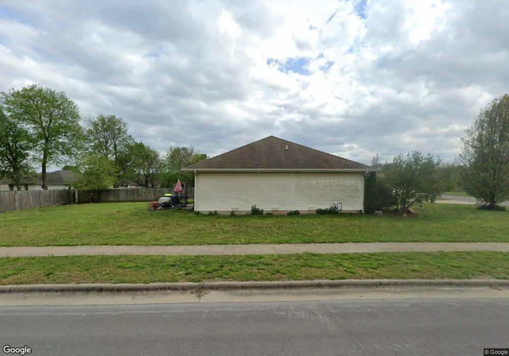
906 S Eric St Springfield, MO 65802
Estimated Value: $230,600 - $245,000
3
Beds
2
Baths
1,322
Sq Ft
$179/Sq Ft
Est. Value
About This Home
This home is located at 906 S Eric St, Springfield, MO 65802 and is currently estimated at $236,900, approximately $179 per square foot. 906 S Eric St is a home located in Greene County with nearby schools including Willard Orchard Hills Elementary School and Willard Intermediate-South.
Ownership History
Date
Name
Owned For
Owner Type
Purchase Details
Closed on
May 24, 2019
Sold by
Bishop Joseph
Bought by
Mcginnis Eric D and Mcginnis Crystal M
Current Estimated Value
Purchase Details
Closed on
Aug 14, 2009
Sold by
Mayfield Marilyn B
Bought by
Morelock Rock Properties Inc
Home Financials for this Owner
Home Financials are based on the most recent Mortgage that was taken out on this home.
Original Mortgage
$128,900
Interest Rate
5.31%
Mortgage Type
Purchase Money Mortgage
Create a Home Valuation Report for This Property
The Home Valuation Report is an in-depth analysis detailing your home's value as well as a comparison with similar homes in the area
Home Values in the Area
Average Home Value in this Area
Purchase History
| Date | Buyer | Sale Price | Title Company |
|---|---|---|---|
| Mcginnis Eric D | -- | None Available | |
| Morelock Rock Properties Inc | -- | None Available | |
| Mayfield Marilyn B | -- | None Available |
Source: Public Records
Mortgage History
| Date | Status | Borrower | Loan Amount |
|---|---|---|---|
| Previous Owner | Mayfield Marilyn B | $128,900 |
Source: Public Records
Tax History
| Year | Tax Paid | Tax Assessment Tax Assessment Total Assessment is a certain percentage of the fair market value that is determined by local assessors to be the total taxable value of land and additions on the property. | Land | Improvement |
|---|---|---|---|---|
| 2025 | $1,947 | $34,470 | $8,550 | $25,920 |
| 2024 | $1,563 | $27,870 | $3,800 | $24,070 |
| 2023 | $1,555 | $27,870 | $3,800 | $24,070 |
| 2022 | $1,354 | $24,040 | $3,800 | $20,240 |
| 2021 | $1,355 | $24,040 | $3,800 | $20,240 |
| 2020 | $1,134 | $21,870 | $3,800 | $18,070 |
| 2019 | $1,131 | $21,870 | $3,800 | $18,070 |
| 2018 | $1,096 | $21,090 | $3,800 | $17,290 |
| 2017 | $1,087 | $21,090 | $3,800 | $17,290 |
| 2016 | $1,081 | $21,090 | $3,800 | $17,290 |
| 2015 | $1,073 | $21,090 | $3,800 | $17,290 |
| 2014 | $1,072 | $20,920 | $3,800 | $17,120 |
Source: Public Records
Map
Nearby Homes
- 795 S Natalie Ave
- 820 S Quade Rd
- 987 S Natalie Ave
- 5355 Basswood Ct W
- 5348 Basswood Ct W
- 5817 W Alexa Ln
- 768 S Long Dr
- 5669 W Sunflower Dr
- 5163 W Sunstruck St
- 5175 W Sunstruck St
- 5131 W Sunstruck St
- 5601 W Pecan St
- 5565 W Pine St
- 1343 S Mulberry Ave
- 5635 W Mangrove St
- 000 W Independence Dr
- 431 S Bernier Ave
- 5021 W Tarkio St
- 4800 W Mount Vernon St
- 4853 Silo Hills Dr
- 914 S Eric St
- 894 S Eric St
- 871 S Jester Ave
- 883 S Jester Ave
- 5536 W David St
- 849 S Jester Ave
- 886 S Eric St
- 895 S Jester Ave
- 5535 W David St
- 5537 W Lombard St
- 837 S Jester Ave
- 907 S Jester Ave
- 5544 W David St
- 878 S Eric St
- 5543 W David St
- 5545 W Lombard St
- 825 S Jester Ave
- 5552 W David St
- 872 S Jester Ave
- 860 S Jester Ave
Your Personal Tour Guide
Ask me questions while you tour the home.