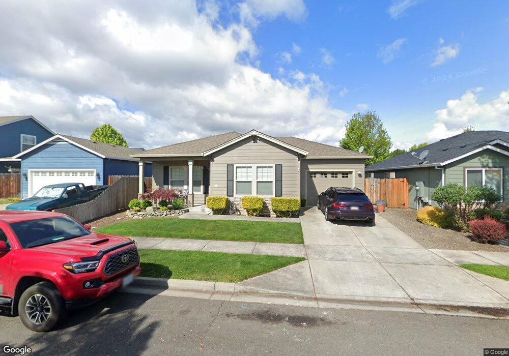
906 Silver Fox Dr Central Point, OR 97502
Estimated Value: $347,316 - $371,000
3
Beds
2
Baths
1,384
Sq Ft
$257/Sq Ft
Est. Value
About This Home
This home is located at 906 Silver Fox Dr, Central Point, OR 97502 and is currently estimated at $355,829, approximately $257 per square foot. 906 Silver Fox Dr is a home located in Jackson County with nearby schools including Richardson Elementary School, Scenic Middle School, and Crater High School.
Ownership History
Date
Name
Owned For
Owner Type
Purchase Details
Closed on
Sep 3, 2004
Sold by
Pactrend Inc
Bought by
Grensky Ronald D
Current Estimated Value
Home Financials for this Owner
Home Financials are based on the most recent Mortgage that was taken out on this home.
Original Mortgage
$146,300
Outstanding Balance
$71,284
Interest Rate
6.06%
Mortgage Type
Purchase Money Mortgage
Estimated Equity
$284,545
Purchase Details
Closed on
Oct 21, 2003
Sold by
Pactrend Inc
Bought by
Walport Bruce E and Walport Judith A
Create a Home Valuation Report for This Property
The Home Valuation Report is an in-depth analysis detailing your home's value as well as a comparison with similar homes in the area
Purchase History
| Date | Buyer | Sale Price | Title Company |
|---|---|---|---|
| Grensky Ronald D | $182,900 | Lawyers Title Ins | |
| Walport Bruce E | $168,900 | Lawyers Title Insurance Corp |
Source: Public Records
Mortgage History
| Date | Status | Borrower | Loan Amount |
|---|---|---|---|
| Open | Grensky Ronald D | $146,300 |
Source: Public Records
Tax History
| Year | Tax Paid | Tax Assessment Tax Assessment Total Assessment is a certain percentage of the fair market value that is determined by local assessors to be the total taxable value of land and additions on the property. | Land | Improvement |
|---|---|---|---|---|
| 2026 | $3,698 | $223,450 | -- | -- |
| 2025 | $3,607 | $216,950 | $62,170 | $154,780 |
| 2024 | $3,607 | $210,640 | $60,360 | $150,280 |
| 2023 | $3,491 | $204,510 | $58,600 | $145,910 |
| 2022 | $3,410 | $204,510 | $58,600 | $145,910 |
| 2021 | $3,610 | $198,560 | $56,890 | $141,670 |
| 2020 | $3,532 | $192,780 | $55,240 | $137,540 |
| 2019 | $3,466 | $181,720 | $52,070 | $129,650 |
| 2018 | $3,360 | $176,430 | $50,550 | $125,880 |
| 2017 | $3,284 | $176,430 | $50,550 | $125,880 |
| 2016 | $3,175 | $166,320 | $47,650 | $118,670 |
| 2015 | $2,961 | $166,320 | $47,650 | $118,670 |
| 2014 | $2,687 | $156,780 | $44,920 | $111,860 |
Source: Public Records
Map
Nearby Homes
- 887 Silver Fox Dr
- 827 Isherwood Dr
- 3600 N Pacific Hwy
- 755 S 4th St
- 3358 Bursell Rd
- 3364 Bursell Rd
- 556 Glenn Way
- 14 Scholarship Way
- 18 Scholarship Way
- 436 Cheney Loop
- 736 Hemlock Ave
- 1204 Heather Ln
- 895 Holley Way
- 871 Holley Way
- 114 Cedar St
- 2717 Elliott Ave
- 959 Westrop Dr
- 185 Logan Ave
- 555 Freeman Rd Unit 73
- 555 Freeman Rd Unit 254
- 902 Silver Fox Dr
- 898 Silver Fox Dr
- 900 Silver Fox Dr
- 166 Alta Ln
- 0 Silver Fox Dr
- 170 Alta Ln
- 869 Ivern Dr
- 896 Silver Fox Dr
- 865 Ivern Dr
- 892 Silver Fox Dr
- 894 Silver Fox Dr
- 873 Ivern Dr
- 861 Ivern Dr
- 909 Silver Fox Dr
- 903 Silver Fox Dr
- 915 Silver Fox Dr
- 901 Silver Fox Dr
- 899 Silver Fox Dr
- 890 Silver Fox Dr
- 897 Silver Fox Dr
Your Personal Tour Guide
Ask me questions while you tour the home.