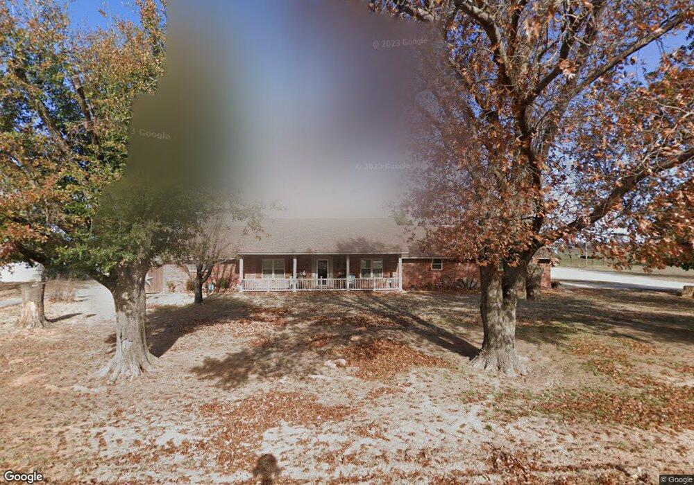
907 Brower Rd Anadarko, OK 73005
Estimated Value: $157,000 - $253,000
3
Beds
2
Baths
2,784
Sq Ft
$75/Sq Ft
Est. Value
About This Home
This home is located at 907 Brower Rd, Anadarko, OK 73005 and is currently estimated at $208,775, approximately $74 per square foot. 907 Brower Rd is a home with nearby schools including Mission Elementary School, Sunset Elementary School, and Anadarko East Elementary School.
Ownership History
Date
Name
Owned For
Owner Type
Purchase Details
Closed on
Jun 26, 2024
Sold by
Scott And Paula Brower Revocable Trust and Scott Brower K
Bought by
Brower Brian Scott and Brower Lori Lee
Current Estimated Value
Purchase Details
Closed on
Dec 27, 2017
Sold by
Knauss Brower Kenneth Scott and Knauss Brower Paula
Bought by
Brower Brian Scott and Brower Lori Lee
Purchase Details
Closed on
Oct 23, 2003
Bought by
Brower Brian S and Brower Lori L
Create a Home Valuation Report for This Property
The Home Valuation Report is an in-depth analysis detailing your home's value as well as a comparison with similar homes in the area
Home Values in the Area
Average Home Value in this Area
Purchase History
| Date | Buyer | Sale Price | Title Company |
|---|---|---|---|
| Brower Brian Scott | $16,000 | None Listed On Document | |
| Brower Brian Scott | -- | None Available | |
| Brower Brian Scott | -- | None Available | |
| Brower Brian S | $90,000 | -- |
Source: Public Records
Tax History Compared to Growth
Tax History
| Year | Tax Paid | Tax Assessment Tax Assessment Total Assessment is a certain percentage of the fair market value that is determined by local assessors to be the total taxable value of land and additions on the property. | Land | Improvement |
|---|---|---|---|---|
| 2025 | $1,098 | $13,713 | $868 | $12,845 |
| 2024 | $1,099 | $13,314 | $868 | $12,446 |
| 2023 | $1,068 | $12,926 | $868 | $12,058 |
| 2022 | $1,023 | $12,549 | $868 | $11,681 |
| 2021 | $1,011 | $12,421 | $868 | $11,553 |
| 2020 | $996 | $12,059 | $868 | $11,191 |
| 2019 | $984 | $11,708 | $868 | $10,840 |
| 2018 | $941 | $11,367 | $869 | $10,498 |
| 2017 | $939 | $11,367 | $869 | $10,498 |
| 2016 | $979 | $11,617 | $869 | $10,748 |
| 2015 | $914 | $11,670 | $869 | $10,801 |
| 2014 | $869 | $11,330 | $869 | $10,461 |
Source: Public Records
Map
Nearby Homes
- 3008 Shady Lane Dr
- 3115 Shady Lane Dr
- 3118 Shady Lane Dr
- 0 County Street 2650
- 202 Walter Way
- 1703 S Mission St
- 823 Wilshire Terrace
- 1618 S David St
- 1201 SW 8th St
- 807 W Colorado Ave
- 905 SW 8th St
- 1009 W Sunset Dr
- 802 S Mission St
- 313 W Texas Ave
- 406 E Texas Dr
- 314 W Kentucky Ave
- 1007 Mimosa Dr
- 113 W Washington Ave
- 0000 S Blvd
- Rr N2630 Rd
- 925 Brower Rd
- 1001 Brower Rd
- 3004 Shady Lane Dr
- 3002 Shady Ln
- 1119 Brower Rd
- 3006 Shady Lane Dr
- 3008 Shady Lane Dr
- 3001 Shady Ln
- 3003 Shady Lane Dr
- 3010 Shady Lane Dr
- 3005 Shady Lane Dr
- 0 Shady Lane Dr
- 3012 Shady Lane Dr
- 3014 Shady Lane Dr
- 3004 S Mission St
- 3006 S Mission St
- 3016 Shady Lane Dr
- 3008 S Mission St
- 3010 S Mission St
- 3012 S Mission St