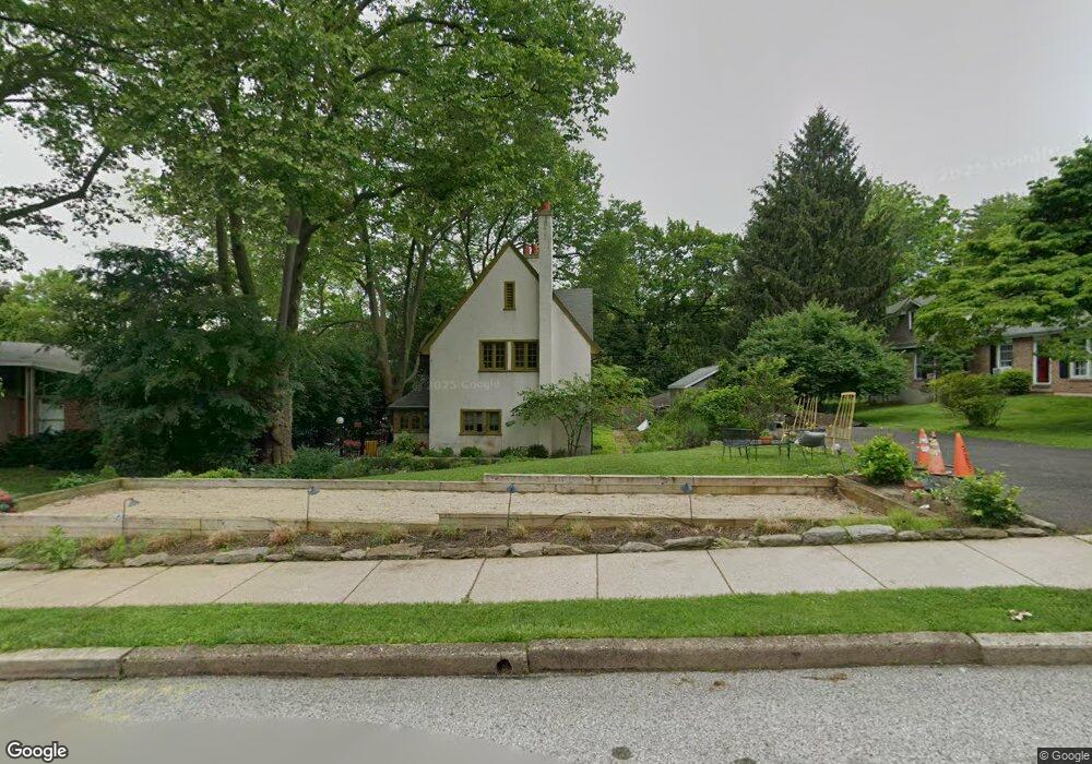
907 Harston Ln Glenside, PA 19038
Estimated Value: $480,000 - $613,000
6
Beds
2
Baths
2,464
Sq Ft
$222/Sq Ft
Est. Value
About This Home
This home is located at 907 Harston Ln, Glenside, PA 19038 and is currently estimated at $547,135, approximately $222 per square foot. 907 Harston Ln is a home located in Montgomery County with nearby schools including Erdenheim Elementary School, Enfield Elementary School, and Springfield Township Middle School.
Ownership History
Date
Name
Owned For
Owner Type
Purchase Details
Closed on
Jul 22, 2005
Sold by
Greenfield Leonard Owen and Greenfield Marilyn Malone
Bought by
Boccella Christopher and Boccella Kerry
Current Estimated Value
Home Financials for this Owner
Home Financials are based on the most recent Mortgage that was taken out on this home.
Original Mortgage
$29,200
Interest Rate
5.63%
Mortgage Type
Stand Alone Second
Create a Home Valuation Report for This Property
The Home Valuation Report is an in-depth analysis detailing your home's value as well as a comparison with similar homes in the area
Home Values in the Area
Average Home Value in this Area
Purchase History
| Date | Buyer | Sale Price | Title Company |
|---|---|---|---|
| Boccella Christopher | $292,500 | T A Title Insurance Co |
Source: Public Records
Mortgage History
| Date | Status | Borrower | Loan Amount |
|---|---|---|---|
| Closed | Boccella Christopher | $29,200 |
Source: Public Records
Tax History
| Year | Tax Paid | Tax Assessment Tax Assessment Total Assessment is a certain percentage of the fair market value that is determined by local assessors to be the total taxable value of land and additions on the property. | Land | Improvement |
|---|---|---|---|---|
| 2025 | $7,026 | $149,160 | $48,760 | $100,400 |
| 2024 | $7,026 | $149,160 | $48,760 | $100,400 |
| 2023 | $6,781 | $149,160 | $48,760 | $100,400 |
| 2022 | $6,587 | $149,160 | $48,760 | $100,400 |
| 2021 | $6,415 | $149,160 | $48,760 | $100,400 |
| 2020 | $6,265 | $149,160 | $48,760 | $100,400 |
| 2019 | $6,169 | $149,160 | $48,760 | $100,400 |
Source: Public Records
Map
Nearby Homes
- 305 Glenway Rd
- 402 Pennybrook Ct
- 404 Pennybrook Ct Unit 15 REDFORD INTERIOR
- 401 Pennybrook Ct Unit 1 REDFORD END
- 403 Pennybrook Ct Unit 2 REDFORD INTERIOR
- 001 Pennybrook Ct Unit REDFORD INTERIOR
- 418 Glenway Rd
- 405 Pennybrook Ct Unit 3 REDFORD INTERIOR
- 407 Pennybrook Ct Unit 4 REDFORD END
- 423 Pennybrook Ct Unit 6 REDFORD INTERIOR
- 421 Pennybrook Ct Unit 5 REDFORD END
- 300 Preston Rd
- 216 Heatherwood Rd
- 111 Chesney Ln
- 8609 Trumbauer Dr Unit L57
- 99 Rorer St
- 8550 Trumbauer Dr Unit L35
- 107 E Mill Rd
- 5 Highland Ave Unit 30
- 28 Grove Ave
Your Personal Tour Guide
Ask me questions while you tour the home.