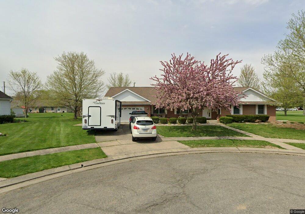
907 Lateglow Ct Newark, OH 43055
Estimated Value: $353,000 - $366,000
3
Beds
3
Baths
1,952
Sq Ft
$184/Sq Ft
Est. Value
About This Home
This home is located at 907 Lateglow Ct, Newark, OH 43055 and is currently estimated at $359,614, approximately $184 per square foot. 907 Lateglow Ct is a home located in Licking County with nearby schools including Legend Elementary School, Liberty Middle School, and Newark High School.
Ownership History
Date
Name
Owned For
Owner Type
Purchase Details
Closed on
Feb 5, 2020
Sold by
Dispennette Earl Douglas and Dispennette Jo Anne
Bought by
Andrews Deanna K and Jacobson Michael L
Current Estimated Value
Purchase Details
Closed on
Oct 30, 2009
Sold by
Estate Of Ralph Dispennette
Bought by
Dispennette Earl Douglas and Andrews Deanna K
Purchase Details
Closed on
Jul 31, 1995
Sold by
Owen Potato Farm Inc
Bought by
Ralph and Dispennette Opal
Home Financials for this Owner
Home Financials are based on the most recent Mortgage that was taken out on this home.
Original Mortgage
$145,500
Interest Rate
7.59%
Mortgage Type
New Conventional
Create a Home Valuation Report for This Property
The Home Valuation Report is an in-depth analysis detailing your home's value as well as a comparison with similar homes in the area
Home Values in the Area
Average Home Value in this Area
Purchase History
| Date | Buyer | Sale Price | Title Company |
|---|---|---|---|
| Andrews Deanna K | $80,000 | None Available | |
| Dispennette Earl Douglas | -- | None Available | |
| Ralph | $23,500 | -- |
Source: Public Records
Mortgage History
| Date | Status | Borrower | Loan Amount |
|---|---|---|---|
| Previous Owner | Ralph | $145,500 |
Source: Public Records
Tax History Compared to Growth
Tax History
| Year | Tax Paid | Tax Assessment Tax Assessment Total Assessment is a certain percentage of the fair market value that is determined by local assessors to be the total taxable value of land and additions on the property. | Land | Improvement |
|---|---|---|---|---|
| 2024 | $3,577 | $100,070 | $24,500 | $75,570 |
| 2023 | $3,570 | $100,070 | $24,500 | $75,570 |
| 2022 | $2,850 | $71,120 | $14,980 | $56,140 |
| 2021 | $2,989 | $71,120 | $14,980 | $56,140 |
| 2020 | $3,062 | $71,120 | $14,980 | $56,140 |
| 2019 | $3,027 | $66,120 | $9,980 | $56,140 |
| 2018 | $3,029 | $0 | $0 | $0 |
| 2017 | $2,901 | $0 | $0 | $0 |
| 2016 | $2,822 | $0 | $0 | $0 |
| 2015 | $2,883 | $0 | $0 | $0 |
| 2014 | $3,598 | $0 | $0 | $0 |
| 2013 | $3,048 | $0 | $0 | $0 |
Source: Public Records
Map
Nearby Homes
- 913 Roosevelt Ct
- 892 Shelbourne Place Unit 892
- 863 Shelbourne Place Unit 863
- 584 Moull St Unit A
- 855 E Village Dr
- 473 Meadowbrook Dr
- 752 Maxola Ave
- 440 Reverie Place
- 188 Meadow Dr
- 184 Meadow Dr
- 632 Granville Rd
- 370 Meadowbrook Dr
- 596 Velma Ave
- 594 N 21st St
- 533 Leslie Dr
- 565 Granville St
- 562 Jutlew Rd
- 36 Hall Ave
- 830 Walker St
- 245 Rugg Ave
- 901 Lateglow Ct
- 908 Empire Dr
- 902 Empire Dr
- 914 Empire Dr
- 896 Empire Dr
- 898 Lateglow Ct
- 906 Lateglow Ct
- 684 Robinson Dr
- 916 Lateglow Ct
- 674 Robinson Dr
- 927 Lateglow Ct
- 890 Empire Dr
- 922 Lateglow Ct
- 664 Robinson Dr
- 930 Lateglow Ct
- 903 Adams Ave
- 907 Adams Ave
- 935 Late Glow Ct
- 895 Adams Ave
- 935 Lateglow Ct