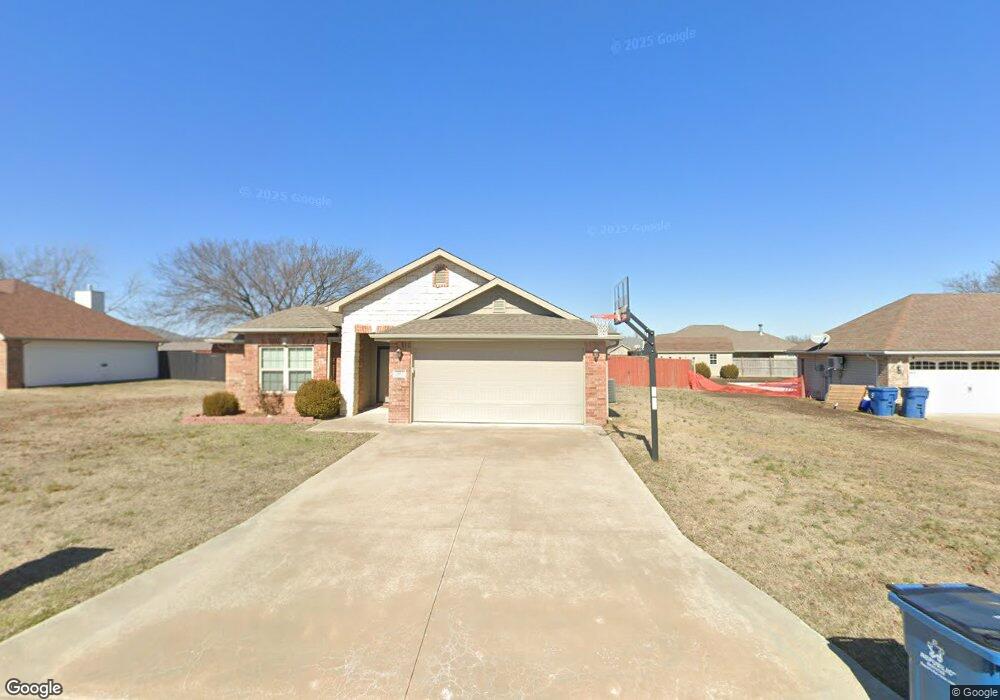
907 Monroe Cir Carl Junction, MO 64834
Estimated Value: $290,271 - $328,000
4
Beds
2
Baths
2,008
Sq Ft
$153/Sq Ft
Est. Value
About This Home
This home is located at 907 Monroe Cir, Carl Junction, MO 64834 and is currently estimated at $307,068, approximately $152 per square foot. 907 Monroe Cir is a home located in Jasper County with nearby schools including Carl Junction Primary School (K-1), Carl Junction Intermediate School, and Carl Junction Primary School (2-3).
Ownership History
Date
Name
Owned For
Owner Type
Purchase Details
Closed on
Jul 8, 2015
Sold by
Schuber Mitchell Homes Llc
Bought by
Kellogg Bobbie
Current Estimated Value
Home Financials for this Owner
Home Financials are based on the most recent Mortgage that was taken out on this home.
Original Mortgage
$141,912
Outstanding Balance
$109,606
Interest Rate
3.91%
Mortgage Type
New Conventional
Estimated Equity
$197,462
Purchase Details
Closed on
Jan 30, 2015
Sold by
Red Wood Development Of Kansas Inc
Bought by
Schuber Mitchell Homes Llc
Create a Home Valuation Report for This Property
The Home Valuation Report is an in-depth analysis detailing your home's value as well as a comparison with similar homes in the area
Purchase History
We collect this data history from publicly available records. To have your information removed, we recommend requesting removal directly through your county’s website.
| Date | Buyer | Sale Price | Title Company |
|---|---|---|---|
| Kellogg Bobbie | -- | -- | |
| Schuber Mitchell Homes Llc | -- | Waco Title Company Joplin |
Source: Public Records
Mortgage History
We collect this data history from publicly available records. To have your information removed, we recommend requesting removal directly through your county’s website.
| Date | Status | Borrower | Loan Amount |
|---|---|---|---|
| Open | Kellogg Bobbie | $141,912 |
Source: Public Records
Tax History
| Year | Tax Paid | Tax Assessment Tax Assessment Total Assessment is a certain percentage of the fair market value that is determined by local assessors to be the total taxable value of land and additions on the property. | Land | Improvement |
|---|---|---|---|---|
| 2025 | $1,842 | $35,680 | $2,290 | $33,390 |
| 2024 | $1,842 | $31,480 | $2,290 | $29,190 |
| 2023 | $1,853 | $31,480 | $2,290 | $29,190 |
| 2022 | $1,893 | $32,070 | $2,290 | $29,780 |
| 2021 | $1,624 | $32,070 | $2,290 | $29,780 |
| 2020 | $1,515 | $29,400 | $2,290 | $27,110 |
| 2019 | $1,438 | $29,400 | $2,290 | $27,110 |
| 2018 | $1,476 | $30,250 | $0 | $0 |
| 2017 | $1,480 | $30,250 | $0 | $0 |
| 2016 | $1,410 | $29,100 | $0 | $0 |
| 2015 | $109 | $2,290 | $0 | $0 |
| 2014 | $109 | $2,290 | $0 | $0 |
Source: Public Records
Map
Nearby Homes
- 821 Nicholas
- 904 Larson St
- 705 Elliott Dr
- TBD Route Yy
- 29320 State Highway Yy
- 817 Delaney Dr
- 901 Delaney Dr
- xxx Prairie Ln
- 711 Prairie Ln
- 206 N Broadway St
- 804 Aberdeen Ave
- 806 Aberdeen Ave
- 808 Aberdeen Ave
- 900 Aberdeen Ave
- 904 Aberdeen Ave
- 906 Aberdeen Ave
- 908 Aberdeen Ave
- 1000 Aberdeen Ave
- 805 Aberdeen Ave
- 807 Aberdeen Ave
Your Personal Tour Guide
Ask me questions while you tour the home.