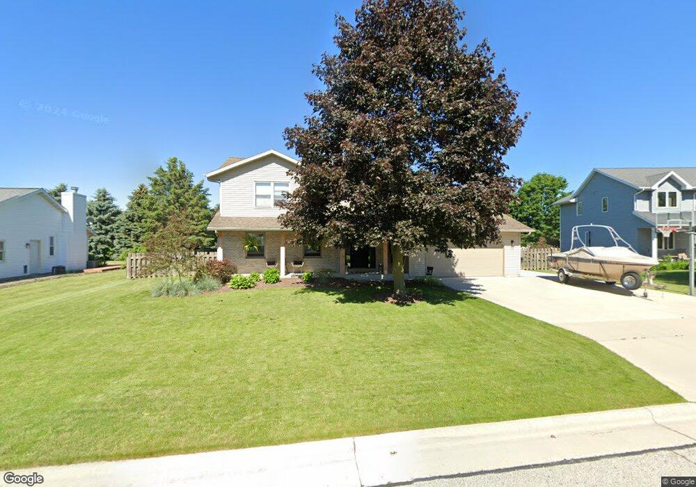
908 Ash Cir Plymouth, WI 53073
Estimated Value: $438,793 - $519,000
3
Beds
3
Baths
2,523
Sq Ft
$189/Sq Ft
Est. Value
About This Home
This home is located at 908 Ash Cir, Plymouth, WI 53073 and is currently estimated at $477,448, approximately $189 per square foot. 908 Ash Cir is a home located in Sheboygan County with nearby schools including Plymouth High School, St. John the Baptist Catholic School, and St. John Lutheran School.
Ownership History
Date
Name
Owned For
Owner Type
Purchase Details
Closed on
Dec 18, 2020
Sold by
Olmer Scott D and Olmer Lisa M
Bought by
Hogue Kevin M and Zimmer Kimberly A
Current Estimated Value
Home Financials for this Owner
Home Financials are based on the most recent Mortgage that was taken out on this home.
Original Mortgage
$256,700
Outstanding Balance
$186,338
Interest Rate
2.7%
Mortgage Type
New Conventional
Estimated Equity
$291,110
Purchase Details
Closed on
Apr 1, 2013
Sold by
Olmer Scott D. & Lisa M. Scott D. & Lisa M.
Bought by
Heiser Robert M and Heiser Barbara L
Create a Home Valuation Report for This Property
The Home Valuation Report is an in-depth analysis detailing your home's value as well as a comparison with similar homes in the area
Home Values in the Area
Average Home Value in this Area
Purchase History
| Date | Buyer | Sale Price | Title Company |
|---|---|---|---|
| Hogue Kevin M | $320,900 | Champion Title | |
| Heiser Robert M | $212,000 | -- |
Source: Public Records
Mortgage History
| Date | Status | Borrower | Loan Amount |
|---|---|---|---|
| Open | Hogue Kevin M | $256,700 |
Source: Public Records
Tax History Compared to Growth
Tax History
| Year | Tax Paid | Tax Assessment Tax Assessment Total Assessment is a certain percentage of the fair market value that is determined by local assessors to be the total taxable value of land and additions on the property. | Land | Improvement |
|---|---|---|---|---|
| 2024 | $6,047 | $329,100 | $36,200 | $292,900 |
| 2023 | $5,907 | $329,100 | $36,200 | $292,900 |
| 2022 | $5,046 | $329,100 | $36,200 | $292,900 |
| 2021 | $5,455 | $261,000 | $34,000 | $227,000 |
| 2020 | $4,881 | $233,600 | $34,000 | $199,600 |
| 2019 | $4,838 | $233,600 | $34,000 | $199,600 |
| 2018 | $4,595 | $231,100 | $34,000 | $197,100 |
| 2017 | $4,474 | $231,100 | $34,000 | $197,100 |
| 2016 | $4,446 | $231,100 | $34,000 | $197,100 |
| 2015 | $4,518 | $231,100 | $34,000 | $197,100 |
| 2014 | $4,492 | $231,100 | $34,000 | $197,100 |
Source: Public Records
Map
Nearby Homes
- 928 S Hills Dr
- Lt64 Upper Greystone Dr
- Lt63 Upper Greystone Dr
- Lt65 Upper Greystone Dr
- Lt61 Upper Greystone Dr
- 142 Maple Dr
- Lt53 Upper Greystone Dr
- Elizabeth Plan at Greystone Settlement
- Springfield Plan at Greystone Settlement
- Simen Plan at Greystone Settlement
- Montrose Manor II Plan at Greystone Settlement
- Vintage Plan at Greystone Settlement
- Barbara Plan at Greystone Settlement
- Sarah Plan at Greystone Settlement
- Elizabeth II Plan at Greystone Settlement
- Simen II Plan at Greystone Settlement
- Isabelle II Plan at Greystone Settlement
- Nottingham Plan at Greystone Settlement
- Nottingham II Plan at Greystone Settlement
- Sarah III Plan at Greystone Settlement