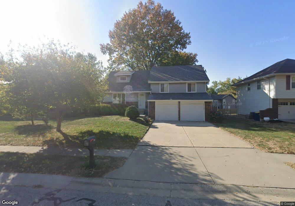
908 Bristol Way Liberty, MO 64068
Estimated Value: $318,000 - $351,000
4
Beds
2
Baths
1,584
Sq Ft
$212/Sq Ft
Est. Value
About This Home
This home is located at 908 Bristol Way, Liberty, MO 64068 and is currently estimated at $336,420, approximately $212 per square foot. 908 Bristol Way is a home located in Clay County with nearby schools including Alexander Doniphan Elementary School, Liberty Middle School, and Liberty High School.
Ownership History
Date
Name
Owned For
Owner Type
Purchase Details
Closed on
Dec 6, 2011
Sold by
Thompson Susan L
Bought by
Thompson Susan L and Susan L Thompson Trust
Current Estimated Value
Purchase Details
Closed on
Jun 21, 2011
Sold by
Thompson David A
Bought by
Thompson Susan L
Purchase Details
Closed on
Jul 7, 1997
Sold by
Schoeller Ronald J and Schoeller William F
Bought by
Thompson David A and Thompson Susan L
Home Financials for this Owner
Home Financials are based on the most recent Mortgage that was taken out on this home.
Original Mortgage
$114,000
Outstanding Balance
$16,656
Interest Rate
7.72%
Estimated Equity
$319,764
Create a Home Valuation Report for This Property
The Home Valuation Report is an in-depth analysis detailing your home's value as well as a comparison with similar homes in the area
Home Values in the Area
Average Home Value in this Area
Purchase History
| Date | Buyer | Sale Price | Title Company |
|---|---|---|---|
| Thompson Susan L | -- | None Available | |
| Thompson Susan L | -- | None Available | |
| Thompson David A | $120,000 | -- |
Source: Public Records
Mortgage History
| Date | Status | Borrower | Loan Amount |
|---|---|---|---|
| Open | Thompson David A | $114,000 |
Source: Public Records
Tax History Compared to Growth
Tax History
| Year | Tax Paid | Tax Assessment Tax Assessment Total Assessment is a certain percentage of the fair market value that is determined by local assessors to be the total taxable value of land and additions on the property. | Land | Improvement |
|---|---|---|---|---|
| 2025 | $3,189 | $48,750 | -- | -- |
| 2024 | $3,189 | $41,460 | -- | -- |
| 2023 | $3,243 | $41,460 | $0 | $0 |
| 2022 | $2,950 | $37,240 | $0 | $0 |
| 2021 | $2,927 | $37,240 | $7,220 | $30,020 |
| 2020 | $2,638 | $31,520 | $0 | $0 |
| 2019 | $2,638 | $31,520 | $0 | $0 |
| 2018 | $2,462 | $28,880 | $0 | $0 |
| 2017 | $2,439 | $28,880 | $4,560 | $24,320 |
| 2016 | $2,439 | $28,880 | $4,560 | $24,320 |
| 2015 | $2,439 | $28,880 | $4,560 | $24,320 |
| 2014 | $2,340 | $27,490 | $4,370 | $23,120 |
Source: Public Records
Map
Nearby Homes
- 862 Amesbury Ave
- 918 Amesbury Ave
- 716 Bristol Ct
- 1124 Amesbury Ave
- 1218 Canterbury Ln
- 1331 Park Ln
- 1317 Park Ln
- 1209 Liberty Drive Terrace
- 1323 Amesbury Ave
- 415 Monterey Ave
- 1304 Wellington Way
- 509 Belmont St
- 1507 Amesbury Ave
- 1327 Easton Ct
- 420 Belmont St
- 1537 Canterbury Ln
- 1733 Welleslay Ln
- 1025 Orchard Ave
- 248 Range Line Rd
- 1030 Maple Woods Dr
- 914 Bristol Way
- 902 Bristol Way
- 901 Amesbury Ave
- 907 Amesbury Ave
- 862 Bristol Way
- 920 Bristol Way
- 861 Amesbury Ave
- 913 Amesbury Ave
- 907 Bristol Way
- 913 Bristol Way
- 855 Amesbury Ave
- 856 Bristol Way
- 901 Bristol Way
- 926 Bristol Way
- 919 Bristol Way
- 919 Amesbury Ave
- 861 Bristol Way
- 925 Bristol Way
- 932 Bristol Way
- 849 Amesbury Ave